- Chester River
-
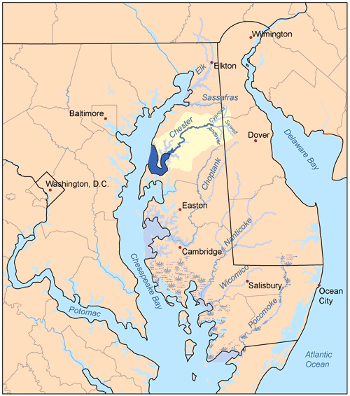
 Map of the rivers of the Eastern Shore of Maryland with the Chester and its watershed highlighted.
The Chester River is a major tributary of the Chesapeake Bay on the Delmarva Peninsula. It is about 43 miles (69 km) long,[1] and its watershed encompasses 368 sq mi (950 km2), which includes 295 sq mi (760 km2) of land. Thus the total watershed area is 20% water. It forms the border between Kent County and Queen Anne's County, Maryland, with its headwaters extending into New Castle County and Kent County, Delaware. Chestertown, the county seat of Kent County is located on its north shore. It is located south of the Sassafras River and north of Eastern Bay, and is connected with Eastern Bay through Kent Narrows.
The Chester River begins at Millington, Maryland, where Cypress Branch and Andover Branch join together. It ends at the Chesapeake Bay in a very wide mouth between Love Point on Kent Island, and Swan Point, near Gratitude, Maryland. Cypress Branch rises in southwestern New Castle County, Delaware, and Andover Branch, with its tributary, Sewell Branch, rises in northwestern Kent County, Delaware. Millington is the head of navigation. Sewell Branch and Andover Branch join in a private impoundage of approximately 30 acres (120,000 m2) about two miles (3 km) above joining with Cypress Branch and then becoming the Chester River.
Its main tributaries are Langford Creek and Morgan Creek on the north side and the Corsica River and Southeast Creek on the south side. There are also several small creeks on the northern shore, including Church Creek, Grays Inn Creek, Shippen Creek, Jarrett Creek, Browns Creek, Broad Creek, Dam Creek, Morgan Creek, Radcliffe Creek, and Mills Branch. On the southern shore the small creeks include Queenstown Creek, Tilghman Creek, Reed Creek, Grove Creek, Hambleton Creek, Rosin Creek, Foreman Branch and Unicorn Branch.
History
Local lore has it that in 1774, colonists boarded a British ship anchored in the Chester River at Chester Town, also called New Town on Chester, and threw its load of tea overboard, mimicking the Boston Tea Party and its act of defiance against King George III. This came to be known as the Chestertown Tea Party.
While primary source documents show that Chestertown residents did have at least one meeting to discuss the presence of tea aboard the locally-owned merchantman Geddes, and later the residents sent food to aid the blockaded Bostonians, contemporary source material has yet to be found.
References
- ^ U.S. Geological Survey. National Hydrography Dataset high-resolution flowline data. The National Map, accessed April 1, 2011
- United States Geological Survey. 7.5 minute series topographic quadrangles.
- Chesapeake Bay Program Watershed Profile Lower Chester River
- Chesapeake Bay Program Watershed Profile Middle Chester River
- Chesapeake Bay Program Watershed Profile Upper Chester River
External links
- Chester River Association
- Maryland DNR's Surf Your Watershed: Lower Chester River
- Maryland DNR's Surf Your Watershed: Middle Chester River
- Maryland DNR's Surf Your Watershed: Upper Chester River
Waters of Maryland Bays/Estuaries Assawoman • Chesapeake • Chincoteague • Eastern • Fishing • Herring • Isle of Wight • Mallows • Newport • Pocomoke • Sinepuxent • TangierRivers Anacostia • Annemessex (Big) • Annemessex (Little) • Back • Bird • Blackwater • Blackwater (Little) • Bohemia • Bush • Casselman • Chester • Chicamacomico • Choptank • Choptank (Little) • Christina River • Corsica • Elk • Front • Gunpowder • Hawlings • Jones Falls • Magothy • Magothy (Little) • Manokin • Middle • Miles • Monocacy • Monocacy (Little) • Nanticoke • North East • Patapsco • Patuxent • Pocomoke • Port Tobacco • Potomac • Rhode • St. Martin • St. Marys • Sassafras • Savage • Severn • South • Susquehanna • Transquaking • Tred Avon • Warwick • West • Wicomico (Potomac) • Wicomico • Wye • Wye East • YoughioghenyCreeks/Runs/Streams Antietam • Alloway • Ballenger • Bear (Patapsco) • Bear (Sideling Hill) • Bear (Youghiogheny) • Bennett • Big Pipe • Bodkin • Bread and Cheese • Broad (Choptank) • Broad (Potomac) • Broad (Susquehanna) • Broad Run • Budds • Cabin John • Carroll • Catoctin • Catoctin (Little) • Chicamuxen • Conococheague • Conococheague (Little) • Conowingo • Cuckold • Curtis • Deep Run • Deer • Dividing • Double Pipe • Dry Seneca • Dueling • Dundee • Evitts • Fifteenmile • Fishing • Flintstone • Frog Mortar • Furnace • Georges • Great Seneca • Greys • Gwynns Falls • Harris • Henson • Herring Run • Honga • Indian (Anacostia) • Indian (Patuxent) • Israel • Laurel Run • Licking • Linganore • Little Falls Branch • Little Pipe • Little Seneca • Lyons • Main • Marley • Marsh • Marshyhope • Mattawoman • Meekins • Middle • Minnehaha Branch • Moores Run • Muddy Branch • Nanjemoy • Nassawango • Northeast Branch Anacostia River • Northwest Branch Anacostia River • Octoraro • Owens • Oxon • Paint Branch • Parsons • Piney • Piscataway • Pomonkey • Rock (Potomac) • Rock Run • Rockburn Branch • Romney • St. Leonard • Saltpeter • Sams Creek • Sellman • Seneca (Middle) • Seneca (Potomac) • Sideling Hill • Slaughter • Sligo • Stony • Swanson • Toms • Tonoloway • Town (Patuxent) • Town (Potomac) • Town (Tred Avon) • Trappe • Tuckahoe • Turville • Tuscarora (Monocacy) • Tuscarora (Potomac) • Tuscarora (Little) • Watts Branch • Wills • Winters RunLakes Artemesia • Centennial • Deep Creek • Elkhorn • Bernard Frank • Jennings Randolph • Kittamaqundi • Little Seneca • Needwood • Roland • YoughioghenyReservoirs Coordinates: 39°2′1.87″N 76°11′43.21″W / 39.0338528°N 76.1953361°W
Categories:- Chesapeake Bay Watershed
- Rivers of Maryland
Wikimedia Foundation. 2010.