- Dingwall railway station
-
Dingwall 
Inbhirpheofharain 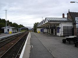
Dingwall station Location Place Dingwall Local authority Highland Coordinates 57°35′39″N 4°25′22″W / 57.5941°N 4.4228°WCoordinates: 57°35′39″N 4°25′22″W / 57.5941°N 4.4228°W Operations Station code DIN Managed by First ScotRail Number of platforms 2 Live arrivals/departures and station information
from National Rail EnquiriesAnnual rail passenger usage 2004/05 * 34,898 2005/06 * 43,508 2006/07 * 55,034 2007/08 * 64,404 2008/09 * 72,086 2009/10 * 80,324 History Original company Inverness and Ross-shire Railway Pre-grouping Highland Railway Post-grouping LMS 11 June 1862[1] Opened National Rail - UK railway stations A B C D E F G H I J K L M N O P Q R S T U V W X Y Z * Annual passenger usage based on sales of tickets in stated financial year(s) which end or originate at Dingwall from Office of Rail Regulation statistics. Please note: methodology may vary year on year.  Dingwall Station in 1957
Dingwall railway station serves Dingwall, in the Highland council area of Scotland. It is located just south of the junction of the Far North Line and the Kyle of Lochalsh Line, and is served by First ScotRail. To the south is the proposed station of Conon Bridge. A recent increase of services has increased usage dramatically (see figures right).
Contents
History
The station was built by the Inverness and Ross-shire Railway (I&RR) and opened on 11 June 1862 when the company's line was opened from Inverness to Dingwall. The extension to Invergordon came on 23 March 1863. The I&RR was consolidated with the Inverness and Aberdeen Junction Railway on 30 June 1862. The operating name became the Highland Railway (HR) on 29 June 1865. The HR became a constituent of the London Midland and Scottish Railway (LMSR) in 1923.[2]
The main passenger services through the station were to Wick and Thurso and to Kyle of Lochalsh. Between 1885 and 1946 there was a branch line service to Strathpeffer.[3]
The Highland Railway built a small steam locomotive shed near the station and this continued in use by the LMSR and British Railways until closure at the end of steam locomotive operations in the area in the early 1960s. It was a sub-shed of the large Inverness facility.[4]
Station signage
The town's name in Scottish Gaelic is Inbhir Pheofharain;[5] however, the Gaelic on the station sign reads Inbhirpheofharain (incorrectly written as one word). Transport Scotland has acknowledged the error and indicated that the correct signage will be erected during 2014.[citation needed]
New annunciator LED screens have been installed on both platforms, giving information on the next three trains to arrive, and general security information.
2010 derailment
On 22 January 2010, a Class 158 Express Sprinter unit (158701) working the 17:15 Inverness to Ardgay service derailed at Dingwall, leaving one female passenger injured.[citation needed]
Services
-
- Service provision at Dingwall forms part of the Far North and Kyle of Lochalsh Lines
Preceding station  National Rail
Following station Muir of Ord First ScotRail
Kyle of Lochalsh LineGarve First ScotRail
Far North LineAlness Historical railways Conon
Line open; station closedHighland Railway
Foulis
Line open; station closedJunction with
Inverness and Ross-shire RailwayHighland Railway
Achterneed
Line open; station closedHighland Railway
Strathpeffer
Line partially open; station closedGallery
-

Dingwall station in 1970
-

Dingwall station looking south
-

The station at night in 2008
-

Dingwall Engine Shed in 1957
References
Notes
Sources
- Awdry, Christopher (1990). Encyclopaedia of British Railway Companies. Sparkford: Patrick Stephens Ltd. ISBN 1-8526-0049-7. OCLC 19514063.
- Butt, R. V. J. (1995). The Directory of Railway Stations: details every public and private passenger station, halt, platform and stopping place, past and present (1st ed.). Sparkford: Patrick Stephens Ltd. ISBN 1-8526-0508-1. OCLC 60251199.
- Fuller, Aidan L.F. (1961). British Locomotive Shed Directory. Railway Publications Ltd. ISBN none.
- Jowett, Alan (March 1989). Jowett's Railway Atlas of Great Britain and Ireland: From Pre-Grouping to the Present Day (1st ed.). Sparkford: Patrick Stephens Ltd. ISBN 1-8526-0086-1. OCLC 22311137.
- Jowett, Alan (2000). Jowett's Nationalised Railway Atlas (1st ed.). Penryn, Cornwall: Atlantic Transport Publishers. ISBN 0-9068-9999-0. OCLC 228266687.
Categories:- Railway stations in Highland (council area)
- Railway stations opened in 1862
- Railway stations served by First ScotRail
- Former Highland Railway stations
-


Wikimedia Foundation. 2010.