- City of St Kilda
-
This article is about a former local government area. For the suburb, see St Kilda, Victoria.
City of St Kilda
Victoria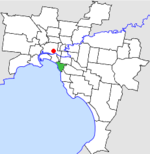
Location in MelbournePopulation: 45,889 (1992)[1] Established: 1855 Area: 8.70 km² (3.4 sq mi) Council Seat: St Kilda Region: Melbourne County: Bourke LGAs around City of St Kilda: South Melbourne Melbourne Prahran Port Phillip City of St Kilda Caulfield Port Phillip Brighton Caulfield  Final logo used by the City of St Kilda
The City of St Kilda was a Local Government Area located on Port Phillip about 5 kilometres (3.1 mi) south of Melbourne, the state capital of Victoria, Australia. The city covered an area of 8.70 square kilometres (3.36 sq mi), and existed from 1855 until 1994.
Contents
History
St Kilda was first incorporated as a district on 24 April 1855, and became a Borough in April 1863. It was proclaimed a City on 8 September 1890.[2]
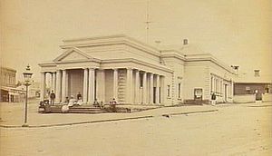 The first town hall corner of Grey and Barkly Streets
Council meetings were first held at the St Kilda Police Station at the St Kilda Junction before the city's first town hall was built in 1859 on the corner of Grey and Barkly streets.[3]
A new town hall was built for the city on the corner of Carlisle Street and Brighton Road. The site was reserved in 1883, selected in 1887 with plans drawn up by architect William Pitt in 1888.[4]
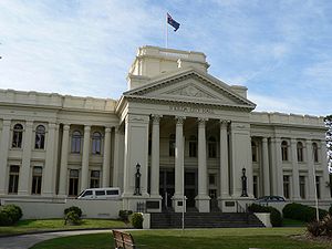 St Kilda Town Hall on the corner of Carlisle and St Kilda Road
On 22 June 1994, the City of St Kilda was abolished and merged into the newly-created City of Port Phillip along with the Cities of Port Melbourne and South Melbourne.[5]
The council met at the St Kilda Town Hall at the intersection of St Kilda Road and Carlisle Street, St Kilda. The facility is now the main council chambers for the City of Port Phillip.
Wards
St Kilda was divided into four wards on 5 April 1987, each electing three councillors:[2]
- North Ward
- West Ward
- Centre Ward
- South Ward
Suburbs
The council area was bounded by Fraser and Lorne Streets, Punt Road and Wellington Street/Dandenong Road to the north; Orrong Road, Inkerman Street and Hotham Street to the east, Glen Huntly Road, St Kilda Street and Head Street to the south, and Port Phillip to the west.[6]
Suburbs within the City of St Kilda were:
- Balaclava
- Elwood
- Ripponlea
- St Kilda
- St Kilda East (shared with City of Caulfield)
Population
Year Population 1861 6,408 1901 20,542 1921 38,579 1947 58,318 1954 53,301 1958 51,200* 1961 52,205 1966 58,179 1971 61,203 1976 51,254 1981 49,366 1986 45,889 1991 45,481 * Estimate in the 1958 Victorian Year Book.
References
- ^ Australian Bureau of Statistics, Victoria Office (1994). Victorian Year Book. p. 50. ISSN 0067-1223.
- ^ a b Victorian Municipal Directory. Brunswick: Arnall & Jackson. 1992. pp. 497–498. Accessed at State Library of Victoria, La Trobe Reading Room.
- ^ http://www.skhs.org.au/SKHSbuildings/33.htm
- ^ ibid
- ^ Australian Bureau of Statistics (1 August 1995). Victorian local government amalgamations 1994-1995: Changes to the Australian Standard Geographical Classification. Commonwealth of Australia. p. 11. ISBN 0-642-23117-6. http://www.ausstats.abs.gov.au/ausstats/free.nsf/0/76E601D6DB55E88ACA25722500049195/$File/12570_1994-95.pdf. Retrieved 2007-12-16.
- ^ Melway - Greater Melbourne Street Directory (22nd edition). Glen Iris, Victoria: Melway Publishing Pty Ltd. 1993. pp. Maps 57, 67. ISSN 0311-3957.
Former Local Government Areas in Melbourne, Victoria Altona · Berwick · Box Hill · Brighton · Broadmeadows · Brunswick · Bulla (S) · Camberwell · Caulfield · Chelsea · Coburg · Collingwood · Cranbourne · Croydon · Diamond Valley (S) · Doncaster & Templestowe · Dandenong · Eltham (S) · Essendon · Fitzroy · Flinders (S) · Footscray · Frankston · Hastings (S) · Hawthorn · Healesville (S) · Heidelberg · Keilor · Kew · Lillydale (S) · Malvern · Moorabbin · Mordialloc · Mornington (S) · Northcote · Nunawading · Oakleigh · Pakenham (S) · Port Melbourne · Prahran · Preston · Richmond · Ringwood · Sandringham · Sherbrooke (S) · South Melbourne · Springvale · St Kilda · Sunshine · Upper Yarra (S) · Waverley · Werribee · Williamstown
Categories:- Former Local Government Areas of Victoria (Australia)


Wikimedia Foundation. 2010.