- Narmada district
-
 Districts of central Gujarat
Narmada district (Gujarati: નર્મદા જીલ્લો) is an administrative district in the state of Gujarat in India. The district headquarters are located at Rajpipla. The district is bounded by Vadodara district in the north, by Maharashtra state in the east, by Tapi district in the south and by Bharuch district in the west. The district occupies an area of 2749 km² and has a population of 514,404 (as of 2001). It was 10.13% urban as of 2001.[1]
As of 2011 it is the third least populous district of Gujarat (out of 26), after Dang and Porbandar.[2]
Contents
History
This district was carved out on October 2, 1997. The newly formed district consisted of Tilakwada taluka of erstwhile Vadodara district and 3 talukas of erstwhile Bharuch district: Nandod, Dediyapada and Sagbara.[3]
Divisions
The district consists of 4 talukas: Nandod, Sagbara, Dediyapada and Tilakwada.
Economy
In 2006 the Ministry of Panchayati Raj named Narmanda one of the country's 250 most backward districts (out of a total of 640).[4] It is one of the six districts in Gujarat currently receiving funds from the Backward Regions Grant Fund Programme (BRGF).[4]
Demographics
According to the 2011 census Narmada district has a population of 590,379 ,[5] roughly equal to the nation of Solomon Islands[6] or the US state of Wyoming.[7] This gives it a ranking of 528th in India (out of a total of 640).[5] The district has a population density of 214 inhabitants per square kilometre (550 /sq mi) .[5] Its population growth rate over the decade 2001-2011 was 14.77 %.[5] Narmada has a sex ratio of 960 females for every 1000 males,[5] and a literacy rate of 73.29 %.[5]
Notes
- ^ [1]
- ^ "District Census 2011". Census2011.co.in. 2011. http://www.census2011.co.in/district.php. Retrieved 2011-09-30.
- ^ "About District". Narmada District Panchayat. http://narmadadp.gujarat.gov.in/narmada/english/index.htm.
- ^ a b Ministry of Panchayati Raj (September 8, 2009). "A Note on the Backward Regions Grant Fund Programme". National Institute of Rural Development. http://www.nird.org.in/brgf/doc/brgf_BackgroundNote.pdf. Retrieved September 27, 2011.
- ^ a b c d e f "District Census 2011". Census2011.co.in. 2011. http://www.census2011.co.in/district.php. Retrieved 2011-09-30.
- ^ US Directorate of Intelligence. "Country Comparison:Population". https://www.cia.gov/library/publications/the-world-factbook/rankorder/2119rank.html. Retrieved 2011-10-01. "Solomon Islands 571,890 July 2011 est."
- ^ "2010 Resident Population Data". U. S. Census Bureau. http://2010.census.gov/2010census/data/apportionment-pop-text.php. Retrieved 2011-09-30. "Wyoming 563,626"
External links

Vadodara district Bharuch district 
Nandurbar district, Maharashtra  Narmada district

Surat district Tapi district  State of Gujarat
Capital: Gandhinagar Major corporations 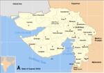
Districts Villages - Telnar
Topics - History
- Politics
- Government
- Economy
- Education
- People
- Culture
- Cuisine
- Geography
- National parks and sanctuaries
- Cinema
- Tourism
Major projects of Gujarat - Ahmedabad BRTS
- Gujarat International Finance Tec-City
- Sabarmati Riverfront Development Project
- Sardar Sarovar Project
- GSWAN
Regions of Gujarat - Bhal region
- Kathiawar region
- Gohilwad region
- Zhalawad region
- Charotar region
- Ghed region
Portal: Gujarat Categories:- Districts of Gujarat
- 1997 establishments in India
- Narmada district
- Gujarat geography stubs


Wikimedia Foundation. 2010.