- Deir al-Ghusun
-
Deir al-Ghusun Other transcription(s) – Arabic دير الغصون – Also spelled Deir al-Ghusoun (official)
Dayr al-Ghusoun (unofficial)Location of Deir al-Ghusun within the Palestinian territories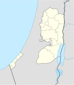
 Deir al-Ghusun
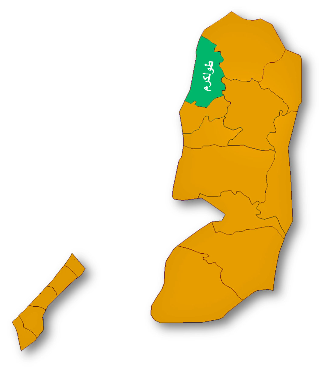
Coordinates: 32°21′11.15″N 35°04′37.08″E / 32.3530972°N 35.0769667°ECoordinates: 32°21′11.15″N 35°04′37.08″E / 32.3530972°N 35.0769667°E Governorate Tulkarm Government – Type Municipality (from 1997) – Head of Municipality Nasuh Badran Area – Jurisdiction 13,100 dunams (13.1 km2 / 5.1 sq mi) Population (2006) – Jurisdiction 9,460 Website www.deiralghusoon.com Deir al-Ghusun (Arabic: دير الغصون) is a Palestinian town in the Tulkarm Governorate, located eight kilometers northeast of the city of Tulkarm in the northern West Bank. The town is near the Green Line (border between Israel and the West Bank). The town had a population of 9,460 in 2006 and its altitude is 200 meters.
Contents
History
In the early 20th century, residents of Deir el-Ghusun established agricultural hamlets known as khirba, used mainly during the plowing and harvesting seasons, on the outskirts of the village. From the 1920s onwards, six of them became independent villages.[1]Before the establishment of the State of Israel, Deir al-Ghusun's jurisdiction encompassed the villages of Yama, Bir as-Sikka, al-Marja, and Ibthin, which in 1988 were merged to form the Israeli-Arab town Zemer.[2] The villages of Jarisha and Masqufa are located within Deir al-Ghusun but are governed by independent village councils.[3]
Land
During the 1948 Arab–Israeli War, 14,000 dunams were seized by Israel. Currently, its total land area is about 13,000 dunams of which 2,268 is built-up area.[4] Since the establishment of the Palestinian National Authority in 1994, the built-up area of the town increased by over 20% or an annual expansion of 34 dunams by 2000.[3] Agricultural land comprises 7,432 dunams, while the remainder is a part of the Seam Zone.[4]
Economy
Deir al-Ghusun was more prosperous than other Palestinian towns, however, the confiscation of substantial amounts of cultivable land east of the Green Line, the temporary sanctions against the Palestinian National Authority in 2006-2007, and the disruption of trade and transportation by Israeli West Bank Barrier has somewhat hampered the economy.[5] Agriculture constitutes 50-54% of the local economy,[3] and the town's main agricultural products are olive oil, citrus, melons, cucumbers and nuts.[5]
The commercial sector also provides for the town's residents, but is not very significant.[5] The service sector comprises 25% of the town's income.[3] A reservoir to supply the town with fresh water without the frustration of residents physically transporting water from Tulkarm was built in 2003 and replaced a dysfunctional older water tank, built in 1978.[6]
Demographics
According to the Palestinian Central Bureau of Statistics (PCBS), Deir al-Ghusun had a population of approximately 9,460 inhabitants in mid-2006.[7] In 1922, the town had a population of 1,259 and according to a census in 1945, the number of inhabitants rose to 2,220.[2][5] In the PCBS's first official census in 1997, the town had a population of 7,055 inhabitants including 660 refugees.[8] The gender makeup was 3,612 males and 3,443 females.[9]
Approximately 53% of Deir al-Ghusun's residents are within the employment age range (15-64) and females constitute a significant 48% of the local labor force. According to the municipal government, the town's economy was productive and steady in the post-First Intifada period, but decreased by 70% in 2001 at the beginning of the Second Intifada. The unemployment rate increased dramatically from 55% in 1999 to 80% after 2000. Approximately 51% of the households of the town have 1-5 family members, 43% have 6-10 members and 6% have more than 10 members. About 9% of the population in Deir al-Ghusun is illiterate and of this statistic, 83% are women.[3]
Salam Fayyad, the current Prime Minister and Finance Minister of the PNA was born in Deir al-Ghusun.
References
- ^ Transformation in Arab Settlement, Moshe Brawer, in The Land that Became Israel: Studies in Historical Geography, Ruth Kark (ed), Magnes Press, Jerusalem 1989, p.174
- ^ a b Tulkarm District Stats from Village Statistics of 1945: A Classification of Land and Area ownership in Palestine (1970) Hadawi, Sami. The Palestine Liberation Organization Research Center
- ^ a b c d e Spatial and Socioeconomic analysis at micro level: Deir al Ghusun, population, living conditions and urban trends Local Government Ministry of the Palestinian National Authority, Statistics obtained by Mayor of Deir al-Ghusun (Khaled Muhammad) and the Palestinian Central Bureau of Statistics. pp.11-13.
- ^ a b Closing of all the local agricultural roads in Deir Al Ghusun town Applied Research Institute-Jerusalem (ARIJ) and Land Research Center (LRC).
- ^ a b c d The city of Tulkarem and its villages:The town of Deir al-Ghusun (Arabic)
- ^ FOCUS Vol. 1 Tulkarm and Qalqilya: Keep the Water flowing in Deir al-Ghusun United Nations Development Programme. pp. 16-17.
- ^ Projected Mid -Year Population for Tulkarm Governorate by Locality 2004- 2006 Palestinian Central Bureau of Statistics.
- ^ Palestinian Population by Locality and Refugee Status: Tulkarm Governorate (1997 Census) Palestinian Central Bureau of Statistics.
- ^ Palestinian Population by Locality, Sex and Age Groups in Years (1997 Census) Palestinian Central Bureau of Statistics.
Cities 

Municipalities Anabta · Attil · Bal'a · Baqa ash-Sharqiyya · Beit Lid · Deir al-Ghusun · Dhinnaba · 'Illar · Kafr al-Labad · Qaffin · ZeitaVillages Far'un · Iktaba · Izbat Shufa · Al Jarushiya · Kafr Abbush · Kafr Jammal · Kafr Rumman · Kafr Sur · Kafr Zibad · Khureish · Kur · an-Nazla al-Gharbiya · an-Nazla ash-Sharqiya · an-Nazla al-Wusta · Nazlat Abu Nar · Nazlat 'Isa · Raml Zeita · Ramin · al-Ras · Saffarin · Seida · ShufaRefugee camps Categories:- Tulkarm Governorate
- Towns in the West Bank

Wikimedia Foundation. 2010.