- Billings, Montana
-
"Billings" redirects here. For other uses, see Billings (disambiguation).
Billings, Montana — City — Billings skyline with the Beartooth Mountains in the background.

Flag
SealMotto: Star of the Big Sky Country Location in Yellowstone County and Montana Location of the state of Montana in the United States
 Location in the United States
 Billings, Montana
Coordinates: 45°47′12″N 108°32′14″W / 45.78667°N 108.53722°WCoordinates: 45°47′12″N 108°32′14″W / 45.78667°N 108.53722°W Country United States State Montana County Yellowstone Founded 1877 Incorporated 1882 Government – Type Mayor-Council – Mayor Tom Hanel – City Admin. Christina "Tina" Volek – Governing body City Council Area – City 33.8 sq mi (87.6 km2) – Land 33.7 sq mi (87.3 km2) – Water 0.1 sq mi (0.3 km2) Elevation 3,123 ft (952 m) Population (2010 census)[1] – City 104,170 – Density 3,081.9/sq mi (1,047.0/km2) – Metro 158,050 Time zone Mountain (UTC-7) – Summer (DST) Mountain (UTC-6) ZIP codes 59101, 59102, 59103, 59104, 59105, 59106, 59107, 59108, 59109, 59110, 59111, 59112, 59113, 59114, 59115, 59116, 59117[2] Area code(s) 406 FIPS code 30-06550 GNIS feature ID 0802034 Highways 


Website www.cityofbillings.net Billings is the largest city in the U.S. state of Montana, and is the principal city of the Billings Metropolitan Area, the largest metropolitan area in over 500 miles (800 km). With a trade area of over half a million people[3] it is the largest metropolitan area between Denver and Calgary and between Sioux Falls, South Dakota, and Spokane, Washington.[4]
Billings is located in the south-central portion of the state and is the county seat of Yellowstone County, 2010 population of 147,972.[5] The 2010 Census put the Billings population at 104,170,[6] the only city in Montana to surpass 100,000 people.[7] The city is experiencing rapid growth and a strong economy; it has had and is continuing to have the largest growth of any city in Montana.[7] Billings has avoided the economic downturn that hit most of the nation as well as avoiding the housing bust.[8][9] With the Bakken oil play in eastern Montana and western North Dakota, the largest oil discovery in U.S. history,[10][11] as well as the Heath shale oil play just north of Billings,[12] the city's already rapid growth rate is expected to escalate.[13][14]
Billings was nicknamed the Magic City because of its growth from its founding as a railroad town in 1882. The city is named for Frederick H. Billings, a former president of the Northern Pacific Railroad. With one of the largest trade areas in the United States,[15] Billings is the trade and distribution center for most of Montana, Northern Wyoming and western portions of North Dakota and South Dakota. Billings is also the retail destination for much of the same area. With more hotel accommodations than any area within a five state region, the city hosts a variety of conventions, concerts, sporting events and other rallies.[15]
Area attractions include Yellowstone National Park, Pompey's Pillar, Little Bighorn Battlefield National Monument, Bighorn Canyon National Recreation Area, Pictograph Cave, Chief Plenty Coups State Park, Zoo Montana, Red Lodge Mountain Resort and the Beartooth Highway.
History
Before the city
 William Clark’s inscription on Pompeys Pillar
Much of Billings is located in the Yellowstone Valley, carved out by the Yellowstone River. Over 10 million years ago, this valley was underwater with the tops of the Rimrocks, 500-to-800-foot (150 to 240 m) cliffs to the north and east of downtown, being a prehistoric beach.[16] Some pictographs in the Pictograph Cave (Billings, Montana) 6 miles (9.7 km) south of Billings are 2,100 years old. The Pictograph, Middle, and Ghost cave complex were home to generations of prehistoric hunters. Approximately 30,000 artifacts, ranging from stone tools, weapons, paintings and the instruments used, have been identified from the site.[17] They were carved from the Eagle sandstone cliff by the forces of water and wind.[17] The Crow Indians frequented this area from about the year 1700. In 1806, William Clark traveled through the region on the Lewis and Clark Expedition. He inscribed his name on Pompey's Pillar, a rock formation 25 miles (40 km) northeast of Billings, on July 25, 1806 William Clark wrote that he climbed the sandstone pillar and "had a most extensive view in every direction on the Northerly Side of the river". Clark named the place "Pompys Tower" in honor of a young Shoshone boy he had nicknamed "Pompy." The boy's mother was Sacajawea, who had helped guide the Lewis and Clark expedition and had acted as an interpreter. The name of the formation was changed by 1814 to the current title. Clark's inscription is the only remaining physical evidence found along the route that was followed by the expedition.[18]
Coulson / Billings
Billings was established in 1882 in Montana Territory near the already existing town of Coulson. The city of Billings was a rail hub founded by the Northern Pacific Railroad on a site originally known as Clark's Fork Bottom. The location was steered by a plan to develop freight hauling up Alkali Creek to Ft Benton and beyond into the productive Judith and Musselshell Basins. This inauspicious location was three miles (5 km) from fresh water on the alkali flats above the Yellowstone River, and was far from an ideal location to start a town.[19]
The nearby town of Coulson, five years old and perched on the river's edge just to the northeast, appeared a far more likely site. Coulson was a rough and tumble town where arguments were often followed by gunplay. Coulson's first sheriff was none other than Liver-Eating Johnston.[20] Perhaps the most famous person to be buried in Coulsons Boothill cemetery is Muggins Taylor,[21] the scout who carried the news of Custer's Last Stand to the world. Most buried here were said to have died with their boots on. Settlers moving east from the Gallatin Valley had farmed the flats around Coulson since 1877, and rejoiced at the news that the railroad was coming their way. In the end, though, Billings edged out Coulson, to the great disappointment of those living in the settlement. The town of Coulson had been situated on the Yellowstone River, which made it ideal for the commerce that Steamboats brought up the river. However, when the Montana & Minnesota Land Company oversaw the development of potential railroad land, they ignored Coulson, and platted the new town of Billings just a couple of miles to the Northwest. Coulson quickly faded away; most of her residents were absorbed into Billings. Yet for a short time the two towns co-existed: a trolley even ran between the two. But ultimately there was no future for Coulson as Billings grew. Though it stood on the banks of the Yellowstone River only a couple of miles from the heart of present day Downtown Billings, the city of Billings never built on the land where Coulson once stood. Today Coulson Park sits along the banks of the Yellowstone where the valley's first town once stood.[19]
Early railroad town
Billings railroad ancestry is seen in its townsite configuration. Unlike mining towns of the region whose contours traced the haphazard routes of streambeds and ore bodies, railroad towns were orderly geometric affairs. Laid out on rectilinear grids, the rail lines formed the spine of the townsite, with streets for businesses and homes projecting away at right angles. Taking advantage of the unique way that Billings straddled two sections, Clark platted the town to include two main commercial streets, paralleling and fronting onto the rail line. These twin streets, named Montana and Minnesota for the mother company that gave them life, formed the commercial center of the new town.[19]
On April 1, 1882, Heman Clark arrived at Billings. Detailing the creation of the Billings townsite, what he described was basically an instant city planned to hold 20,000 inhabitants. Eight or nine sawmills, a 16-mile (26 km) irrigation system, rail spurs to nearby mines and money for the first bank in town came with the package. The railroad's promise to pump massive capital into the town "lit the fuse of a crazed land boom", and when M&MLI agent G. B. Hulme joined Clark the following week, the land rush was on.[19]
Meanwhile, work on the approaching NP line continued at breakneck pace. Henry Villard, then president of the NP, was pushing hard for the transcontinental connection. While rail crews built east from Portland, others continued west up the Yellowstone valley. In August 1882, the line was completed to Billings, and on September 8, 1883, spike-driving celebrations at Gold Creek, Montana forged the final link in the NP's chain across the continent.[19]
By May 1882, there were three buildings on the spot destined to become Billings. They were headquarters to lodge railroad survey crews, H. Clark's townsite office and mercantile, and a lone residence. Immediately, the building of town began. Many of the first structures were tents that sheltered hustling new businesses and town residents. Alongside them, cabins of rough-hewn log sprouted in about equal numbers and rapidly replaced the tents. By mid-June the first year, 79 tent shelters were in use, 81 houses were complete and another 75 homes were underway. Buildings to house new arrivals were hastily constructed south of the tracks, while commercial buildings and hotels were planted close to the hub of railroad activities. To keep order in the midst of the flurry, it was decreed that all dwellings be kept off the middle of streets[19]
The building boom continued, and by the end of 1883, the newspaper reported some 400 buildings, occupied by over 1,500 citizens. Maps of the day reveal that downtown encompassed about a nine-block area, split about evenly north and south of the railroad tracks. However, on the south the buildings were all of wood frame construction, while to the north, brick buildings were already beginning to edge out first generation frame buildings. Beyond downtown, the area south of the tracks became the first large residential neighborhood.[19]
On November 19, 1888, a visiting reporter described Billings' progress through her first half decade.
In January 1882, Billings was a bright prairie. Today it is a sprightly, live, energetic and aggressive town of 1,500 inhabitants. It has certain metropolitan characteristics such as a splendid system of water works, electric lights, graded streets, efficient fire department, excellent schools and churches, good society, an intelligent class of people, wide awake and quick to respond to any demands upon their purses in the interest of the community.[19]
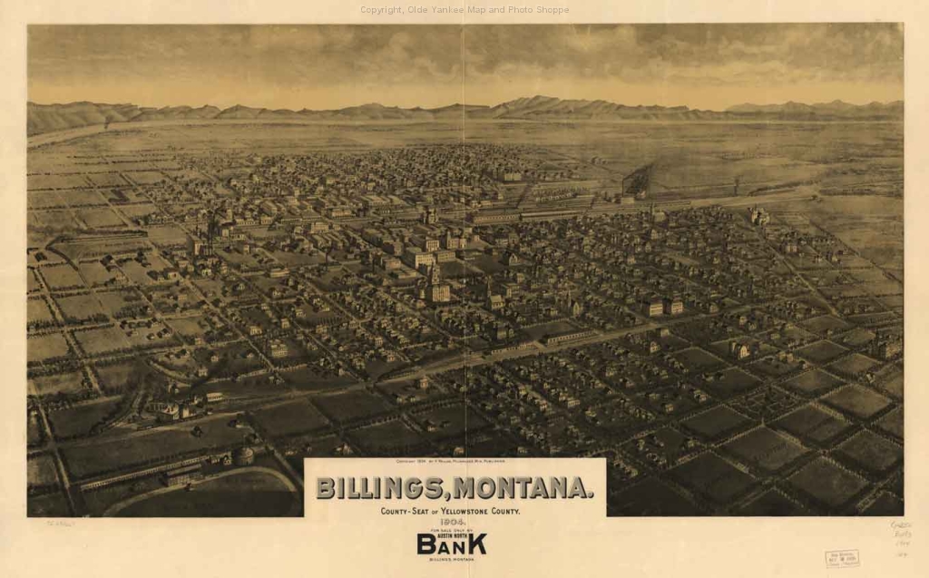
 Billings 1904
 Downtown Billings Post Office 1914
20th century
The railroad and the new townsite drew settlers from far and wide. Many of the new arrivals came from other countries (the 1900 census recorded a quarter of the population foreign-born), creating a cosmopolitan mix of people and cultures in early Billings. The Northern Pacific employed many Chinese on their rail crews, and many took up resident status in the new city of Billings. A police officer of the day remembered there were some 90 people, mainly "laundry and restaurant employees, born in China and with families still in China. The Chinese lived close together, primarily at the east end of the townsite near Minnesota Ave. Sam Lee, one of the most prominent Chinese businessmen, owned much of block 189 including the L & L Building which still stands at 2624 Minnesota Ave.[19]
In 1909, the Great Northern Railway built through Montana to Billings and beyond. That same year, Congress passed the Enlarged Homestead Act, allowing people to lay claim to 320 acres (1.3 km2) farms (double the previous size). What had been a steady flow of settlement suddenly became a raging torrent. In the heartland of dry farming, Billings was both a farm and rail hub. Outside of town, some 100,000 acres (400 km2) were put into cultivation, while greater Yellowstone County reported 2,500,000 acres (10,000 km2) dry were tilled for homestead farms.[19]
Banks abounded in Billings, each a monument to local prosperity. By 1905, there were six banks in town, with a combined capital of over half a million dollars. Downtown was transformed during this "modern" era, and buildings of the late 19th century gave way to new, larger buildings that reflected the prosperity of Billings in the early 20th century. The presence of the Burlington and Milwaukee Railroad along the 5th Avenue North right-of-way drew downtown development that direction, and northern portions of downtown became increasingly urban. On March 24, 1909, a new downtown "Union Depot" serving the NP, Great Northern and Burlington lines opened to the public. Hotels large and small sprouted at the heart of downtown to serve travelers to Billings. Most prominent were the Northern and the Grand Hotels. Both buildings remain today, and are commanding on the Billings skyline. Smaller hotels also grew up in the shadow of the depot. Along Montana in the depot district, several small hotels were erected during the second decade of the 20th century. The Eagle, McCormick, Rex, Lincoln and Carlin are among those buildings that still remain.[19]
By the 1910 census, Billings' population had risen to 10,031 ranking it the sixth fastest growing community in the nation.[19] In 1911, a new Federal Building at First Ave. North and North 26th St. was begun. Completed in January 1914, it housed the post office, courthouse, and a booming U.S. Land Office. In 1912, the Montana Power Company constructed the Electric Building, aglow at night with recessed panel lighting. In May 1918, the Hart-Albin Building was completed and opened for business at Broadway and Second Ave. North.[19]
 Panoramic view of downtown Billings 1915.
Homes and older commercial buildings in the way of the boom were quick to go. At the same time, desirable neighborhoods rose up on the edge of the expanding downtown. A stone mansion and carriage house ("The Castle") built by Austin North in the 600 block of North 29th St. helped to set the pace in this fashionable northern part of town. On the western side of town, P.B. Moss built a red stone house on Division,[22] and I.D. O'Donnell built a large new home at First St. West and Clark St. in 1904.[19]
Toward the end of the homestead boom, oil production began on the outskirts of town. The Elk Basin oil field on the Montana-Wyoming border was located in mid-1915, and by the following year, the first well near Billings was drilled. Soon the Montana-Wyoming Oil Journal was in print to report on the latest developments from the oil fields. Just 6 years later, natural gas was also discovered in the basin, and plans for a pipeline to the city were discussed. In the 1940s and 1950s, this industry helped pull Billings into a new era and became a lynchpin of the local economy.[19]
After World War II, Billings boomed into the major financial, medical and cultural center of the region. Billings always experienced rapid growth from its founding, in its first 50 years growth was at times in the 300 and 400 percentile.[23] Billings's growth has remained robust throughout the years and at times almost unmanageable as in the 1950s when it had a growth rate of 66.0%. The 1973 oil embargo by OPEC spurred an oil boom in eastern Montana, northern Wyoming and Western North Dakota. With this increase in oil production, Billings became the headquarters for energy sector companies. In 1975 and 1976, the Colstrip coal fire generation plants 1 and 2 were completed; plants 3 and 4 were operational in 1984 and 1986.
In the 1970s and 1980s, Billings saw major growth in its downtown core; the first high-rise buildings to be built in Montana were erected. In 1980, the 22-floor Sheraton Hotel was completed. At the time, it was the tallest building from Minneapolis, Minnesota to Seattle, Washington and from Denver, Colorado to Calgary, Alberta (Canada). Upon its completion it was also declared "the tallest load-bearing brick masonry building in the world" by the Brick Institute of America.[24] During the 1970s and 1980s, Billings also saw the completion of other important buildings in its downtown core;[25] the Norwest Building (now Wells Fargo), Granite Tower, Sage Tower the MetraPark arena, the TransWestern Center, many new city owned parking garages and the First Interstate Tower, now the tallest building in a five state area.[26]
With the completion of large sections of the interstate system in Montana in the 1970s, Billings became an even bigger shopping destination for an ever increasingly larger area. The 1970s and 1980s saw new shopping districts and shopping centers developed in the Billings area. In addition to the other shopping centers developed, two new malls were developed and a third mall redeveloped and enlarged, Rimrock Mall on what was then the city's west end, Cross Roads Mall, no longer in existence, in Billings Heights, and West Park Plaza mall in midtown. In addition, several new business parks were developed on the city's west end during this period. Billings was affected by the 1980 eruption of Mount St. Helens in May; the city received about an inch of ash on the ground.[27] The Yellowstone fires of 1988 blanketed Billings in smoke for weeks.[28]
 Downtown Billings.
In the 1990s, Billings saw further enlargement of its service sector with the arrival of new shopping centers built around stores such as Target, Wal Mart and Office Depot, all of which built multiple outlets in the Billings area. With the addition of more interchange exits along I-90, even more hotel chains and service industry outlets are being built in Billings. Development of more business parks and large residential developments on the city's west end, South Hills area Lockwood and the Billings Heights were all part of the 1990s. Billings received the All-America City Award in 1992.
 First Interstate Tower downtown Is the tallest building from Denver to Calgary, Alberta, Canada and from Minneapolis to Spokane.[29]
21st century
In the 21st century, Billings saw the development of operations centers in the city's business parks and downtown core by such national companies as GE, Wells Fargo and First Interstate Bank. It also saw renewed growth in the downtown core with the addition of numerous new buildings, new parking garages and a new MET Transit Center and in 2002 Skypoint was completed. Downtown also saw a renaissance of the historic areas within the downtown core as building after building was restored to its previous glory. In 2007, Billings was designated a Preserve America Community.[30] With the completion of the Shiloh interchange exit off Interstate 90, The TransTech Center was developed[31] and yet more hotel development as well. In 2010 the Shiloh corridor was open for business with the completion of the Shiloh parkway, a 4.8-mile (7.7 km) multi-lane street with eight roundabouts.[32] Even more shopping centers were developed in the 21st century. Some of the new centers are Shiloh Crossing which brought the first Kohl's[33] department store to Montana, Billings Town Square with Montana's first Cabela's,[34] and West Park Promenade, Montana's first open-air shopping mall. In 2009, Fortune Small Business magazine named Billings the best small city in which to start a business.[3][35] Billings saw continued growth with the largest actual growth of any city in Montana. On June 20, 2010 (Father's Day), a tornado, dubbed by the media the Fathers Day Tornado,[36][37] touched down in the downtown core and Heights sections of Billings. The Rimrock Auto Arena at MetraPark and area businesses suffered major damage. While the nation has been feeling the effects of a recession, Billings's economy has been strong. Construction and housing starts have been up has well as large investments in the community by national companies and major new road construction projects. The state's economy is healthier than most states but as western Montana is suffering from a crash in real estate and the near demise of its timber industry, eastern Montana and North Dakota are experiencing an energy boom due to coal and the Bakken formation the largest oil discovery in U.S. history.[10][11][14] Billings is Montana's oasis of economic growth.[3][38]
Geography
 The Rims border the north and east edges of the downtown core
Billings is located at 45°47′12″N 108°32′14″W / 45.78667°N 108.53722°W (45.786553, -108.537139)[39], with two-thirds of the city being in the Yellowstone Valley and the South Hills area and one-third being in the Heights-Lockwood area. The city is divided by the Rims, long cliffs, also called the Rimrocks. The Rims run to the north and east of the downtown core, separating it from the Heights to the north and Lockwood to the east, with the cliffs to the north being 500 feet (150 m) tall and to the east of downtown, the face rises 800 feet (240 m). The Yellowstone River runs through the southeast portion of the city. According to the United States Census Bureau, the city has a total area of 33.8 square miles (87.6 km²), of which 33.7 square miles (87.3 km²) is land and 0.1 square mile (0.3 km²) (0.33%) is water. Around Billings, six mountain ranges can be viewed, the Bighorn Mountains, Pryor Mountains, Beartooth Mountains, Crazy Mountains, Big Snowy Mountains and the Bull Mountains.
Climate
Billings has a semi-arid climate (Koppen BSk),[40] with hot summers, and cold, dry winters. In the summer, the temperature can rise to over 100 °F (38 °C) (1 to 3 times per year)[41][42] while the winter can bring temperatures below zero (-17°C), with 17 to 18 such nights per year.[41] The snowfall averages about 57 inches a year, but because of warm Chinook winds that pass through the region between December and March, the snow does not usually accumulate heavily or remain on the ground for long. First frosts generally come early (late September to early October) and last frosts (late April to early May) late.[41] Spring and autumn in Billings are usually mild, but brief. Winds, while strong at times, are considered light compared with the rest of Montana and the Rocky Mountain front.
Climate data for Billings, Montana (Billings Airport) Month Jan Feb Mar Apr May Jun Jul Aug Sep Oct Nov Dec Year Average high °F (°C) 32.8
(0.4)39.5
(4.2)47.6
(8.7)57.5
(14.2)67.4
(19.7)78.0
(25.6)85.8
(29.9)84.5
(29.2)71.8
(22.1)58.9
(14.9)42.7
(5.9)34.5
(1.4)58.4 Average low °F (°C) 15.1
(−9.4)20.1
(−6.6)26.4
(−3.1)34.7
(1.5)44.0
(6.7)52.5
(11.4)58.3
(14.6)57.3
(14.1)47.1
(8.4)37.2
(2.9)25.6
(−3.6)17.7
(−7.9)36.3 Precipitation inches (mm) .81
(20.6).58
(14.7)1.12
(28.4)1.74
(44.2)2.48
(63)1.89
(48)1.28
(32.5).85
(21.6)1.34
(34)1.26
(32).75
(19.1).67
(17)14.77
(375.2)Snowfall inches (cm) 10.3
(26.2)6.5
(16.5)10.3
(26.2)7.7
(19.6)1.8
(4.6)0
(0)0
(0)0
(0)1.3
(3.3)4.2
(10.7)7.5
(19.1)8.2
(20.8)57.8
(146.8)Avg. precipitation days (≥ 0.01 in) 8.0 6.9 9.3 10.7 12.0 11.0 8.1 6.6 7.2 6.8 6.3 7.2 100.1 Avg. snowy days (≥ 0.1 in) 7.2 6.2 7.2 4.3 .8 0 0 0 .5 2.2 4.8 7.2 40.4 Sunshine hours 130.2 158.2 235.6 255.0 282.1 306.0 356.5 328.6 255.0 204.6 129.0 117.8 2,758.6 Source no. 1: NOAA (1971-2000)[41] Source no. 2: HKO (sun only, 1961-1990)[43] Climate data for Billings, Montana (downtown) Month Jan Feb Mar Apr May Jun Jul Aug Sep Oct Nov Dec Year Record high °F (°C) 75
(24)76
(24)82
(28)92
(33)99
(37)108
(42)112
(44)107
(42)100
(38)95
(35)80
(27)75
(24)112
(44)Average high °F (°C) 37.3
(2.9)44.2
(6.8)53.2
(11.8)62.7
(17.1)71.7
(22.1)81.1
(27.3)88.4
(31.3)87.8
(31.0)77.1
(25.1)65.3
(18.5)47.9
(8.8)39.1
(3.9)63.0 Average low °F (°C) 13.3
(−10.4)18.3
(−7.6)25.4
(−3.7)33.8
(1.0)43.1
(6.2)51.2
(10.7)56.2
(13.4)54.8
(12.7)44.9
(7.2)35.3
(1.8)24.0
(−4.4)15.8
(−9.0)34.7 Record low °F (°C) −39
(−39)−49
(−45)−34
(−37)−5
(−21)14
(−10)26
(−3)37
(3)28
(−2)18
(−8)−11
(−24)−28
(−33)−41
(−41)−49
(−45)Precipitation inches (mm) .62
(15.7).49
(12.4).87
(22.1)1.55
(39.4)2.39
(60.7)1.98
(50.3)1.19
(30.2).92
(23.4)1.42
(36.1)1.32
(33.5).64
(16.3).57
(14.5)13.96
(354.6)Avg. precipitation days (≥ 0.01 in) 6.3 4.5 5.9 7.5 9.4 9.7 6.0 5.3 6.0 5.9 4.9 5.1 76.5 Source: NOAA (normals 1971-2000, extremes 1894-2001)[42] Severe weather
Although far from Tornado Alley, Billings is not immune from severe weather, but tornadoes are very rare in Billings. In most cases, severe storms travel fast at 25 to 30 miles per hour and either veer to the north or south of the city. The first recorded tornado to touch down in Billings was on June 2, 1958. On June 20, 2010, a tornado dubbed the Fathers Day Tornado[36][37] touched down in the Billings Heights and Downtown sections of the city. The tornado was accompanied by hail up to golf ball size, dangerous cloud to ground lightning, and heavy winds. The tornado destroyed a number of businesses and severely damaged the 12,000-seat Rimrock Auto Arena at MetraPark.[44]
Demographics
Population
Historical populations Census Pop. %± 1870 145 — 1880 587 304.8% 1890 836 42.4% 1900 3,211 284.1% 1910 10,031 212.4% 1920 15,100 50.5% 1930 16,386 8.5% 1940 23,216 41.7% 1950 31,834 37.1% 1960 52,851 66.0% 1970 61,581 16.5% 1980 66,798 8.5% 1990 81,151 21.5% 2000 89,847 10.7% 2010 104,170 15.9% Source:[45][46] The 2010 Census recorded Billings' population at 104,934 with a population density of 3,080.9 per square mile (1,047.0/km2).[1]
According to the 2010 Census, the city's population was 89.6% White (86.9% Non-Hispanic White alone), 0.8% Black or African American, 4.4% American Indian and Alaska Native, 0.7% Asian, 0.1% Native Hawaiian and Other Pacific Islander, 1.4% from Some Other Race and 2.9% from Two or More Races. Hispanics and Latinos of any race made up 5.2% of the population. [47]
There were 37,525 households out of which 29.2% had children under the age of 18 living with them, 47.2% were married couples living together, 10.8% had a female householder with no husband present, and 38.3% were non-families. 31.3% of all households were made up of individuals and 11.4% had someone living alone who was 65 years of age or older. The average household size was 2.32 and the average family size was 2.93.
In the city, the population was spread out with 24.0% under the age of 18, 10.1% from 18 to 24, 28.7% from 25 to 44, 22.3% from 45 to 64, and 14.8% who were 65 years of age or older. The median age was 37 years. For every 100 females there were 92.7 males. For every 100 females age 18 and over, there were 88.8 males.
The median income for a household in the city was $35,147, and the median income for a family was $45,032. Males had a median income of $32,525 versus $21,824 for females. The per capita income for the city was $19,207. About 9.2% of families and 12.0% of the population were below the poverty line, including 16.5% of those under age 18 and 7.0% of those age 65 or over. 29.4% of the population had a Bachelor's degree or higher.[48]
Sections
 Tree lined streets on a late summer day Downtown
Billings has many sections that comprise the whole of the city. Because of the unique geography of Billings many of these sections are defined by actual physical characteristics of the terrain. For example; the Heights is separated from Downtown by a 500-foot (150 m) cliff known as the (Rims).
Main article: Sections of Billings, MontanaThere are currently 10 official first level of districts called "sections" within the city limits of Billings, Montana.
Neighborhoods and zones
The city's neighborhoods make up the soul of Billings. The south side of Billings is probably the oldest residential area in the city, and it is the city’s most culturally diverse Neighborhood. South Park is an old growth City park, host to countless food fairs and festivals in the summer months. The Bottom Westend Historic District is home to many of Billings first mansions. Mid-town, the most densely populated portion of the city is in the midst of gentrification on a level that few if any areas in Montana have ever seen. Or even Josephine Crossing, one of Billings' many new contemporary neighborhoods.
Main article: Neighborhoods and Zones of Billings, MontanaSuburbs and communities of the Billings Metro Area
Billings is surrounded by many incorporated and unincorporated communities, which make up the Billings Metropolitan Area. They include Laurel, Lockwood, Shepherd, Huntley, Worden, Pompey's Pillar and Ballantine all in Yellowstone County. In Carbon County are Red Lodge, Bridger, Joliet, Bearcreek, Belfry, Fromberg, Boyd, Edgar, Fox, Luther, Roberts, Rockvale, Roscoe, Silesia and Washoe.
Main article: Suburbs of Billings, MontanaGovernment
City Council:[49] Mayor Tom Hanel Ward 1 Peggie Denney Gaghen / Jim Ronquillo Ward 2 Angela Cimmino / Denis Pitman Ward 3 Richard McFadden / Vince Ruegamer Ward 4 Jani McCall / Ed Ulledalen Ward 5 Richard (Dick) Clark / Mark Astle Main article: Billings, Montana Government and PoliticsBillings is governed via the mayor council system. There are ten members of the city council who are elected from one of five wards with each ward electing two members. The mayor is elected in a citywide vote. The current city charter, also called the Billings, Montana City Code (BMCC) was established 1977.
Main article: Mayors of Billings, MontanaPublic safety
The Billings Police Department is the main law enforcement agency in Billings. It is the largest city police force in Montana, with about 136 sworn officers and 80 civilian employees. There are nine police beats.
The Billings Fire Department provides emergency services including fire suppression, emergency medical response, hazardous materials response, high angle rescue, confined space rescue, vehicle accident extrication, fire investigations, fire inspections, and fire education. The department has 97 employees, including four battalion chiefs, 27 captains, 27 engineers, and 39 firefighters.
American Medical Response (AMR) provides emergency medical services at the paramedic care level in Billings, and supports other agencies throughout Yellowstone County.
The tallest buildings in Montana
List of tallest buildings in Billings. The tallest buildings in Montana and a five state region are in Billings. This is a list of the ten tallest buildings in the city.[50][51]
 The Crowne Plaza Downtown
Economy
The geographic location of Billings was essential to its economic success. It is the center of a large area, bordered by Minneapolis, Minnesota to the east and Seattle, Washington to the west, Calgary, Alberta (Canada) to the north and Denver, Colorado to the south.[53] Billings' future as a major trade and distribution center was basically assured from its founding as a railroad hub due to its geographic location. As Billings quickly became the region's economic hub it outgrew the other cities in the region. Billings trade area is geographically one of the largest trade areas in the United States.[53] The Billings trade area serves over a half million people.[3][53] A major trade and distribution center, the city is home to many regional headquarters and corporate headquarters.[53] With Montana having no sales tax, Billings is a retail destination for much of Wyoming, North and South Dakota as well as most of Montana.[53] Billings is an energy center; Billings sits amidst the largest coal reserves in the United States as well as large oil and natural gas fields.[53]
 Foreground: The Historic Grand Building Downtown
In 2009, Fortune Small Business magazine named Billings the best small city in which to start a business.[35] Billings has a diverse economy including a large and rapidly growing medical corridor that includes inpatient and outpatient health care. Billiings has a large service sector including retail, hospitality and entertainment. The metro area is also home to 3 oil refineries, a sugar beet refining plant, a coal fire generation plant, commercial and residential construction, building materials mfg and distribution, professional services, financial services, banking, trucking, higher education (4 campuses, 19 others have a physical presence/classes here), auto parts wholesaling and repair services, passenger and cargo air, cattle, media, printing, wheat and barley farming, sugar beet refining, milk processing, heavy equipment sales and service, business services, consumer services, food distribution, ag chemical mfg and distribution, energy exploration and production, surface and underground mining, metal fabrication, and many others providing a diverse and robust economy.
Corporate headquarters include Stillwater Mining Company, Kampgrounds of America, First Interstate Bank, Computers Unlimited, Tire-Rama, Western Plains Machinery, Tractor & Equipment Co., Bresnan Communications, Corporate Air, Employee Benefits Management Services, Edwards Jet Service, Waggoners Trucking, Meadowlark Agency, Ryan Restaurant Corp., CTA Architects & Engineers, JGA Architects, HKM Engineering, Electrical Consultants Inc. engineering, Unifield Engineering, Energy Labs, and others.[54] Fortune 500 firms with branch operations in Billings include Exxon/Mobil, Wal-mart, GM, Conoco-Phillips, Ford, Wells Fargo, General Electric, USBank, Travelers, BNSF, Pennsylvania Power & Light, MDU Resources, Sears/K-Mart, Target Corporation, New York Life, Morgan Stanley.[54]
Transportation
 United Shuttles at the Airport
Airports
Because of Billings' unique geography, Billings Logan International Airport is located just moments from the heart of downtown; it sits on top of (the Rims), a 500-foot (150 m) cliff overlooking the downtown core. Billings Logan International Airport is the largest and busiest airport within a four state region (Montana, Wyoming, North and South Dakota) both in passenger boardings and air cargo.[55]
The Laurel Municipal Airport is a publicly owned public-use airport in Laurel, Montana, which is located eleven miles (17 km) southwest of the central business district (CBD) of Billings, Montana. The airport has three runways exclusively serving privately operated general aviation aircraft and helicopters.[56]
Public Transportation
The Billings METropolitan Transit is the public transit system in Billings. MET Transit provides fixed-route and paratransit bus service to the City of Billings. All MET buses are accessible by citizens who use wheelchairs and other mobility devices. They are wheelchair lift-equipped and accessible to all citizens that are unable to use the stairs. MET buses are equipped with bike racks for their bike riding passengers.[57] There are also numerous Taxicab and Limousine services within the city.[58] The Billings Bus Terminal is served by Greyhound has well as Rimrock Trailways which also provides regional and interstate bus service.[59][60]
Biking / Walking
Billings has an extensive system of Bike trails. The Heritage Trail System includes a network of non-motorized multi-use trails and biking facilities within the greater Billings area. The City has a variety of multi-use trails and open spaces available for Walking, jogging, biking, or inline skating. The rapidly expanding system is being developed and maintained by the Billings Parks and Recreation Department.[61]
Bicycling magazine ranked Billings among the nation's 50 most bike friendly communities ranking above cities like Salt Lake City, St. Louis, Miami, and Baltimore.[62]
Roads
Interstate 90 runs east/west through the southern portion of Billings, serving as a corridor between the Heights, Lockwood and Downtown, South Hills, Westend, Shiloh, and Laurel. East of Downtown, between the Heights and Lockwood, Interstate 90 connects with Interstate 94 which serves as an east/west corridor between Shepherd, Huntley and Heights, Lockwood, Downtown, South Hills, Westend, Shiloh, Laurel via its connection with I-90.
U.S. Highway 87 is a north/south highway that runs along the edge of the North Rims Connecting Downtown and the Westend with the Rehberg Ranch, Indian Cliffs and the Heights. It turns into Main Street in the Heights before connecting to U.S. Highway 87 East which runs through Lockwood as Old Hardin Road.[63]
Some major streets in the Billings valley include Zoo Drive, Gabel Road, Overland Av, Neibauer Road, Hesper Road, King Avenue West, King Avenue East, Monad Road, Central Avenue, Broadwater Avenue, Grand Avenue, Poly Drive, Rimrock Road, 64th Street West, 62nd Street West, 58th Street West, 54th Street West, 48th Street West, Shiloh Road, Zimmerman Trail/32nd Street West, 24th Street West, 19th Street West/20th Street West, 16th Street West, 15th Street West, 8th Street West, 6th Street West, 5th Street West, Moore Lane, State Av, Laurel Road, Billings Blvd, Calhoun Lane, Southgate Drive, Midland Road, Mullowney Lane, South Frontage Road, Hollowell Lane, Jackson Street, Sugar Av and Garden Av.[63]
Some major Streets in the South Hills include Blue Creek Road, Hillcrest Road, and Briarwood Blvd.[63]
Some of the major streets Downtown include Division, 30th, 29th, Broadway, 27th, 26th, 25th, 24th, 13th, Exposition, 1st Av South, Minnesota Av, Montana Av, 1st Av North, 2nd Av North, 3rd Av North, 4th Av North, 6th Av North, 9th Av North, 12th Av North, Poly, and Rimrock.[63]
Some of the major Streets in the Heights include Airport Road, Alkali Creek Road, Aronson Av, Hilltop Road, Lake Elmo Road, Governors Blvd, Senators Blvd, Wicks Lane, Main Street, Bench Blvd, and Yellowstone River Road.[63]
Medical facilities
The Billings Metro Area has two Level II trauma hospitals, St. Vincent Healthcare and the Billings Clinic which is the largest cluster of medical facilities between Salt Lake, Denver, Boise, Lethbridge, Rapid City, and Fargo. Employs over 5,000 directly. Neurosurgery, highly rated cardiac surgery, neonatology and obstetrics, extensive cancer treatment, inpatient psychiatric care, orthopedics and rehab, dedicated air ambulances both fixed-wing planes and helicopters.
Other medical facilities include the Northern Rockies Radiation Oncology Center, Rimrock Foundation (addiction treatment both inpatient and outpatient), Advanced Care Hospital of Montana (a 40-bed long term acute care hospital), South Central Montana Mental Health Center, Billings VA Community Based Outpatient Clinic, Billings Clinic Research Center (pharmaceutical field trials, osteoporosis are two long-time focuses), Billings MRI, City/County Public Health's Riverstone Health, HealthSouth Surgery Center and Physical Therapy offices, Baxter/Travenol BioLife plasma collection center, and many independent practices.
An increasing number of assisted living facilities and senior independent living options, a static number of nursing homes, and sizable home health care services target the rapidly growing aging population, already 1 in 8 Montanans are over 65 making it the 4th "oldest" state in the U.S. after Florida, Arizona, and Wyoming.
Billings campuses train physician assistants, biochemists, paramedics, registered nurses, speech pathologists, licensed practical nurses, surgical technicians, x-ray technicians, medical records clerks, athletic trainers, and health care business students at the undergraduate and graduate level as of 2007.
Education
Public
The city of Billings operates 22 elementary schools in district 2. The elementary schools are Alkali Creek, Arrowhead, Beartooth, Bench, Big Sky, Bitterroot, Boulder, Broadwater, Burlington, Central Heights, Eagle Cliffs, Highland, McKinley, Meadowlark, Miles Avenue, Newman, Orchard, Poly Drive, Ponderosa, Rose Park, Sandstone, and Washington. There is also a district 3 in Billings, which only contains the elementary school Blue Creek and a district 8, which contains Elder Grove School,[64] teaching grades K - 8. The four middle schools in Billings are Riverside Middle School, Lewis and Clark, Will James, and Castle Rock. There are three high schools as well, including Billings Senior High, West High, and Skyview.
Private
- The Billings Catholic Schools operates Billings Central Catholic High School (grades 9-12), St. Francis Upper (grades 6-8), St Francis Intermediate (grades 3-5), St Francis Primary, (K-2) and St Francis Daycare
- Trinity Lutheran Church operates Trinity Lutheran School, serving grades K-8
- Billings Christian Schools serving grades K-12
- Adelphi Christian Academy serving grades K-12 (Closed at the end of the 2009 School Year)[65]
- Billings Educational Academy serving grades K-12
- Grace Montessori Academy serves Pre-6[66]
Colleges and universities
There are several institutions of higher learning in Billings. These include state schools (Montana State University Billings and the MSU Billings College of Technology) and private schools (Rocky Mountain College and Yellowstone Baptist College).
 McMullen Hall, Montana State University Billings
Montana State University Billings was originally named Eastern Montana Normal School when it was founded and then named Eastern Montana College before being renamed to its present name when the Montana State University System reorganized in 1994. The university was established in 1927 and offers Associate/Bachelor/Master degrees and certificates in various education fields. Currently around 5,000 students attend MSU Billings.
MSU Billings College of Technology (West campus) was originally a vocational-technical school associated with the Billings School District. Now as a college of Montana State University Billings, the COT offers associate-level degrees, entry into the four year programs as well as community college programming. In the past few years, enrollment has risen to over 1,200 full time students (accounting for nearly 1/5 of the student body). Projections with grant improvements and workforce needs foresee a 2,000 student increase in the near future and the evolution into a comprehensive community college.
Billings also offers two private schools. Rocky Mountain College is Montana's oldest and first institution of higher learning, founded in 1878. It is a private comprehensive college offering over 40 liberal arts and professionally oriented majors. Rocky Mountain College is often simply called "Rocky" or "RMC" for short. Rocky is proud of its standing record of being ranked by U.S. News & World Report as one of the top 10 in quality and a “best value” among comprehensive colleges in the West. Along with its quality Rocky also continues to maintain a 99% graduate placement rate. Yellowstone Baptist College also offers a limited curriculum.
Culture
Arts
 Deborah Butterfield Sculpture - Captain
- Alberta Bair Theater
- Babcock Theatre
- Billings Studio Theater
- Billings Symphony Orchestra
- Rimrock Opera Company
- Venture Theatre
- Yellowstone Art Museum
- Yellowstone Chamber Players
- Yellowstone County Museum
- Western Heritage Center
Recreation/events

 The Palisades area on the north end of the ski area at Red Lodge Mountain Resort
 disc golf Basket. Billings has some of the best disc golf courses around
Activities in and around Billings include hiking, rock climbing, mountain climbing, fishing, skiing, boating, disc golf, skateboarding, the Downtown Skateboard Park, motorcycle trials, golf, mountain biking, rappelling, extensive walking and bike trails, art walks, concerts, food fairs and rodeos. Some annual events include:
- Wine & Food Festival at MSU Billings: May
- Strawberry Festival under Skypoint: June
- SummerFair at North Park: July
- 4 July Parade in Laurel, Montana: July
- Gay Pride Weekend
- Alive After 5 concerts: Thursdays June - September
- Battle of the Little Big Horn Re-enactment near Crow Agency, Montana: June
- Farmers Market under Skypoint: Every Saturday June to October
- Big Sky State Games - July
- Great American Championship Motorcycle Hill Climb
- Skyfest (Hot air balloons): July/August
- MontanaFair at the MetraPark fairgrounds: August 13–21[71]
- Magic City Blues Festival: August in Downtown Billings
- Crow Fair & Rodeo in Crow Agency, Montana: August
- Burn the Point (classic car show): September in Downtown Billings
- Harvest Fest: October
- Christmas Parade in Downtown Billings: November 24
- Festival of Trees: December
- The Christmas Stroll in Downtown Billings: December
- Billings Artwalk
Media
Main article: Billings, Montana MediaBilings is the largest media Market in Montana and Wyoming. Billings is serviced by a variety of print media. Newspaper service includes The Billings Gazette[72] which is a daily morning broadsheet newspaper printed in Billings, Montana and owned by Lee Enterprises. It is the largest daily newspaper in Montana, with a Sunday circulation of 52,434 and a weekday circulation of 47,105. The paper publishes in three editions: the state edition, which circulates in most of Eastern Montana and all of South Central Montana; the Wyoming edition, which circulates in Northern Wyoming; and the city edition, which circulates in Yellowstone County. Other publications include the Billings Outpost,[73] a weekly publication, and the alternative publication The Grindstone,[74] which is published monthly. As well as other more specialized weekly and monthly publications, Billings also has several community magazines amongst them are Magic City Magazine[75] and Yellowstone Valley Woman.[76]
The Billings area is served by four major non-news television stations, two major news television stations, one community television station, four PBS chanels[77] and several Low Power Television (LPTV) channels. The Billings area is also served by twenty-two commercial radio stations and Yellowstone Public Radio (NPR).[78]
Attractions
 Old Faithful, Yellowstone National Park
Attractions located within Billings include the Yellowstone Art Museum, Moss Mansion Historic House Museum, the Western Heritage Center, the Billings Depot, and Skypoint.
- The Moss Mansion Historic House Museum is located in Billings on 914 Division St. It is a turn of the century, red-stoned mansion built in 1903 by P.B. Moss, who moved to Billings from Paris, Missouri. It was inhabited solely by Mr. and Mrs. Moss, their six children, and three servants.[22] The house was built for a cost of $105,000, when most homes averaged about $3,000. It has 28 rooms, and is 60 feet (18 m) square. It rises 45 feet (14 m) into the air. The Mansion is listed on the National Register of Historic Places. Visitors can still see the original furniture, draperies, carpets and fixtures during a one-hour guided tour. Seasonal exhibits are also featured. The Moss Mansion was designed by the famous New York Architect Henry Hardenbergh, who also designed the original Waldorf-Astoria, Plaza Hotel, Willard Hotel, and Copley Hotel. The Moss Mansion is operated by the Billings Preservation Society, Inc., a non-profit organization.[22]
 Yellowstone Park - Lower Falls
- Western Heritage Center: Downtown attractions include the Western Heritage Center Museum which is located in the historic Parmly Billings Library building on Montana Avenue in the downtown Historic District. The Parmly Billings library, a Richardsonian Romanesque sandstone building built in 1901, is listed on the National Register of Historic Places. This regional museum interprets a unique collection of artifacts and oral histories that document the history of the Yellowstone River Valley and the Northern High Plains. The Western Heritage Center is an affiliate museum of the Smithsonian Institution. The Western Heritage Center is one of six museums in the state of Montana accredited by the American Association of Museums.[79]
- Downtown Historic District: In 1977, the Billings City Council created the Billings Historical District: Montana Avenue from North 26th Street to North 22nd and north to First Avenue North. In 1978, the Historic District has was entered into the National Register of Historic Places. The Northern Pacific Billings Depot or simply the Billings Depot is a cornerstone of the Historic District. The arrival of the railroad in 1882 signaled the real beginning of Billings. Designed in the Beaux Arts Eclectic style, the four original buildings included the Depot building, railroad lunchroom, mail building and an office building. The Depot featured a spacious waiting area for 200 passengers, a gentlemen's smoking room, a ladies' waiting room, a baggage area and service offices. Today, the Depot is used as an events center hosting a wide variety of events.[80]
 Little Bighorn Battlefield
- Boothill Cemetery: is a burial ground for Coulson Montana, a rough cow town that presided Billings. Coulson stood on the banks of the Yellowstone river about two miles (3 km) from present day downtown Billings. Most of the people buried here were said to have died with their boots on. The cemetery was started when one gent in a Coulson saloon called another a liar. Nearly all of those interred at Boothill met with violent deaths. The most famous person to be buried here is Muggins Taylor, the scout who carried the news of Custer's Last Stand to the world. The last burial at Boothill was in 1882. Today, Boothill is at the base of Swords Park and just off of Main Street in Billings Heights, the busiest street in Montana.[81]
 Pompeys Pillar National Monument
 pictograph cave historic landmark
- Black Otter Trail is a scenic drive just off of Airport Road, U.S. 318. The road passes Boothill Cemetery, climbs Kelly Hill and winds through Swords Park a large city park in the center of the City. The park is on the edge of the Rimrocks, 500-foot (150 m) cliffs that divide the downtown area from Billings Heights. Black Otter Trail is named after a Crow chief who was killed here by a Sioux war party. He was given a treetop burial on a site overlooking the Yellowstone River.[81]
- Yellowstone Kelly’s Grave is a monument to Yellowstone Kelly, who lived from 1849 to 1928. Kelly was the epitome of a frontiersman, army scout, dispatch rider, and hunter. At his own request, he was buried on Kelly Hill which is near the edge of the Rimrocks in Swords Park overlooking the Yellowstone River and now downtown Billings.[82] Six mountain ranges can be viewed from here the Bighorn Mountains, the Pryor Mountains, the Beartooth Mountains, the Crazy Mountains, the Big Snowy Mountains and the Bull Mountains.
- Skypoint is a tent-like structure over the intersection 2nd Avenue and Broadway, located in downtown Billings. Its highest point is 73 feet (22 m) tall. There are three "sails" that make up the structure. The largest sail can move to let the sun through or to cover the intersection if it rains. This is part of the plan to revitalize downtown Billings and attract more people to downtown. Skypoint was completed in 2002 and was originally named the "Defining Element" until it got its current name in a naming contest. It was built as a new icon for the city of Billings and to hold events such as the Strawberry Festival, the Christmas Stroll, and other events.[83]
- ZooMontana: ZooMontana is a 70-acre (280,000 m2) wildlife park and botanical park located in Billings and is Montana's only zoo. The zoo was first planned in the early 1980s. It is home to both native and non-native animals from around the world. The zoo is one of the regions most popular tourist attractions. The zoo hosts animals not only native to the Rockies but also species from Asia and Europe. Among the animals featured is a Siberian Tiger, Eastern Gray Wolves, North American River Otters, Bighorn Sheep, Red Pandas, Great Horned Owls, Bald Eagles, Sika Deer, Wyoming Toads, Wolverines, Waterfowls, Pygmy Marmosets, Green Iguanas, Grizzly Bears, Farm Animals, Tree Boas, Black Footed Ferrets, Minks and Lesser Spot-Nosed Guenon. The animals live in state-of-the-art enclosures designed to imitate their natural habitats.[84]
 Granite Peak in the Beartooth Mountains, the highest point in Montana
- The Pictograph Cave National Historic Landmark is a 93-acre (380,000 m2) area of three caves (Pictograph, Middle, and Ghost caves) located 6 miles (9.7 km) south of Billings. There are over 30,000 artifacts which have been identified. Paintings known as pictographs are still visible in Pictograph Cave, which is the largest of the three caves. Some of the pictographs are 2,000 years old. They are paintings of animals, warriors, and even rifles that document the story of the Native Americans of the area for thousands of years.[85]
- Attractions near Billings include
- Yellowstone National Park is a national park located southwest of Billings, in Montana, Wyoming and Idaho. Yellowstone was the first national park in the world, and is known for its wildlife and its many geothermal features, such as Old Faithful Geyser, one of the most popular features in the park.
- Bighorn Canyon National Recreation Area is just southeast of Billings. Bighorn Lake extends 71 miles (114 km) through Wyoming and Montana, 55 miles (89 km) of which are held within spectacular Bighorn Canyon.
- Pompey's Pillar National Monument is a rock formation located just west of the city that is a National Monument. The pillar features an abundance of Native American pictographs, as well as the signature of William Clark, co-leader of the Lewis and Clark Expedition. Clark's inscription is the only remaining physical evidence of the expedition. The inscription consists of his signature and the date, July 25, 1806.
- Chief Plenty Coups State Park Chief Plenty Coups, the last traditional tribal Chief of the Apsáalooke people and his wife, Strikes the Iron, left their home and property to "all people" in 1928. The only museum of Apsáalooke culture in the United States is located there as well as a memorial to Plenty Coups and his achievements.
- Beartooth Mountains are part of the 900,000 acre (3,600 km²) Absaroka-Beartooth Wilderness, within Custer, Gallatin National Forest and Shoshone National Forests. The Beartooths are the location of Granite Peak, which at 12,799 feet (3,901 m) is the highest point in the state of Montana.
- Beartooth Highway is the highway that takes you into the Beartooth Mountains and to Yellowstone National Park. It has been called "the most beautiful drive in America," by late CBS correspondent Charles Kuralt, and are just southwest of Billings.
- Little Bighorn Battlefield National Monument The site of the Battle of the Little Bighorn is located southeast of Billings. Little Bighorn Battlefield National Monument preserves the site of the June 26, 1876 Battle of the Little Bighorn. It also serves as a memorial to those who fought in the battle: George Armstrong Custer's 7th Cavalry and a combined Lakota-Northern Cheyenne force. Custer National Cemetery, on the battlefield, is part of the national monument. The site of a related military action led by Marcus Reno and Frederick Benteen is also part of the national monument, but is about 3 miles (5 km) southeast of the Little Bighorn battlefield.[86]
- Red Lodge Mountain Resort is an alpine ski area located just southwest of Billings near the town of Red Lodge, Montana in the Billings Metropolitan Area and sets along the eastern front of the Beartooth Mountains.
Sports
- Billings Bulls an American West Hockey League Jr. A Tier III hockey team.
- Billings Mustangs, a Pioneer League Baseball Team affiliated with the Cincinnati Reds
- The NILE (Northern International Livestock Exposition) Rodeo at MetraPark Arena.
- Great American Championship Motorcycle Hill Climb - billed as The Oldest, Richest and Biggest Motorcycle Hill Climb in the United States
Venues
Rimrock Auto Arena at MetraPark
Rimrock Auto Arena is a 12,000-seat multi-purpose arena in Billings. MetraPark Arena was completed in 1975. The original name of the area was the METRA, an Acronym standing for Montana Trade and Recreation Arena. The naming rights were sold to Billings-based Rimrock Auto Group in 2007 and the arena now goes by the name Rimrock Auto Arena at MetraPark.[87] It is owned by the City of Billings and Yellowstone County. In 2005, MetraPark arena marked its 30th anniversary. The Arena is host to Montana's largest concerts, family shows, rodeos, ice shows, motor sports events, and more.[88] The Metrapark has hosted Pre-Season NBA games on a semi-regular basis. On June 20, 2010, the Rimrock Auto Arena was heavily damaged by a tornado, dubbed by the local media as the Fathers Day Tornado.[36][37] According to Metra officials, "the tornado also lifted most of the roof off the arena and collapsed walls." The arena is currently being redesigned and rebuilt. When completed in 2011 it will have many new amenities such as improved acoustics, improved seating, more restrooms and concession areas, and easier access from the parking areas. The new arena will be an energy efficient building with contemporary aesthetics. On April 10, 2011, with the outer arena still under construction Elton John played the first concert in the new Rimrock Auto Arena since the Tornado.[89][90]
Alberta Bair Theater
It was originally called The Fox Theater when it opened its doors on November 13, 1931. Today, the Alberta Bair Theater is the largest fully equipped performing arts center in the region. The 1,400-seat venue showcases professional touring companies, featuring musician, dance, and theater performances, as well as local performing groups. The Alberta Bair Theater provides outstanding educational programming for 25,000 school children annually and serves a population of 400,000. A 20-ton capacity hydraulic lift raises and lowers the stage apron for performances, allows equipment and furniture to be moved on and off stage easily and provides direct access to the dressing rooms.
Shrine Auditorium
The Auditorium was built in 1950, a year after the city and county opted not to erect a civic center, the Shrine thrived as a concert venue in the 1950s, 1960s and 1970s with an impressive list of performers filing through. These days, the Shrine host national shows that might not be able to play Billings if it were not for this smaller cost affective venue. The Shrine seats 2340 for concerts with off street parking for 550 cars.
Dehler Park
 Cobb Field
Dehler Park is the new multi-use stadium that replaced Cobb Field in the summer of 2008. Cobb Field was a baseball stadium, it was the home of the Billings Mustangs, the Pioneer League Rookie Affiliate of the Cincinnati Reds, since 1948. Cobb Field was named after Bob Cobb, who was responsible for bringing professional baseball with the Mustangs to Billings. Cobb Field also hosted home games for local American Legion baseball teams. In 2006, Billings voters approved $12 million to be spent on constructing a new multi-use sports facility. Cobb Field was demolished in 2007 and construction of Dehler Park began at the end of the 2007 baseball season. The new park debuted on June 29, 2008, when the Billings Scarlets faced the Bozeman Bucks in American Legion regular season play. The new Dehler Park has a crowd capacity of 3,500 to over 6,000.
Wendy's Field
Wendy's Field at Daylis Stadium is a local area stadium used for high school games. It is located adjacent to Billings Senior High.
Centennial Ice Arena
Centennial Ice Arena is home to the Billings Amateur Hockey League, Figure Skating Clubs, Adult Hockey & the Junior A Billings Bulls.
Babcock Theater
Babcock Theater is a 750-seat performing arts theater in Billings, Montana. It was built in 1907 and at the time was considered the largest theater between Minneapolis and Seattle. Today, after extensive renovations, it hosts a variety of national acts.
Alterowitz Arena and Physical Education Building MSU-Billings
The arena is a 4,000-seat venue primarily hosting Yellowjacket sports, local events and occasionally national touring events. This facility contains gyms and racket ball courts as well as an Olympic size pool with bleachers for aquatic events.
The Grandstand at MetraPark
The Grandstand is a canopied outdoor venue that seats 6,500 for concerts, rodeos, horse racing, auto events, and field and track.
The Expo Center
The Expo Center is a 77,400-square-foot (7,190 m2) multi-purpose arena on the MetraPark grounds.
The Montana Pavilion
The Montana Pavilion is a 28,800-square-foot (2,680 m2) multi-purpose arena on the MetraPark grounds.
Northern Pacific Billings Depot
The Billings Depot is the historic former train depot. It is now an events center that hosts a wide variety of events.
Fortin Center
Fortin Center is a 3,000-seat arena on the campus of Rocky Mountain College it is primarily used for the Rocky Mountain sports events.
Notable natives and residents
More widely famous people who have lived in Billings include:
Historical
 Charles Lindbergh
- Calamity Jane, frontierswoman
- Charles Lindbergh, aviator
- Terry C. Johnston, western novelist
Sports
- Gary Albright, wrestler
- Jeff Ballard, Major League Baseball pitcher
- Ed Breding, former NFL player
- Kurt Burris, former NFL player
- Mike Burton, Olympic gold medalist in swimming
- Ruben Castillo, boxer
- Jim Creighton, former NBA player
- Mitch Donahue, former NFL player
- Dwan Edwards, Buffalo Bills player
- Brad Holland, former NBA player
- Dave McNally, Major League Baseball pitcher
- Roy McPipe, former ABA player
- Andy Moog, NHL player
- Brent Musburger, sportscaster
- Steve Oliver, former NFL player
- Kirk Scrafford, former NFL player
- Greg Smith, NHL player
- Leslie Spalding, LPGA golfer
- Keith Wortman, former NFL player
Arts and entertainment
 Arlo Guthrie 2007
- Arlo Guthrie, folk singer
- Phil Amato, television host
- Stanley Anderson, actor
- Katie Blair, Miss Teen USA 2006
- John Dahl, movie director
- Annie Duke, professional poker player and author
- Bob Enevoldsen, jazz multi-instrumentalist
- Joshua Frank, author, journalist
- Brad Fregger, author, publisher, and video game producer
- Ethel Hays, cartoonist and illustrator
- Will James, western artist
- Wesley Kimler, artist
- Amanda Kimmel, former Miss Montana USA and Survivor: China and Survivor: Micronesia runner up and Survivor: Heroes vs. Villains contestant
- Jeff Kober, actor
- Wally Kurth, actor
- Bud Luckey, famed PIXAR animator and Oscar nominee
- T. J. Lynch, screenwriter
- Helen Lynch, actress
- Stan Lynde, creator of the comic strip Rick O'Shay, painter, and novelist
- Marlene Morrow, former Playboy Playmate of the Month
- J. K. Ralston, longtime resident, western painter
- Chan Romero, pioneer of rock and roll was born in Billings
- Rick Rydell, talk radio host
- Auggie Smith, comedian
- David Yost, actor and producer, most notably the Blue Power Ranger on the Mighty Morphin Power Rangers.
Political
- James Franklin Battin, former Congressman from Montana
- Jim Battin, a California State Senator
- John Bohlinger, current Lieutenant Governor of Montana
- Roy Brown, former Montana State Senator for District 25 and former gubernatorial candidate.
- Conrad Burns, who served in the United States Senate from 1988 to 2007.
- Ray Metcalfe, member of the Alaska House of Representatives
- Henry L. Myers, United States Senator and justice of the Supreme Court of Montana
- Denny Rehberg, Congressman from Montana and former Lieutenant Governor of Montana
- Tom Stout, former Congressman from Montana and editorial writer for the Billings Gazette
- Burt L. Talcott, former Congressman from California
Sister cities
Miscellaneous
- Billings was named The Magic City because of the city's seemingly overnight appearance.
- Billings is also known as The City by the Rims because of the sandstone cliff that rises in the North Elevation section of Billings; Montana's Trailhead is Billings' branding and Star of the Big Sky Country is Billings' Motto
- Billings is often referred to on social networking sites as B-Town or Billville.
- Billings was the first stop on the 11th leg of The Amazing Race 8
- Although the city was named after him, Frederick Billings, the railroad baron, never actually stayed there overnight.
References
- ^ a b US Census Fact Finder
- ^ "ZIP Code Lookup" (JavaScript/HTML). United States Postal Service. November 10, 2007. Archived from the original on 2010-11-22. http://zip4.usps.com/zip4/citytown.jsp. Retrieved November 10, 2007.
- ^ a b c d Best Places to Launch a Small Business 2009 - Billings, MT - FORTUNE Small Business
- ^ http://www.census.gov/popest/metro/tables/2009/CBSA-EST2009-01.csv
- ^ "Find a County". National Association of Counties. http://www.naco.org/Counties/Pages/FindACounty.aspx. Retrieved 2011-06-07.
- ^ http://2010.census.gov/news/releases/operations/cb11-cn85.html
- ^ a b http://www.census.gov/popest/cities/tables/SUB-EST2009-04-30.csv
- ^ http://missoulian.com/special-section/montana-economy/article_46ed8913-601a-58b8-ad39-036786d870bd.html
- ^ http://billingsgazette.com/business/article_b322d771-a414-54b0-b344-009ca2993bb9.html
- ^ a b http://www.marketwire.com/press-release/bakken-the-biggest-oil-discovery-in-us-history-843988.htm
- ^ a b http://www.wallstreet-online.de/diskussion/1140450-1-10/bakken-the-biggest-oil-discovery-in-u-s-history
- ^ http://billingsgazette.com/business/article_e8dba1c2-de7e-5488-aa12-34dff4f2f31c.html
- ^ http://billingsgazette.com/news/local/article_3cef647d-8107-5b41-802a-5bc038d1b177.html
- ^ a b http://2012poleshift.wetpaint.com/page/N.+Dakota+Bakken+Oil+Deposit+Would+Free+USA+of+Foreign+Oil+Dependence
- ^ a b Big Sky Economic Development
- ^ http://www.comevisitbillings.com/
- ^ a b Pictograph Cave State Park
- ^ Pompeys Pillar National Monument
- ^ a b c d e f g h i j k l m n o Historic Downtown Billings - Historical Overview
- ^ John Liver Eating Johnston - Home
- ^ Taylor
- ^ a b c Welcome to the Historic Moss Mansion - About the Museum
- ^ http://books.google.com/books?id=T9HrAAAAMAAJ&pg=PA311&lpg=PA311&dq=census+billings+montana+1900&source=bl&ots=Nbo9SdNvbB&sig=yXIoRpGw-r6X29YPdRLOruUuFMM&hl=en&ei=xd53TaKbK4r1rAGp9f3WDQ&sa=X&oi=book_result&ct=result&resnum=5&ved=0CD4Q6AEwBDgK#v=onepage&q&f=false
- ^ Crowne Plaza, Billings, U.S.A. | Emporis.com
- ^ Buildings of Billings | Emporis.com
- ^ First Interstate Center, Billings, U.S.A. | Emporis.com
- ^ Mount St. Helens - From the 1980 Eruption to 2000, Fact Sheet 036-00
- ^ Yellowstone's Year Of Fire-1988
- ^ http://www.emporis.com/building/1interstatecenter-billings-mt-usa
- ^ Preserve America Community.
- ^ Transtech Center
- ^ Shiloh Road open end to end
- ^ Kohl's Department Stores: Store Locator
- ^ Cabela's Billings, MT Store - 4550 King Avenue East - Billings, MT 59101 - Store Locations : Cabela
- ^ a b Magazine names Billings best small city for launching business
- ^ a b c Montana Tornado Rips Roof off Sports Arena - CBS News
- ^ a b c Last pics of Father's Day Tornado | KULR-8 News, Sports, Weather - Billings, Montana YouNews™
- ^ Eastern part of state faring better economically
- ^ "US Gazetteer files: 2010, 2000, and 1990". United States Census Bureau. 2011-02-12. http://www.census.gov/geo/www/gazetteer/gazette.html. Retrieved 2011-04-23.
- ^ Peel, M. C., Finlayson, B. L., and McMahon, T. A.: Updated world map of the Köppen-Geiger climate classification, Hydrol. Earth Syst. Sci., 11, 1633-1644, 2007.
- ^ a b c d "Climatography of the United States No. 20: BILLINGS INTL AP, MT 1971-2000" (PDF). National Oceanic and Atmospheric Administration. http://cdo.ncdc.noaa.gov/climatenormals/clim20/mt/240807.pdf. Retrieved 2010-09-25.
- ^ a b "Climatography of the United States No. 20: BILLINGS WATER PLANT, MT 1971-2000" (PDF). National Oceanic and Atmospheric Administration. http://cdo.ncdc.noaa.gov/climatenormals/clim20/mt/240802.pdf. Retrieved 2010-09-25.
- ^ "Climatological Normals of Billings". Hong Kong Observatory. http://www.weather.gov.hk/wxinfo/climat/world/eng/n_america/us/billings_e.htm. Retrieved 2010-09-25.
- ^ UPDATED: Tornado heavily damages MetraPark, Billings stores
- ^ Campbell Gibson and Kay Jung (February 2005). "Historical Census Statistics On Population Totals By Race, 1790 to 1990, and By Hispanic Origin, 1970 to 1990, For the top 100 Cities And Other Urban Places In The United States (Montana)". U.S. Census Bureau. http://www.census.gov/population/www/documentation/twps0076.html. Retrieved 2009-08-21.
- ^ Campbell Gibson (June 1998). "Population of top 100 US cities and other urban places in the United States: 1790 to 1990". U.S. Census Bureau. Archived from the original on 2007-07-09. http://www.census.gov/population/www/documentation/twps0027.html. Retrieved 2007-11-16.
- ^ http://factfinder2.census.gov/faces/tableservices/jsf/pages/productview.xhtml?pid=DEC_10_DP_DPDP1&prodType=table
- ^ [1]
- ^ "City Council Members". The City of Billings, Montana. http://ci.billings.mt.us/index.aspx?NID=159. Retrieved 12 September 2010.
- ^ http://www.emporis.com/application/?nav=building&lng=3&id=1interstatecenter-billings-mt-usa
- ^ http://www.emporis.com/application/?nav=building&lng=3&id=1interstatecenter-billings-mt-usa
- ^ http://skyscraperpage.com/cities/?buildingID=6284
- ^ a b c d e f City of Billings, MT - Official Website
- ^ a b Big Sky Economic Development
- ^ Airport Programs & Guidance
- ^ http://maps.google.com/maps/place?hl=en&client=safari&rls=en&psj=1&um=1&ie=UTF-8&q=airports+yellowstone+county+montana&fb=1&gl=us&hq=airports&hnear=Yellowstone,+Montana&cid=7817700564093957969
- ^ City of Billings, MT - Official Website - MET Transit
- ^ Billings Taxicabs | Cabs in Billings, MT
- ^ Greyhound.com | Home
- ^ Welcome to Rimrock Trailways - Rimrock Trailways
- ^ Billings Parks & Rec - Trails
- ^ Bicycling's Top 50 | Bicycling Magazine
- ^ a b c d e http://maps.google.com/maps?client=safari&rls=en&q=billings+montana&oe=UTF-8&um=1&ie=UTF-8&hq=&hnear=Billings,+Mt&gl=us&ei=fuEkTY62CcL7lweu3YTpAQ&sa=X&oi=geocode_result&ct=title&resnum=1&ved=0CCUQ8gEwAA
- ^ "Elder Grove School". http://www.eldergrove.k12.mt.us/. Retrieved 13 September 2010.
- ^ "?". http://adelphichristian.org/.[dead link]
- ^ h[gmamt.org "?"]. gmamt.org.
- ^ http://www.airfairways.com/
- ^ http://www.billingsbulletin.com/diamondX.asp
- ^ http://www.nrdga.com/index.php?module=pagemaster&PAGE_user_op=view_page&PAGE_id=2&MMN_position=2:2
- ^ http://www.motodom.com/BrentBell.htm
- ^ "MontanaFair in Billings". http://www.montanafair.com. Retrieved 13 September 2010.
- ^ ttp://billingsgazette.com/
- ^ The Billings Outpost Frontpage
- ^ Grindstone Magazine | Facebook
- ^ Magic - Billings' City Magazine Since 2003
- ^ Yellowstone Valley Woman
- ^ Billings Television Broadcasting Companies & Stations in Billings MT Yellow Pages by SuperPages
- ^ Radio Stations in Billings MT
- ^ Western Heritage Center - Home
- ^ History of the Depot | Billings Depot
- ^ a b Billings Historic Site Tour
- ^ Yellowstone Kelly’s Grave | MOON TRAVEL GUIDES
- ^ Skypoint in Billings, Montana
- ^ ZooMontana
- ^ Pictograph Cave State Park
- ^ Little Bighorn Battlefield National Monument (U.S. National Park Service)
- ^ http://billingsgazette.com/news/local/article_8e0c7b98-7dc5-5d29-88cb-53b65b3b3625.html
- ^ MetraPark Facilities | Arena, Expo Center, Montana Pavilion, The Grandstands
- ^ MetraPark construction still aims for April finish
- ^ Architects update proposal for arena
s
External links
- City of Billings Official Website
- Billings Chamber of Commerce
- Billings, Montana Convention and Visitors Bureau
- Billings Public Schools website
- Billings Statistics
- Big Sky EDA-EDC

Helena, Montana Roundup, Montana Shepherd, Montana Bozeman, Montana 
Lockwood, Montana  Billings (central city)

Laurel, Montana Pryor, Montana Crow Agency, Montana UserboxMunicipalities and communities of Yellowstone County, Montana County seat: BillingsCities Billings | Laurel

Town CDPs Unincorporated
communitiesActon | Comanche | Hesper | Pompey's Pillar
Indian reservation Footnotes ‡This populated place also has portions in an adjacent county or counties
 State of Montana
Topics - Index
- History
- Governors
- People
- Geography
- State Government
- Delegations
- Visitor Attractions
Society - Crime
- Demographics
- Economy
- Education
- Politics
Regions - The Flathead
- Glacier National Park
- Regional designations of Montana
- Western Montana
- Yellowstone
Largest cities Counties - Beaverhead
- Big Horn
- Blaine
- Broadwater
- Carbon
- Carter
- Cascade
- Chouteau
- Custer
- Daniels
- Dawson
- Deer Lodge
- Fallon
- Fergus
- Flathead
- Gallatin
- Garfield
- Glacier
- Golden Valley
- Granite
- Hill
- Jefferson
- Judith Basin
- Lake
- Lewis and Clark
- Liberty
- Lincoln
- Madison
- McCone
- Meagher
- Mineral
- Missoula
- Musselshell
- Park
- Petroleum
- Phillips
- Pondera
- Powder River
- Powell
- Prairie
- Ravalli
- Richland
- Roosevelt
- Rosebud
- Sanders
- Sheridan
- Silver Bow
- Stillwater
- Sweet Grass
- Teton
- Toole
- Treasure
- Valley
- Wheatland
- Wibaux
- Yellowstone
Glacier Country
(Northwest)Gold West Country
(Southwest)Russel Country
(North Central)Yellowstone Country
(South Central)Missouri River Country
(Northeast)Custer Country
(Southeast)BillingsBeaver Creek BreweryCategories:- Cities in Montana
- Populated places in Yellowstone County, Montana
- Billings Metropolitan Area
- County seats in Montana
- Populated places established in 1877
- Billings, Montana


Wikimedia Foundation. 2010.