- Coochiemudlo Island, Queensland
-
Coochiemudlo Island
Redland City Council, Queensland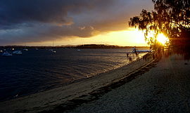
Population: approx 700 (2006) Postcode: 4184 Location: 33 km (21 mi) from Brisbane GPO LGA: Redland Shire Council State District: Electoral district of Redlands Federal Division: Division of Bowman Suburbs around Coochiemudlo Island: Thornlands Cleveland Moreton Island Mount Cotton Coochiemudlo Island Stradbroke Island Redland Bay Victoria Point Macleay Island Coochiemudlo Island is located near Brisbane, in Queensland, Australia.
Coochiemudlo Island is a small island in the southern part of Moreton Bay, Queensland. The island is approximately 1 km from Victoria Point in Redland Shire.
Coochiemudlo is an anglicised version of the local aboriginal words for "Red Rock". A natural cliff composed of iron-rich rock is exposed on the south western side of the island.
Sandy beaches wrap around the island's southern, eastern and northern sides. Mangroves cover the western foreshore of the island.
Contents
Transport
The island is serviced by a passenger ferry, operating approximately every half hour between about 5:00am and 11:00pm. A vehicular barge also operates regular services to and from the island. Due to the relatively small area, a car is not essential for getting around the island.
Wildlife
There are many types of wildlife present on the island. Although Coochiemudlo Island lacks well-known Australian wildlife such as koalas, kangaroos, possums and emus, it is well known for its birdlife including the Curlew. Unusually, the island also has a flock of peacocks which roams the island. Native wildlife include bandicoots, snakes and frogs. Other significant wildlife include pheasants, galahs, ibis, kookaburras and cockatoos.
Retail facilities
A small corner store built by former residents Douglas Sivyer and his wife Shirley provides key staple items. A cafe/restaurant and a restaurant bar are also available.
Demographic
According to the 2006 Australian Bureau of Statistics Census, Coochiemudlo had 658 people who called it home. [1] Over 43% were more than 54 years old. Of families 58.2% were couples without children. The most common responses for religious affiliation were "No Religion" at 24.2% which is well above the Australian average of 18.7%. 269 said that they were in the workforce and 60% were in full time occupations while 28% were working part time. Only 5% of the island's workforce said they were unemployed. The major areas of employment were Hospitals, Local Government Administration, Other Social Assistance Services, Residential Care Services and Building Completion Services. The median weekly household income was $616, compared with $1,027 in Australia.
Recreation
Coochiemudlo's southern beach is patrolled by the local chapter of Surf Life Saving Australia. A 'Nippers' program is also available, and caters for both on-island, and off-island children. Other facilities include:
- a BMX track
- a cricket pitch and football oval
- a Bowls/Croquet lawn
- a 9 hole golf course
- 2 tennis courts
During the years that Douglas and Shirley Sivyer provided the sole retail outlet for Coochie residents, Douglas, an accomplished musician and dancer, provided free entertainment to locals by hosting a Saturday night Bingo Evening, followed by a sing-along with Douglas providing musical accompaniment with his piano. Sadly, this entertainment ceased when Douglas developed Parkinson's Disease.
Fishing is also a popular pastime, with species such as Bream, whiting, Flathead, Flounder, Tailor, Cod, and Snapper, amongst others, to be found in the waters around the island.
Sailing
Coochie is a popular destination for sailors. As the island is surrounded on three sides by sandy beaches, there is always a sheltered beach regardless of the wind direction. Sailing craft range from sailboards, off-the-beach catamarans and dinghies to larger motor and sail yachts. A deep water anchorage and moorings are located to the south of the island near the jetty and boat ramp.
Housing styles
Housing styles on Coochiemudlo range from traditional 1950s fibro beach shacks, contemporary light weight beach houses, relocated Queenslanders (Queenslander (architecture)), and occasionally, albeit somewhat out of place, conventional suburban brick and tile.
See also
- Redland Shire
- South East Queensland
External links
- History of Coochiemudlo Island
- Moreton Bay: Queensland Places
- Coochiemudlo Island Pine Ridge Chapel columbarium
- Redland Council Open Space Plan
References
Categories:- Islands of Queensland
- Suburbs of Redland City

Wikimedia Foundation. 2010.