- Astoria, Oregon
-
Astoria, Oregon — City — Astoria and the Astoria-Megler Bridge

SealLocation in Oregon
Coordinates: 46°11′20″N 123°49′16″W / 46.18889°N 123.82111°WCoordinates: 46°11′20″N 123°49′16″W / 46.18889°N 123.82111°W Country United States State Oregon County Clatsop Founded 1811 Incorporated 1876 Government – Mayor Willis L. Van Dusen Area – Total 10.6 sq mi (27.5 km2) – Land 6.1 sq mi (15.9 km2) – Water 4.5 sq mi (11.6 km2) Elevation 23 ft (7.01 m) Population (2010[1]) – Total 9,477 – Density 1,539.8/sq mi (594.5/km2) Time zone PST (UTC-8) – Summer (DST) PDT (UTC-7) ZIP code 97103 Area code(s) 503 and 971 FIPS code 41-03150[2] GNIS feature ID 1117076[3] Website www.astoria.or.us Astoria is the county seat of Clatsop County, Oregon, United States.[4] Situated near the mouth of the Columbia River, the city was named after the American investor (and first millionaire) John Jacob Astor. His American Fur Company founded Fort Astoria at the site in 1811. Astoria was incorporated by the Oregon Legislative Assembly on October 20, 1876.[5]
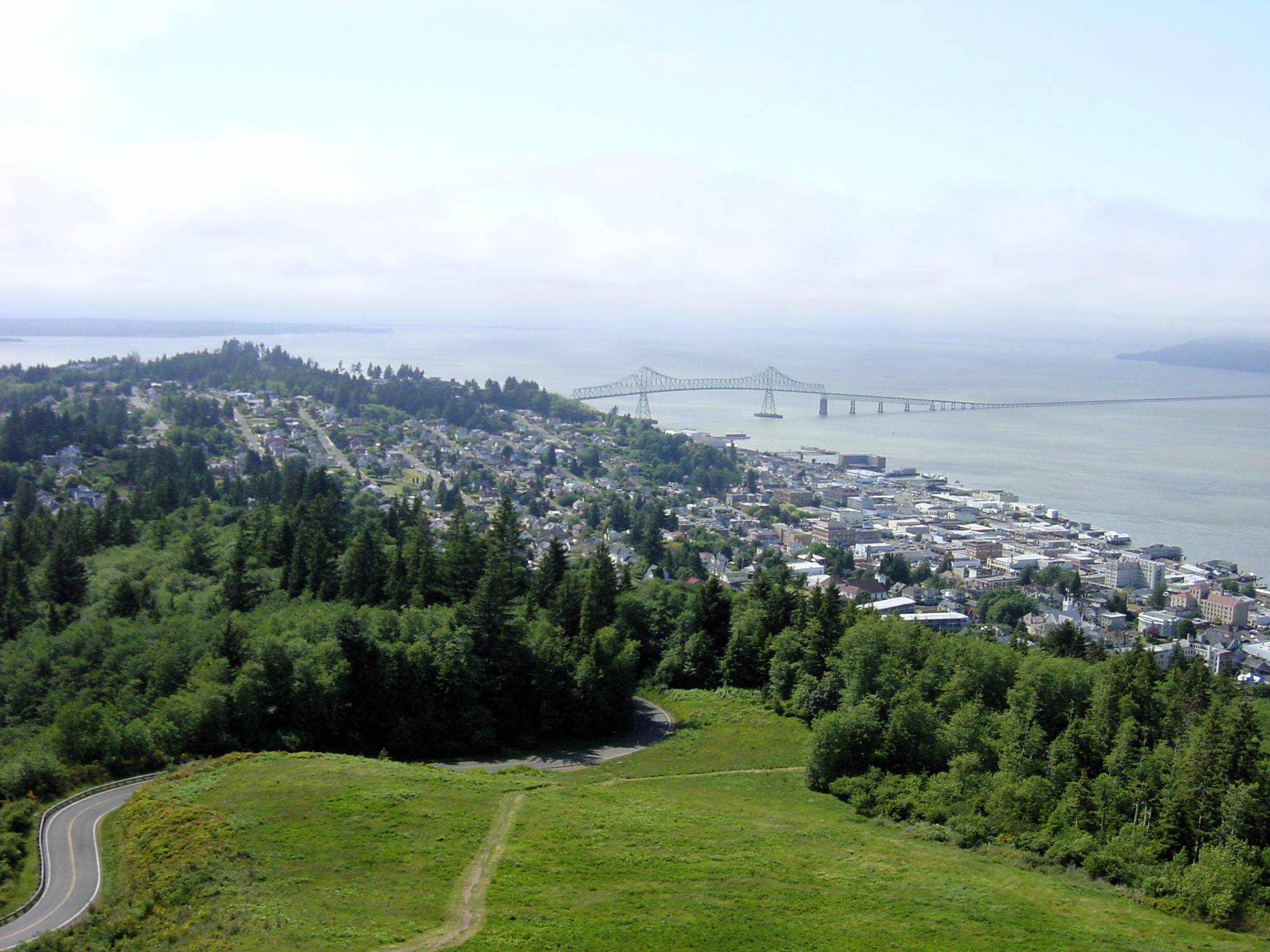
Located on the south shore of the Columbia, the city is served by the Port of Astoria with a deep-water port. Transportation includes the Astoria Regional Airport with U.S. Route 30 and U.S. Route 101 as the main highways, and the 4.2 mile Astoria – Megler Bridge connecting to neighboring Washington across the river. The population was 9,477 at the 2010 census.[1]
Contents
History
 The Methodist Mission at Astoria in 1841
 View of Astoria in 1868
 Astoria – Megler Bridge
The Lewis and Clark Expedition spent the winter of 1805–1806 at Fort Clatsop, a small log structure south and west of modern day Astoria. The expedition had hoped a ship would come by to take them back east, but instead endured a torturous winter of rain and cold, then returned east the way they came. Today the fort has been recreated and is now a national monument.
In 1810, John Jacob Astor's Pacific Fur Company sent the Astor Expedition that founded Fort Astoria as its primary fur-trading post in the Northwest, and in fact the first permanent U.S. settlement on the Pacific coast. It was an extremely important post for American exploration of the continent and was influential in establishing American claims to the land. Fort Astoria was constructed in 1811.
British explorer David Thompson was the first European to navigate the entire length of the Columbia River in 1811. Thompson reached the partially constructed Fort Astoria at the mouth of the Columbia, arriving two months after the Pacific Fur Company's ship, the Tonquin.[6]
The Pacific Fur Company failed, however, and the fort and fur trade were sold to the British in 1813. The house was restored to the U.S. in 1818, though the fur trade would remain under British control until American pioneers following the Oregon Trail began filtering into the port town in the mid-1840s. The Treaty of 1818 established joint U.S. – British occupancy of territory west of the continental divide to the Pacific Ocean. In 1846 the Oregon Treaty ended the Oregon Boundary Dispute; with Britain ceding all right to the mainland south of the 49th parallel north.
Washington Irving, a prominent American writer with a European reputation, was approached by John Jacob Astor to mythologize the three-year reign of his Pacific Fur Company. Astoria (1835), written while Irving was Astor's guest, cemented the importance of the region in the American psyche.[7] In Irving's words, the fur traders were "Sinbads of the wilderness", and their venture was a staging point for the spread of American economic power into both the continental interior and into the Pacific.
As the Oregon Territory grew and became increasingly more settled, Astoria likewise grew as a port city at the mouth of the great river that provided the easiest access to the interior. The first U.S. Post Office west of the Rocky Mountains was established in Astoria in 1847. In 1876, the community was incorporated by the state.
Astoria attracted a host of immigrants beginning in the late-19th century: Scandinavian settlers, primarily Finns, and Chinese soon became significant parts of the population. The Finns mostly lived in Uniontown, near the present-day end of the Astoria-Megler Bridge, and took fishing jobs; the Chinese tended to do cannery work, and usually lived either downtown or in bunkhouses near the canneries. In 1883, and again in 1922, downtown Astoria was devastated by fire, partly because it was mostly wood and entirely raised off the marshy ground on pilings. Even after the first fire, the same format was used, and the second time around the flames spread quickly again, as collapsing streets took out the water system. Frantic citizens resorted to dynamite, blowing up entire buildings to stop the fire from going further.
Astoria has served as a port of entry for over a century and remains the trading center for the lower Columbia basin, although it has long since been eclipsed by Portland, Oregon and Seattle, Washington as an economic hub on the coast of the Pacific Northwest. Astoria's economy centered on fishing, fish processing, and lumber. In 1945, about 30 canneries could be found along the Columbia; however, in 1974 Bumblebee Seafood moved its headquarters out of Astoria, and gradually reduced its presence until 1980 when the company closed its last Astoria cannery. The timber industry likewise declined; Astoria Plywood Mill, the city's largest employer, closed in 1989, and the Burlington Northern and Santa Fe Railway discontinued service in 1996.
From 1921 to 1966, a ferry route across the Columbia River connected Astoria with Pacific County, Washington. In 1966 the Astoria–Megler Bridge was opened; it completed U.S. Route 101 and linked Astoria with Washington on the opposite shore of the Columbia, and replaced the ferries.
Today, tourism, Astoria's growing art scene, and light manufacturing are the main economic activities of the city. It is a port of call for cruise ships since 1982, after $10 million in pier improvements to accommodate cruise ships. To avoid Mexican ports of call during the Swine Flu outbreak of 2009, many cruises were re-routed to include Astoria. The residential community The World visited Astoria in June 2009.
In addition to the replicated Fort Clatsop, a popular point of interest is the Astoria Column, a tower 125 feet (38 m) high, built atop Coxcomb Hill above the town, with an inner circular staircase allowing visitors to climb to see a panoramic view of the town, the surrounding lands, and the Columbia flowing into the Pacific. The column was built by the Astor family in 1926 to commemorate the region's early history.
Since 1998, artistically-inclined fishermen and women from Alaska and the Pacific Northwest have traveled to Astoria for the Fisher Poets Gathering, where poets and singers tell their tales to honor the fishing industry and lifestyle.
Astoria is also the western terminus of the TransAmerica Trail, a bicycle touring route created by the American Cycling Association.
Geography and climate
According to the United States Census Bureau, the city has a total area of 10.6 square miles (27 km2), of which 6.1 square miles (15.8 km2) is land and 4.5 square miles (11.7 km2) (42.18%) is water.
Climate
Astoria lies within the Marine west coast climate zone (Köppen Cfb), with very mild temperatures year-round, some of the most consistent in the continental United States; winters are mild for Astoria's latitude, generally above freezing, even at night, and wet. Summers are cool, although short heat waves can occur. Rainfall is most abundant in late fall and winter, and lightest in mid-late summer. Snowfall is relatively rare but can accumulate in small amounts in winter.
Annually, there is an average of only 0.5 days with maximum temperatures of 90 °F (32 °C) or higher. There are an average of 34.3 days with minimum temperatures at or below the freezing mark. The record high temperature was 101 °F (38 °C) on July 1, 1942. The record low temperature was 6 °F (−14 °C) on December 8, 1972.
There are an average of 194 days with measurable precipitation. The wettest year was 1950 with 113.34 inches (2,879 mm) and the driest year was 1985 with 41.58 inches (1,056 mm). The most rainfall in one month was 36.07 inches (916 mm) in December 1933. The most rainfall in 24 hours was 5.56 inches (141 mm) on November 25, 1998. The most snowfall in one month was 26.9 inches (680 mm) in January 1950.[8]
Climate data for Astoria, Oregon (1971–2000) Month Jan Feb Mar Apr May Jun Jul Aug Sep Oct Nov Dec Year Average high °F (°C) 48.1
(8.9)50.8
(10.4)53.3
(11.8)56.1
(13.4)60.0
(15.6)63.6
(17.6)67.2
(19.6)68.3
(20.2)67.5
(19.7)61.0
(16.1)53.1
(11.7)48.4
(9.1)58.1 Average low °F (°C) 36.7
(2.6)37.6
(3.1)38.6
(3.7)40.8
(4.9)45.4
(7.4)49.8
(9.9)52.9
(11.6)53.2
(11.8)49.5
(9.7)44.1
(6.7)40.1
(4.5)37.1
(2.8)43.8 Precipitation inches (mm) 9.62
(244.3)7.87
(199.9)7.37
(187.2)4.93
(125.2)3.28
(83.3)2.57
(65.3)1.16
(29.5)1.21
(30.7)2.61
(66.3)5.61
(142.5)10.50
(266.7)10.40
(264.2)67.13
(1,705.1)Snowfall inches (cm) 1.2
(3).4
(1).2
(0.5).1
(0.3)0
(0)0
(0)0
(0)0
(0)0
(0)0
(0).3
(0.8)1.0
(2.5)3.2
(8.1)Avg. precipitation days (≥ 0.01 in) 20.8 18.8 20.7 18.2 16.1 13.1 8.3 7.2 9.4 14.8 20.9 21.2 189.5 Avg. snowy days (≥ 0.1 in) .8 .6 .2 .2 0 0 0 0 0 0 .3 .6 2.7 Source: NOAA [9] Demographics
Historical populations Census Pop. %± 1860 252 — 1870 639 153.6% 1880 2,803 338.7% 1890 6,184 120.6% 1900 8,351 35.0% 1910 9,599 14.9% 1920 14,027 46.1% 1930 10,349 −26.2% 1940 10,389 0.4% 1950 12,331 18.7% 1960 11,239 −8.9% 1970 10,244 −8.9% 1980 9,998 −2.4% 1990 10,069 0.7% 2000 9,813 −2.5% 2010 9,477 −3.4% Sources:[1][10][11] As of the census[2] of 2000, there were 9,813 people, 4,235 households, and 2,469 families residing in the city. The population density was 1,597.6 people per square mile (617.1 per km²). There were 4,858 housing units at an average density of 790.9 per square mile (305.5 per km²). The racial makeup of the city was:
- 91.08% White
- 0.52% Black or African American
- 1.14% Native American
- 1.94% Asian
- 0.19% Pacific Islander
- 2.67% from other races
- 2.46% from two or more races
5.98% of the population were Hispanic American or Latino of any race.
14.2% were of German, 11.4% Irish, 10.2% English, 8.3% United States or American, 6.1% Finnish, 5.6% Norwegian, and 5.4% Scottish ancestry according to Census 2000.
There were 4,235 households out of which 28.8% had children under the age of 18 living with them, 43.5% were married couples living together, 11.2% had a female householder with no husband present, and 41.7% were non-families. 35.4% of all households were made up of individuals and 13.6% had someone living alone who was 65 years of age or older. The average household size was 2.26 and the average family size was 2.93.
In the city the population was spread out with:
- 24.0% under the age of 18
- 9.1% from 18 to 24
- 26.4% from 25 to 44
- 24.5% from 45 to 64
- 15.9% 65 years of age or older.
The median age was 38 years. For every 100 females there were 92.3 males. For every 100 females age 18 and over, there were 89.9 males.
The median income for a household in the city was $33,011, and the median income for a family was $41,446. Males had a median income of $29,813 versus $22,121 for females. The per capita income for the city was $18,759. About 11.6% of families and 15.9% of the population were below the poverty line, including 22.0% of those under age 18 and 9.6% of those age 65 or over.
Education
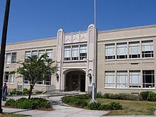 John Jacob Astor Elementary
The Astoria School District has four primary and secondary schools, including Astoria High School. Clatsop Community College is the city's two-year college.
Media
The Daily Astorian is a newspaper serving Astoria, the local NPR station is KMUN 91.9, and KAST 1370 is a local news-talk radio station.
Astoria in popular culture
See also: List of fiction set in OregonShanghaied In Astoria is a musical about Astoria's history, that has been performed in Astoria every year since 1984.
Astoria was the setting of the 1985 movie The Goonies, which was filmed on location. Other movies filmed in Astoria include Short Circuit, The Black Stallion, Kindergarten Cop, Free Willy, Free Willy 2: The Adventure Home, Teenage Mutant Ninja Turtles III, Benji the Hunted, The Ring Two, Into the Wild, The Guardian and Cthulhu.
The early 1960s television series Route 66 filmed the episode entitled "One Tiger to a Hill"[12] in Astoria; it was broadcast on September 21, 1962.
Museums and other points of interest
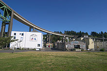 Suomi Hall, the meeting hall of Finnish and Scandinavian immigrants, under the Astoria-Megler Bridge
- Columbia River Maritime Museum
- Peter Iredale shipwreck
- Astoria Regional Airport
- Clatsop Spit
- CGAS Astoria
Sister cities
Astoria has one sister city,[13] as designated by Sister Cities International:
 Walldorf, Germany, which is the birthplace of Astoria's namesake, John Jacob Astor, who was born in Walldorf near Heidelberg on July 17, 1763. The sistercityship was founded on Astor's 200. birthday on July 17, 1963 in Walldorf by Walldorf's mayor Wilhelm Willinger and Astoria's mayor Harry Steinbock.[14]
Notable people
- Brian Bruney, Major League Baseball relief pitcher
- Clark Gable, actor, began his career at the Astoria Theatre in 1922.[15]
- Michael Hurley, American Singer/Songwriter
- Ranald MacDonald, first man to teach the English language in Japan
- Holly Madison, one of Hugh Hefner's ex-girlfriends,[16] born in Astoria but left before 2nd birthday
- Donald Malarkey, World War II U.S. Army soldier of the 101st Airborne Division was portrayed in the TV series Band of Brothers.
- Joshua Marquis, District Attorney
- Santeri Nuorteva, Finnish socialist politician and journalist, who edited Toveri ("The Comrade") in Astoria in 1912–1913.[17]
- Maila Nurmi, aka 1950s TV horror hostess Vampira and co-star of Ed Wood's Plan 9 From Outer Space attended Astoria High School in the late 1930s.[18]
Further reading
- Ebeling, Herbert C.: Johann Jakob Astor. Walldorf, Astor-Stiftung, 1998. ISBN 3-00-003749-7.
- Leedom, Karen L.: Astoria: An Oregon History. Rivertide Publishing, 2008. ISBN-978-0-9826252-1-7.
- MacGibbon, Elma (1904). Leaves of knowledge. Shaw & Borden Co. http://www.secstate.wa.gov/history/publications%5Fdetail.aspx?p=63. Elma MacGibbons reminiscences about her travels in the United States starting in 1898, which were mainly in Oregon and Washington. Includes chapter "Astoria and the Columbia River."
See also
References
- ^ a b c "2010 Census profiles: Oregon cities alphabetically A-C" (PDF). Portland State University Population Research Center. http://www.pdx.edu/sites/www.pdx.edu.prc/files/media_assets/2010_PL94_cities_A-C_updated.pdf. Retrieved 12 June 2011.
- ^ a b "American FactFinder". United States Census Bureau. http://factfinder.census.gov. Retrieved 2008-01-31.
- ^ "US Board on Geographic Names". United States Geological Survey. 2007-10-25. http://geonames.usgs.gov. Retrieved 2008-01-31.
- ^ "Find a County". National Association of Counties. http://www.naco.org/Counties/Pages/FindACounty.aspx. Retrieved 2011-06-07.
- ^ Leeds, W. H. (1899). "Special Laws". The State of Oregon General and Special Laws and Joint Resolutions and Memorials Enacted and Adopted by the Twentieth Regular Session of the Legislative Assembly (Salem, Oregon: State Printer): 747. http://books.google.com/?id=gsCwAAAAIAAJ&dq=%22ocean%20grove%22%20seaside%20oregon&pg=PA747.
- ^ Meinig, D.W. (1995) [1968]. The Great Columbia Plain (Weyerhaeuser Environmental Classic ed.). University of Washington Press. pp. 37–38, 50. ISBN 0-295-97485-0.
- ^ In his Introduction to the rambling work, Irving reports that Astor explicitly "expressed a regret that the true nature and extent of his enterprizeand its national character and importance had never been understood."
- ^ http://www.wrcc.dri.edu/cgi-bin/cliMAIN.pl?or0324; http://www.wrcc.dri.edu/cgi-bin/cliMAIN.pl?or0328
- ^ "Climatography of the United States No. 20 (1971–2000)" (PDF). National Oceanic and Atmospheric Administration. 2004. http://cdo.ncdc.noaa.gov/climatenormals/clim20/va/448906.pdf. Retrieved 2011-06-16.
- ^ Moffat, Riley. Population History of Western U.S. Cities & Towns, 1850–1990. Lanham: Scarecrow, 1996, 206.
- ^ "Subcounty population estimates: Oregon 2000–2007" (CSV). United States Census Bureau, Population Division. March 18, 2009. http://www.census.gov/popest/cities/files/SUB-EST2007-41.csv. Retrieved May 3, 2009.
- ^ "Route 66" One Tiger to a Hill (1962)
- ^ Sister Cities International
- ^ Ebeling, Herbert C. (1998). Johann Jakob Astor, Walldorf Astor-Stiftung. pp. 351–354. ISBN 3000037497.
- ^ "Astoria Theatre Sign". http://www.flickr.com/photos/antiuser/426380299/in/set-72157600008412065/. Retrieved June 9, 2009.
- ^ TMZ.com (October 7, 2008). "Holly to Hugh: Hef Off". http://www.tmz.com/2008/10/07/holly-to-hugh-hef-off/. Retrieved October 7, 2008.
- ^ Paul George Hummasti, Finnish Radicals in Astoria, Oregon, 1904–1940: A Study in Immigrant Socialism. New York: Arno Press, 1979; pg. 44.
- ^ "Vampira: The haunting of Astoria High School". The Daily Astorian. October 31, 2008. http://www.dailyastorian.com/Main.asp?SectionID=2&ArticleID=55578. Retrieved February 13, 2009.
External links
 Media related to Astoria, Oregon at Wikimedia Commons
 "Astoria". The American Cyclopædia. 1879.
- Astoria-Warrenton Chamber of Commerce
- Oregon Blue Book listing for Astoria
- Social and Economic History of Astoria
Municipalities and communities of Clatsop County, Oregon County seat: AstoriaCities Astoria | Cannon Beach | Gearhart | Seaside | Warrenton

Unincorporated
communitiesArch Cape | Brownsmead | Elsie | Hamlet | Jeffers Garden | Jewell | Jewell Junction | Knappa | Lukarilla | Melville | Miles Crossing | Navy Heights | Necanicum | Olney | Sunset Beach | Surf Pines | Svensen | Tolovana Park | Wauna | Westport
Categories:- Astoria, Oregon
- Cities in Oregon
- Populated places on the Columbia River
- County seats in Oregon
- Populated places in Clatsop County, Oregon
- Astor family
- Populated places established in 1810
- Micropolitan areas of Oregon
- Port cities in Oregon


Wikimedia Foundation. 2010.