- List of National Historic Landmarks in Wyoming
-
The list of National Historic Landmarks in Wyoming contains the landmarks designated by the U.S. Federal Government for the U.S. state of Wyoming. There are 24 National Historic Landmarks (NHLs) in Wyoming. The first designated were two on 19 December 1960; the latest was on 20 September 2006.
Landmark name[1] Image Date declared[1] Locality[1][2] County[1] Description[2] 1 Expedition Island 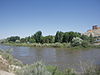
November 24, 1968 Green River Sweet-
waterExpedition Island is a park in Green River, Wyoming that marks the area where Major John Wesley Powell started an expedition down the Green River and Colorado River in 1871. 2 Fort D.A. Russell 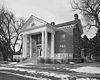
May 15, 1975 Cheyenne Laramie In 1867, the fort was established to protect workers for the Union Pacific Railroad. In 1871, it was base to the Pawnee scout battalion.[3] 3 Fort Phil Kearny and Associated Sites 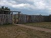
December 19, 1960 Story Johnson Fort Phil Kearny was an outpost of the United States Army that existed in the late 1860s in present-day northeastern Wyoming along the Bozeman Trail.[4] 4 Fort Yellowstone 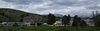
July 31, 2003 Yellowstone National Park Park Fort Yellowstone is a former United States Army base created in 1888 to guard the park. It became administrative headquarters of Yellowstone National Park.[5] 5 Heart Mountain Relocation Center 
September 20, 2006 Ralston Park An internment camp for Japanese-Americans during World War II 6 Horner Site 
January 20, 1961 Cody Park Non-public archaeological site yielding evidence of a flint tool culture, with occupation dating back to 5000 BC.[6] 7 Independence Rock 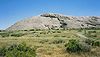
January 20, 1961 Casper Natrona Independence Rock is a large granite rock, approximately 130 ft (40 m) high, which served as a landmark on the Oregon Trail and California Trail in southwestern Natrona County.[7] 8 Jackson Lake Lodge 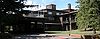
July 31, 2003 Grand Teton National Park Teton Designed by architect Gilbert Stanley Underwood and completed in 1955, the lodge built in International style represents a break from the traditional rustic style of architecture used by the National Park Service. 9 Lake Guernsey State Park 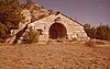
September 25, 1997 Guernsey Platte Model Civilian Conservation Corps-built state park buildings and structures 10 Medicine Wheel 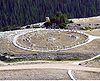
August 29, 1970 Lovell Big Horn A native American medicine wheel, used for healing and religious purposes 11 Murie Ranch Historic District 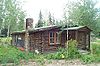
February 17, 2006 Grand Teton National Park[8] Teton A group of several cabins in Grand Teton National Park that were owned by naturalist Olaus Murie, his wife Margaret Murie and scientist Adolph Murie and his wife Louise in the 1940s. 12 Norris, Madison, and Fishing Bridge Museums 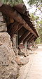
May 28, 1987 Yellowstone National Park
44°43′27″N 110°42′21″W / 44.72424°N 110.70578°WTeton and Park Three "trailside museums" in National Park Service Rustic style within Yellowstone National Park 13 Obsidian Cliff 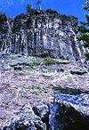
June 19, 1996 Yellowstone National Park Park An exposure of obsidian (volcanic glass). It was a notable source of lithic materials for prehistoric peoples. 14 Old Faithful Inn 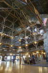
May 28, 1987 Yellowstone National Park
44°27′28″N 110°49′49″W / 44.45784°N 110.83031°WTeton National Park Service architecture 15 Oregon Trail Ruts 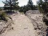
May 23, 1966 Guernsey Platte One half mile long section of Oregon Trail, worn 2–6 feet into sandstone ridge 16 J. C. Penney Historic District 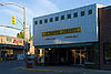
June 2, 1978 Kemmerer Lincoln Buildings associated with James Cash Penney's founding of J. C. Penney department store chain here. 17 Sheridan Inn 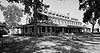
January 29, 1964 Sheridan
44°48′25″N 106°57′12″W / 44.80683°N 106.95333°WSheridan Inn operated by Buffalo Bill Cody 18 South Pass 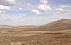
January 20, 1961 South Pass City Fremont This was the easiest crossing point of the Continental Divide during the 19th century, serving American pioneers, fur traders, and miners. The access it offered to the Pacific Northwest greatly strengthened the U.S. claim to that region. 19 Tom Sun Ranch 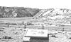
December 19, 1960 Casper Carbon and Natrona Tom Sun Ranch was a typical medium-sized ranching operation of the open range period in the 1870s-80s. Tom Sun was a French-Canadian cattleman and frontiersman. 20 Swan Land and Cattle Company Headquarters 
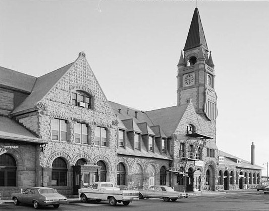
July 19, 1964 Chugwater Platte The surviving buildings include the ranchhouse, barn, and commissary, for this company organized in Scotland in 1883.[9] 21 Union Pacific Railroad Depot 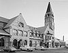
February 15, 2006 Cheyenne Laramie Railroad depot and related buildings. 22 Upper Green River Rendezvous Site 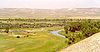
November 5, 1961 Daniel Sublette Rendezvous site on the Green River 23 Wapiti Ranger Station 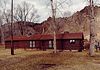
May 23, 1963 Wapiti
44°27′50″N 109°36′58″W / 44.46388°N 109.61613°WPark First U.S. Forest Service ranger station 24 Wyoming State Capitol 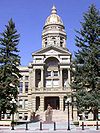
May 4, 1987 Cheyenne
41°08′23″N 104°49′12″W / 41.13983°N 104.81992°WLaramie Current state capitol building See also
- Historic preservation
- List of National Historic Landmarks by state
- List of Registered Historic Places in Wyoming
References
- ^ a b c d National Park Service (June 2011). "National Historic Landmarks Survey: List of National Historic Landmarks by State" (PDF). http://www.cr.nps.gov/nhl/designations/Lists/LIST11.pdf. Retrieved 2011-07-04.
- ^ a b National Park Service. "National Historic Landmark Program: NHL Database". http://tps.cr.nps.gov/nhl/default.cfm. Retrieved 2007-09-22.
- ^ NPS webpage, March 2009: NPS-gov-842.
- ^ NPS webpage, March 2009: NPS-gov-565.
- ^ NPS webpage, March 2009: NPS-gov-32**.
- ^ NPS webpage, March 2009: NPS-gov-567.
- ^ NPS webpage, March 2009: NPS-gov-566.
- ^ National Park Service (2007). "Murie Ranch - National Park Week: National Register of Historic Places Celebrates National Park". http://www.nps.gov/history/nr/feature/ParkWeek/2007/murieranch.htm. Retrieved 2007-12-16.
- ^ NPS webpage, March 2009: NPS-gov-569.
External links
- National Historic Landmark Program at the National Park Service
- Lists of National Historic Landmarks
National Historic Landmarks by state State Alabama • Alaska • Arizona • Arkansas • California • Colorado • Connecticut • Delaware • Florida • Georgia • Hawaii • Idaho • Illinois • Indiana • Iowa • Kansas • Kentucky • Louisiana • Maine • Maryland • Massachusetts (Boston) • Michigan • Minnesota • Mississippi • Missouri • Montana • Nebraska • Nevada • New Hampshire • New Jersey • New Mexico • New York (New York City) • North Carolina • North Dakota • Ohio • Oklahoma • Oregon • Pennsylvania (Philadelphia) • Rhode Island • South Carolina • South Dakota • Tennessee • Texas • Utah • Vermont • Virginia • Washington • West Virginia • Wisconsin • WyomingFederal district Other  State of Wyoming
Topics - Governors
- Delegations
- Geography
- Government
- History
- People
- Visitor Attractions
- State Symbols
- Radio Stations
Society - Crime
- Demographics
- Economy
- Education
- Politics
Regions Cities Counties U.S. National Register of Historic Places Topics Lists by states Alabama • Alaska • Arizona • Arkansas • California • Colorado • Connecticut • Delaware • Florida • Georgia • Hawaii • Idaho • Illinois • Indiana • Iowa • Kansas • Kentucky • Louisiana • Maine • Maryland • Massachusetts • Michigan • Minnesota • Mississippi • Missouri • Montana • Nebraska • Nevada • New Hampshire • New Jersey • New Mexico • New York • North Carolina • North Dakota • Ohio • Oklahoma • Oregon • Pennsylvania • Rhode Island • South Carolina • South Dakota • Tennessee • Texas • Utah • Vermont • Virginia • Washington • West Virginia • Wisconsin • WyomingLists by territories Lists by associated states Other Categories:- Lists of National Historic Landmarks by state
- National Historic Landmarks in Wyoming
- Wyoming-related lists


Wikimedia Foundation. 2010.