- Geography of Afghanistan
-
Afghanistan 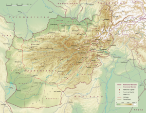
Continent Asia Subregion Central Asia Geographic coordinates 33°00′N 65°00′E / 33°N 65°E Area
- Total
- WaterRanked 41st
647,500 km2 (250,000 sq mi)
0 km2 (landlocked)Coastline landlocked Land boundaries 5,529 km (3,436 mi) Countries bordered Pakistan 2,430 km (1,510 mi),
Tajikistan 1,206 km (749 mi),
Iran 936 km (582 mi),
Turkmenistan 744 km (462 mi),
Uzbekistan 137 km (85 mi),
China 76 km (47 mi)Highest point Noshaq, 7,492 m (24,580 ft) Lowest point Amu Darya, 258 m (846 ft) Longest river Helmand River Largest inland body of water Land Use
- Arable land
- Permanent crops
- Other(2005 estimates)
12.13%
0.21%
87.66%Irrigated Land 27,200 km2 (10,500 sq mi) Climate: Arid to semiarid Natural resources natural gas, petroleum, coal, copper, uranium, gold, silver, chromite, talc, barites, sulfur, lead, zinc, iron ore, salt, precious and semiprecious stone[1][2][3][4][5] Natural hazards earthquakes, flooding, avalanches Environmental issues limited fresh water, overgrazing, deforestation, desertification, air and water pollution Afghanistan is a landlocked nation located in Central Asia. Strategically located at the crossroads of major north-south and east-west trade routes, it has attracted a succession of invaders including Alexander the Great, in the fourth century B.C. Currently, the United States continues the global war on terrorism there.
Kabul, is the capital and largest city of Afghanistan, located in the Kabul Province. According to the 2008 official estimates, the population of Kabul metropolitan area is 2.8 million people.
The Hindu Kush mountains, running northeast to southwest across the country, divide it into three major regions: 1) the Central Highlands, which form part of the Himalayas and account for roughly two thirds of the country’s area; 2) the Southwestern Plateau, which accounts for one-fourth of the land; and 3) the smaller Northern Plains area, which contains the country’s most fertile soil.
Land elevations generally slope from northeast to southwest, following the general shape of the Hindu Kush massif, from its highest point in the Pamir Mountains near the Chinese border to the lower elevations near the border with Iran. To the north, west, and southwest there are no mountain barriers to neighboring countries. The northern plains pass almost imperceptibly into the plains of Turkmenistan. In the west and southwest, the plateaus and deserts merge into those of Iran. Afghanistan is located on the Eurasian Tectonic Plate. The Wakhan Corridor and the rest of northeastern Afghanistan, including Kabul, are situated in a geologically active area. Over a dozen earthquakes occurred there during the twentieth century.
The greater part of the northern border and a small section of the border with Pakistan are marked by rivers; the remaining boundary lines are political rather than natural. The northern frontier extends approximately 1,689 km (1,049 mi) southwestward, from the Pamir Mountains in the northeast to a region of hills and deserts in the west, at the border with Iran. The border with Iran runs generally southward from the Hari River across swamp and desert regions before reaching the northwestern tip of Pakistan. Its southern section crosses the Helmand River.Afghanistan is bounded by six different countries. Its longest border is the poorly marked Durand Line, accounting for its entire southern and eastern boundary with Pakistan. The shortest one, bordering China’s Xinjiang province, is a mere 76 km at the end of the Wakhan Corridor (the Afghan Panhandle), a narrow sliver of land 241 km (150 mi) long that extends eastward between Tajikistan and Pakistan. At its narrowest point it is only 11 km (7 mi) wide.
The border with Pakistan runs eastward from Iran through the Chagai Hills and the southern end of the Registan Desert, then northward through mountainous country. It then follows an irregular northeasterly course before reaching the Durand Line, established in 1893. This line continues on through mountainous regions to the Khyber Pass area. Beyond this point it rises to the crest of the Hindu Kush, which it follows eastward to the Pamir Mountains. The Durand Line divides the Pashtun tribes of the region between Afghanistan and Pakistan. Its creation has caused much dissatisfaction among Afghans and has given rise to political tensions between the two countries.
Contents
Mountain systems

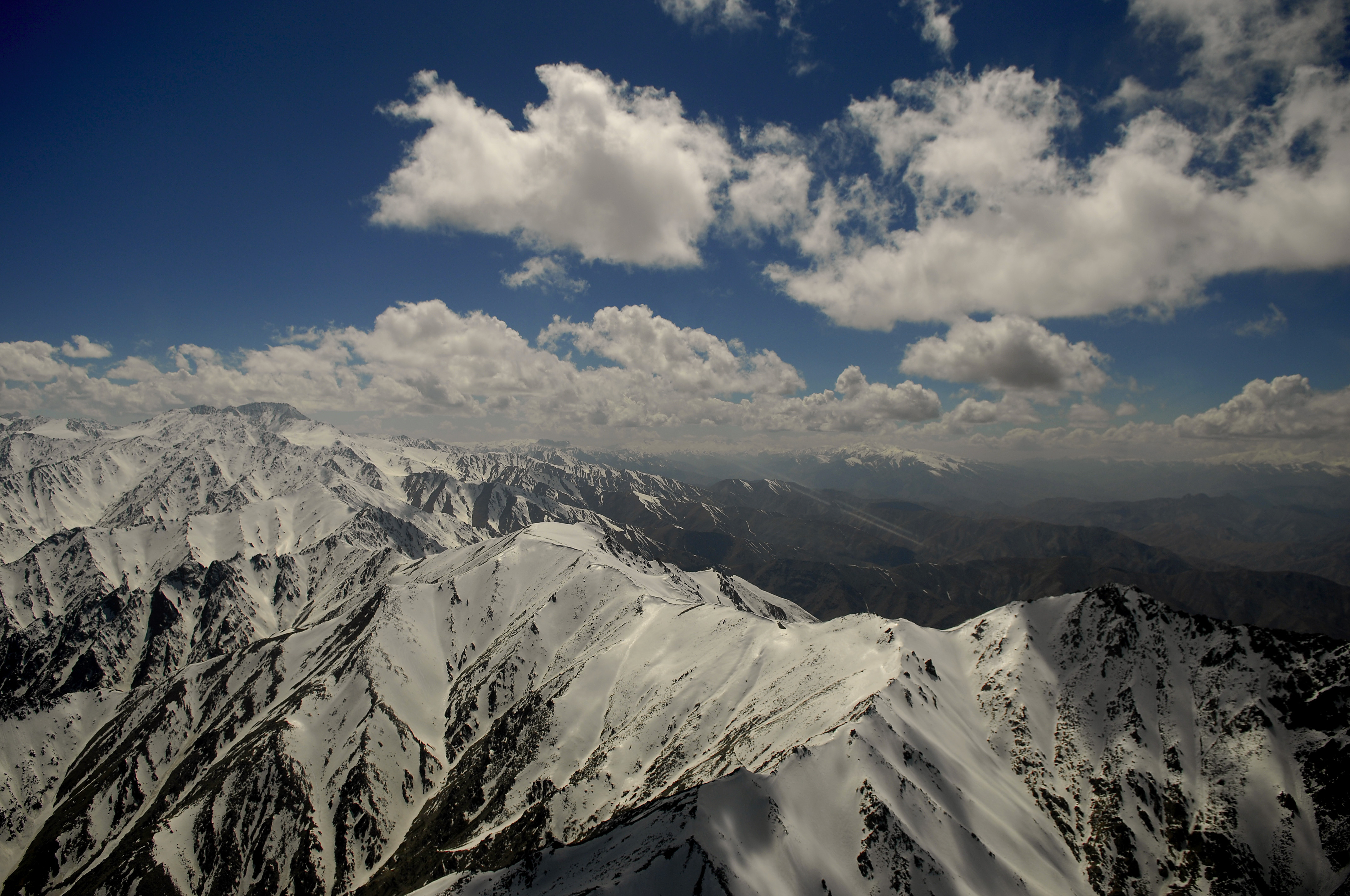
The Hindu Kush reaches a height of 7,492 m (24,580 ft) at Noshaq, Afghanistan's highest peak. Of the ranges extending southwestward from the Hindu Kush, the Foladi peak (Shah Fuladi) of the Baba mountain range (Koh-i-Baba) reaches the greatest height: 5,142 m (16,870 ft). The Safed Koh range, which includes the Tora Bora area, dominates the border area southeast of Kabul.
Important passes include the Unai Pass across the Safed Koh, the Kushan and Salang Passes through the Hindu Kush, and the Khyber Pass that connects Afghanistan with Pakistan. The summit of the Khyber Pass at 1,070 m (3,510 ft) at Landi Kotal, Pakistan is 5 km (3 mi) east of the border town of Torkham. Other key passages through the mountainous Pakistan border include two from Paktika Province into Pakistan's Waziristan region: one at Angoor Ada, a village that straddles both sides of the border east of Shkin, and, further south, the Gumal River crossing, plus the Charkai River passage south of Khowst, Afghanistan, at Pakistan's Ghulam Khan village into North Waziristan. The busy Pakistan border crossing at Wesh, just northwest of Chaman, Pakistan, connecting Kandahar and Spin Boldak, Afghanistan, to Quetta, Pakistan, is in a flat, dry area, though this route involves Pakistan's Khojak Pass at 2,707 m (8,881 ft) just 14 km (9 mi) from the border.
 Snow-covered mountains in the Paktia Province.
The Wakhan Corridor in the northeast lies between the Hindu Kush and the Pamir Mountains, which leads to the Wakhjir Pass into Xinjiang in China. Taking the highlands of the country as a whole, there is no great difference between the mean temperature of Afghanistan and that of the lower Himalaya. Each may be placed at a point between . However, the remarkable feature of Afghan climate is its extreme range of temperature within limited periods. The smallest daily range in the north is when the weather is cold; the greatest is when it is hot. For seven months of the year (from May to November) this range exceeds 17 °C (31 °F) daily. Waves of intense cold occur, lasting for several days, and one may have to endure a cold of −24 °C (−11 °F), rising to a maximum of −8 °C (18 °F). On the other hand, the summer temperature is exceedingly high, especially in the Oxus regions, where a shade maximum of 45–50 °C (113–122 °F) is not uncommon. At Kabul, and over all the northern part of the country to the descent at Gandamak, winter is rigorous, but especially so on the high Arachosian plateau. In Kabul the snow lies for two or three months; the people seldom leave their houses, and sleep close to stoves. At Ghazni the snow has been known to lie long beyond the vernal equinox; the thermometer sinks as low as −25 °C (−13 °F), and tradition relates the destruction of the entire population of Ghazni by snowstorms more than once.
 Topography
The summer heat is great in the Sistan Basin, Jalalabad and Turkestan, especially Sistan. All over Kandahar province the summer heat is intense, and the simoom is not unknown. The hot season throughout this part of the country is rendered more trying by frequent dust storms and fiery winds; whilst the bare rocky ridges that traverse the country, absorbing heat by day and radiating it by night, render the summer nights most oppressive. At Kabul the summer sun has great power, though the heat is tempered occasionally by cool breezes from the Hindu Kush, and the nights are usually cool. At Kandahar snow seldom falls on the plains or lower hills; when it does, it melts at once.
 Landscape in Afghanistan
Although Herat is approximately 240 m (787 ft) lower than Kandahar, the summer climate there is more temperate, and the climate throughout the year is far from disagreeable. From May to September, the wind blows from the northwest with great force, and this extends across the country to Kandahar. The winter is tolerably mild; snow melts as it falls, and even on the mountains does not lie long. Three years out of four at Herat it does not freeze hard enough for the people to store ice; yet it was not very far from Herat, and could not have been at a greatly higher level (at Rafir Kala, near Kassan) that, in 1750, Ahmad Shah's army, retreating from Persia, is said to have lost 18,000 men from cold in a single night. In the northern Herat districts, too, records of the coldest month (February) show the mean minimum as −8 °C (18 °F) and the maximum as 3 °C (37 °F). The eastern reaches of the Hari River, including the rapids, are frozen hard in the winter, and people travel on it as on a road.
The summer rains that accompany the southwest monsoon in India, beating along the southern slopes of the Himalaya, travel up the Kabul valley as far as Laghman, though they are more clearly felt in Bajour and Panjkora, under the high spurs of the Hindu Kush, and in the eastern branches of Safed Koh. Rain also falls at this season at the head of Kurram valley. South of this the Suliman mountains may be taken as the western limit of the monsoon's action. It is quite unfelt in the rest of Afghanistan, in which, as in all the west of Asia, the winter rains are the most considerable. The spring rain, though less copious, is more important to agriculture than the winter rain, unless where the latter falls in the form of snow. In the absence of monsoon influences there are steadier weather indications than in India. The north-west blizzards which occur in winter and spring are the most noticeable feature, and their influence is clearly felt on the Indian frontier. The cold is then intense and the force of the wind cyclonic. Speaking generally, the Afghanistan climate is a dry one. The sun shines with splendor for three-fourths of the year, and the nights are even more clear than the days. Marked characteristics are the great differences of summer and winter temperature and of day and night temperature, as well as the extent to which change of climate can be attained by slight change of place. The highest temperature ever recorded under standard conditions was 49.9 °C (121.8 °F) at Farah in August 2009 and the lowest was −52.2 °C (−62.0 °F) at Shahrak in January 1964.[citation needed] The emperor Babur observed:
“ Within a day's ride from Kabul it is possible to reach a place where snow never falls. But within two hours one can go where the snow never melts—except in the rare summer so severe that all snow disappears. Both tropical and cold-weather fruits are abundant in Kabul's dependencies, and they are nearby.[6] ” Rivers and lakes
See also: List of rivers of Afghanistan and List of dams and reservoirs in Afghanistan Band-e Amir in central Afghanistan
Afghanistan does not face any water shortage because it receives huge amount of snow during winter and once that melts the water runs into rivers, lakes, and streams, but most of its national water flows to neighboring states. It loses about two-thirds of its water from snow and rain annually, which flows mainly to Pakistan, Iran and Tajikistan. The country needs several billion dollars to rehabilitate its irrigation systems so that the water is properly used.[7] The Afghan government is asking for a $12 billion investment from the international community to construct a number of dams for the production of electricity and to help the irrigation of the country.[8] The nation's drainage system is essentially landlocked. Most of the rivers and streams end in shallow desert lakes or oases inside or outside the country’s boundaries. Nearly half of the country's total area is drained by watercourses south of the Hindu Kush–Safid ridge line, and half of this area is drained by the Helmand and its tributaries alone. The Amu Darya on the northern border, the country's other major river, has the next largest drainage area.
 Scenic view in western Afghanistan
The 2,661 km (1,653 mi) long Amu Darya originates in the glaciers of the Pamir Mountains in the northeast. Some 965 km of its upper course constitutes Afghanistan's border with Turkmenistan, Uzbekistan and Tajikistan. Flowing in rapid torrents in its upper course, the Amu Darya becomes calmer below the mouth of the Kokcha, 96 km (60 mi) west of Fayzabad. The Kunduz River is another major tributary. During its flood period the upper course of the Amu Darya, swollen by snow and melting ice, carries along much gravel and large boulders.
The Helmand River is the principal river in the southwest, bisecting the entire region. Starting some 80 km (50 mi) west of Kabul in the Baba mountain range, the Helmand is approximately 1,400 km (870 mi) long, making it the longest river situated entirely within Afghanistan. With its many tributaries, the most important of which is the Arghandab River, it drains more than 298 km2 (115 sq mi).
The Kabul River, 515 km (320 mi) long, is a vital source of water in the Baba Mountains and for Kabul itself, which it flows through. The Kabul and its tributaries are among the few in Afghanistan that eventually reach the sea, as it flows east into the Indus River in Pakistan.
In the west the sandy deserts along most of the Iranian frontier have no watercourses. However, in the northwest, the Hari and Morghab Rivers flow into Turkmenistan's Karakum Desert.
Vegetation
 Northwestern Afghanistan
 Eastern Afghanistan
The characteristic distribution of vegetation on the mountains of Afghanistan is worthy of attention. The great mass of it is confined to the main ranges and their immediate off-shoots, whilst on the more distant and terminal prolongations it is almost entirely absent; in fact, these are naked rock and stone.
Take, for example, the Safed Koh. On the alpine range itself and its immediate branches, at a height of 1,800–3,000 m (5,900–9,800 ft) there is abundant growth of large forest trees, among which conifers are the most noble and prominent, such as Cedrus deodara, Abies excelsa, Pinus longifolia, Pinus pinaster, Stone pine (the edible pine, although this species is probably introduced, since it is original to Spain and Portugal) and the larch. There is also the yew, the hazel, juniper, walnut, wild peach and almond. Growing under the shade of these are several varieties of rose, honeysuckle, currant, gooseberry, hawthorn, rhododendron and a luxuriant herbage, among which the ranunculus family is important for frequency and number of genera. The lemon and wild vine are also here met with, but are more common on the northern mountains. The walnut and oak (evergreen, holly-leaved and kermes) descend to the secondary heights, where they become mixed with alder, ash, khinjak, Arbor-vitae, juniper, with species of Astragalus, &c. Here also are Indigoferae rind dwarf laburnum.
Down to 1,000 m (3,300 ft) there are wild olive, species of rock-rose, wild privet, acacias and mimosas, barberry and Zizyphus; and in the eastern ramifications of the chain, Chamaerops humilis (which is applied to a variety of useful purposes, and which it is also introduced since it is original to Western Mediterranean), Bignonia or trumpet flower, sissu, Salvadora persica, verbena, acanthus, varieties of Gesnerae.
The lowest terminal ridges, especially towards the west, are, as it has been said, naked in aspect. Their scanty vegetation is almost wholly herbal; shrubs are only occasional; trees almost non-existent. Labiate, composite and umbelliferous plants are most common. Ferns and mosses are almost confined to the higher ranges.
In the low brushwood scattered over portions of the dreary plains of the Kandahar tablelands, it is possible to find leguminous thorny plants of the papilionaceous suborder, such as camel-thorn (Hedysarum alhagi), Astragalus in several varieties, spiny rest-harrow (Ononis spinosa), the fibrous roots of which often serve as a tooth-brush; plants of the sub-order Mimosae, as the sensitive mimosa; a plant of the rue family, called by the natives lipad; the common wormwood; also certain orchids, and several species of Salsola. The rue and wormwood are in general use as domestic medicines—the former for rheumatism and neuralgia; the latter in fever, debility and dyspepsia, as well as for a vermifuge. The lipad, owing to its heavy nauseous odour, is believed to keep off evil spirits. In some places, occupying the sides and hollows of ravines, it is found the Rose Bay, called in Persian khar-zarah, or ass-bane, the wild laburnum and various Indigoferae.
In cultivated districts the chief trees seen are mulberry, willow, poplar spp. ash, and occasionally the plane; but these are because of man's planting.
Afghanistan may be facing a serious environmental crisis. A huge percent of Afghanistan's land could be subject to soil erosion and desertification.so people of Afghanistan must be aware of these critical problems.education is very important specially for farmers or land keepers so waterlogging and other problems can be controlled.[9]
See also
- Environmental issues in Afghanistan
- Valleys of Afghanistan
- Wikimedia Atlas of Afghanistan
Notes
- ^ Afghanistan, CIA World Factbook.
- ^ Gold and copper discovered in Afghanistan
- ^ Uranium Mining Issues: 2005 Review
- ^ Afghanistan’s Energy Future and its Potential Implications, Eurasianet.org.
- ^ Govt plans to lease out Ainak copper mine, Pajhwok Afghan News.
- ^ Gommans, Jos J. L. (2002), Mughal warfare, Routledge, ISBN 0415239885, http://books.google.com/?id=EKhgsGLJ29gC&pg=PA24&lpg=PA24&dq=babur+snow+falls+melts, retrieved 2009-06-10
- ^ Afghanistan's woeful water management delights neighbors
- ^ "INTERVIEW-Afghanistan pins hopes on dams for power and crops". Reuters. June 18, 2010. http://af.reuters.com/article/energyOilNews/idAFLDE65H1OF20100618. Retrieved 2011-08-15.
- ^ Afghanistan: Environmental crisis looms as conflict goes on
Further reading
- 1911 Encyclopædia Britannica - physical geography
- Central Intelligence Agency. "Afghanistan." CIA World Factbook 2000. 2004. [1]
- Federal Research Division, Library of Congress. "Afghanistan: A Country Study." 1997. [2]
External links
- Topographic map of Afghanistan (1 : 300 000)
- Soil Maps of Afghanistan
- Article on Natural Resources in Afghanistan
- Assessment of Undiscovered Petroleum Resources of Northern Afghanistan, (2006)
- Institute for Afghan Studies Assessment on Resources (2001)
- e-map of Afghanistan
- [Washington post web side Death Valley http://www.washingtonpost.com/wpdyn/content/article/2010/04/14/AR2010041401012.html]
[*Dara peach Valley Ningarhar Province Sidehttp://www.stripes.com/news/middle-east/afghanistan/u-s-big-guns-resound-through-afghanistan-s-pech-river-valley-1.114152]
[*Replenishing Afghanistan's Arghandab River Valley http://www.afghanistan.gc.ca/canada-afghanistan/projects-projets/arghandab.aspx]
Geography of Asia Sovereign
statesAfghanistan · Armenia · Azerbaijan · Bahrain · Bangladesh · Bhutan · Brunei · Burma (Myanmar) · Cambodia · People's Republic of China · Cyprus · East Timor (Timor-Leste) · Egypt · Georgia · India · Indonesia · Iran · Iraq · Israel · Japan · Jordan · Kazakhstan · North Korea · South Korea · Kuwait · Kyrgyzstan · Laos · Lebanon · Malaysia · Maldives · Mongolia · Nepal · Oman · Pakistan · Philippines · Qatar · Russia · Saudi Arabia · Singapore · Sri Lanka · Syria · Tajikistan · Thailand · Turkey · Turkmenistan · United Arab Emirates · Uzbekistan · Vietnam · Yemen
States with limited
recognitionAbkhazia · Nagorno-Karabakh · Northern Cyprus · Palestine · Republic of China (Taiwan) · South Ossetia
Dependencies and
other territoriesClimate of Asia Sovereign
statesAfghanistan · Armenia · Azerbaijan · Bahrain · Bangladesh · Bhutan · Brunei · Burma (Myanmar) · Cambodia · People's Republic of China · Cyprus · East Timor (Timor-Leste) · Egypt · Georgia · India · Indonesia · Iran · Iraq · Israel · Japan · Jordan · Kazakhstan · North Korea · South Korea · Kuwait · Kyrgyzstan · Laos · Lebanon · Malaysia · Maldives · Mongolia · Nepal · Oman · Pakistan · Philippines · Qatar · Russia · Saudi Arabia · Singapore · Sri Lanka · Syria · Tajikistan · Thailand · Turkey · Turkmenistan · United Arab Emirates · Uzbekistan · Vietnam · Yemen
States with limited
recognitionAbkhazia · Nagorno-Karabakh · Northern Cyprus · Palestine · Republic of China (Taiwan) · South Ossetia
Dependencies and
other territoriesChristmas Island · Cocos (Keeling) Islands · Hong Kong · Macau
Categories:


Wikimedia Foundation. 2010.