- Royalston, Massachusetts
Infobox Settlement
official_name = Royalston, Massachusetts
nickname =
motto =
imagesize =
image_caption =
image_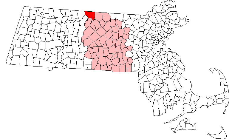
mapsize = 250px
map_caption = Location in Worcester County in Massachusetts
mapsize1 =
map_caption1 =
subdivision_type = Country
subdivision_name =United States
subdivision_type1 = State
subdivision_name1 =Massachusetts
subdivision_type2 = County
subdivision_name2 = Worcester
established_title = Settled
established_date = 1762
established_title2 = Incorporated
established_date2 = 1765
established_title3 =
established_date3 =
government_type =Open town meeting
leader_title =
leader_name =
leader_title1 =
leader_name1 =
area_magnitude =
area_total_km2 = 110.0
area_total_sq_mi = 42.5
area_land_km2 = 108.5
area_land_sq_mi = 41.9
area_water_km2 = 1.5
area_water_sq_mi = 0.6
population_as_of = 2000
settlement_type = Town
population_total = 1254
population_density_km2 = 11.5
population_density_sq_mi = 29.9
elevation_m = 309
elevation_ft = 1015
timezone = Eastern
utc_offset = -5
timezone_DST = Eastern
utc_offset_DST = -4
latd = 42 |latm = 40 |lats = 39 |latNS = N
longd = 72 |longm = 11 |longs = 18 |longEW = W
website =
postal_code_type = ZIP code
postal_code = 01368
area_code = 351 / 978
blank_name = FIPS code
blank_info = 25-58580
blank1_name = GNIS feature ID
blank1_info = 0619488
footnotes =Royalston is a town in Worcester County,
Massachusetts ,United States . The population was 1,254 at the 2000 census.History
Royalston is a small town in the North Quabbin area of North Western-Central Massachusetts. It is very large in land area (about 42.6 square miles) though it has a tiny population of about 1200. Most of the town's land is forest and wetlands and there are a lot of reservations and wildlife management areas. Many of the surrounding towns like Warwick and Richmond are also very small. Two notable reservations are the Tully Lake flood protection dam area in the very southwestern part of the town, and the Royalston Falls reservation in the northern section. The largest population center in the town is the village of South Royalston in the southwestern corner of the town. This village contains the town's only store, a small convenience store and deli, and its only restaurant. The center of town is also a small village that contains a very well preserved classic colonial New England town center and common. The center of town contains the town hall, post office, congregational church, and the town's library.
The small part-time police and fire forces cooperate with the Athol and State police for more serious needs. The town also does not have a central office for the phone company and uses the phone exchanges for Athol. The residents of the town are devoted to keeping the town a classic and quiet New England town and have taken mesaures to prevent the town from having the developments that have grown in many small towns in Western Massachusetts. Internet access is limited due to the unwillingness of the cable companies to wire the whole town. DSL is slowly creeping up from Athol. The town Government recently acquired a T1 for the South Royalston town offices. This may become a wireless hub for local residents. Most residents are required to get satellite providers for cable TV and internet services or settle for dialup. The town has no business zoning. To shop for groceries and basic items, residents go either south to Orange and Athol, west to Winchester, NH, north to Keene, NH, east to Rindge, NH or Winchendon, MA. For work, retail shopping, and general business, you have to drive at least 25-30 minutes to get to a population area. Most people in the town either go North to the Keene area, or towards Gardner, Fitchburg, and Leominster, or south to Amherst.
Geography
Royalston is located in northwestern-central Massachusetts. It is the northwestern corner of Worcester County. It borders Athol and Phillipston to the south, Templeton to the southeast, Winchendon to the east, Richmond and Fitzwilliam in Cheshire County New Hampshire to the north, Warwick in Franklin County to the west, and Orange in Franklin County to the southwest. According to the
United States Census Bureau , the town has a total area of 42.5square mile s (110.0km² ), of which, 41.9 square miles (108.5 km²) of it is land and 0.6 square miles (1.5 km²) of it (1.39%) is water.Demographics
As of the
census GR|2 of 2000, there were 1,254 people, 449 households, and 330 families residing in the town. Thepopulation density was 29.9 people per square mile (11.6/km²). There were 526 housing units at an average density of 12.6/sq mi (4.8/km²). The racial makeup of the town was 98.64% White, 0.08% African American, 0.56% Asian, 0.16% from other races, and 0.56% from two or more races. Hispanic or Latino of any race were 1.12% of the population. 15.8% were of French, 13.0% English, 11.2% Irish, 10.5%French Canadian , 8.5% American, 7.3% Finnish and 7.2% Italian ancestry according toCensus 2000 .There were 449 households out of which 36.1% had children under the age of 18 living with them, 61.7% were married couples living together, 7.1% had a female householder with no husband present, and 26.5% were non-families. 20.5% of all households were made up of individuals and 7.1% had someone living alone who was 65 years of age or older. The average household size was 2.79 and the average family size was 3.27.
In the town the population was spread out with 29.1% under the age of 18, 5.8% from 18 to 24, 29.9% from 25 to 44, 25.4% from 45 to 64, and 9.8% who were 65 years of age or older. The median age was 38 years. For every 100 females there were 107.3 males. For every 100 females age 18 and over, there were 110.2 males.
The median income for a household in the town was $44,444, and the median income for a family was $51,818. Males had a median income of $36,328 versus $27,361 for females. The
per capita income for the town was $18,297. About 5.4% of families and 8.7% of the population were below thepoverty line , including 10.1% of those under age 18 and 6.5% of those age 65 or over.Government
Infobox Mass Town Govt
county= Worcester
clerk_courts = Dennis P. McManus (D)
cty_treasurer = Position Eliminated
da = Joseph D. Early, Jr. (D)
deeds = Anthony J. Vigliotti (D)
probate = Stephen Abraham (D)
sheriff = Guy W. Glodis (D)
state_rep = Robert L. Rice (D)
state_sen = Stephen M. Brewer (D)
gov_councilors = Thomas J. Foley (D)
fed_rep =John W. Olver (D-1st District),
fed_sen =Edward Kennedy (D)John Kerry (D)Education
The town's only public school, the Royalston Community school (a public elementary school), is located east of the town center on the road to Winchendon. The school only covers the lower grades, and for middle and high school the town is part of the Athol school district.
There is also an independent school, called [http://www.villageschool.to The Village School] located on the Common. It serves students from Royalston and surrounding towns; covering grades preschool through 6th. They are currently working on building a new school on South Royalston Road at the former Camp Caravan property and plan to move to the building for the 2009-2010 school year.
Notable residents
Hometown of Kendall Divoll, drummer of Necronomichrist and Alabaster Wormwood, also former member of Complex-I, Ninth Order of Angels, and The Ethan Stone Band; Justice Dunn studio musician and former member of Blackened Chapel and War-Dogz.
External links
* [http://www.royalston-ma.gov Royalston official website]
Wikimedia Foundation. 2010.