- Càrn nan Gobhar (Mullardoch)
-
Càrn nan Gobhar 
Càrn nan Gobhar seen from Sgurr na Lapaich, 2.5 km to the NW.Elevation 992 m (3,255 ft) Prominence 196 m (643 ft) Listing Munro, Marilyn Translation Cairn of the Goat (Gaelic) Pronunciation Scottish Gaelic: [ˈkʰaːrˠn nəŋ ˈko.əɾ]
English approx:
karn nuhn KOE-erLocation Location Highland,  Scotland
Range Northwest Highlands Topo map OS Landranger 25, OS Explorer 430 OS grid NH181343 Listed summits of Càrn nan Gobhar (Mullardoch) Name Grid ref Height Status Creag Dubh NH199350 946 m (3103 ft) Munro Top  The view north from the summit to Loch Monar and Glen Strathfarrar.
Càrn nan Gobhar is a Scottish mountain situated on the northern side of Loch Mullardoch in the upper part of Glen Cannich. It stands some 50 kilometres west-southwest of the city of Inverness in a remote group of four Munros informally known as “The Mullardochs” which form the high ground between Loch Mullardoch and Loch Monar.
Contents
Overview
Càrn nan Gobhar reaches a height of 992 metres (3254 feet) and qualifies as a Munro and a Marilyn. Somewhat confusingly there is another Càrn nan Gobhar, also a Munro with exactly the same height situated 14 kilometres to the north east on the northern side of Glen Strathfarrar, the two should not be confused. Càrn nan Gobhar is the smallest of the four Mullardochs and is rather overshadowed by them in height. Topographically it is quite featureless being mainly composed of rolling grassy slopes interspersed with patches of rock and scree although there are steeper slopes on the west and east flanks. The hills name translates from the Gaelic as “Cairn (i.e. hill) of the Goats”[1]
Geography
Càrn nan Gobhar is composed of three main ridges giving the mountain a rough triangular shape. The 3.5 km long SSE ridge goes over the subsidiary top of Mullach na Moille (761 metres) before swinging more easterly and dropping down to the eastern end of Loch Mullardoch. The north western ridge links to the adjoining Munro of Sgurr na Lapaich across the Bealach na Cloiche Duibhe which has a height of 796 metres. A third ridge goes north east for two km and connects to the Munro “Top” of Creag Dubh (946 metres). Creag Dubh was initially named as a Munro in Sir Hugh Munro’s origin list of 1891 but was downgraded to a top in 1921. It has just under 100 metres of prominence from the main summit and its north eastern slopes are initially rocky as they drop down to the Glen Strathfarrar Forest.[2]
Càrn nan Gobhar’s best feature is its south facing corrie of Coire an t-Sith (Corrie of the Fairies) it is drained by the Allt Mullardoch which descend to Loch Mullardoch in a series of small waterfalls. The corrie carries a well constructed stalkers path which can be well utilised when doing a high level circuit of the corrie which takes in the Munro summit and the “top”. All drainage from the mountain goes to the east coast of Scotland at the Beauly Firth via the glens of Strathfarrar or Cannich.
Ascent and summit
The best starting point for the ascent of Càrn nan Gobhar is the parking spot at the end of the public road in Glen Cannich by the Loch Mullardoch dam at grid reference NH219315. The route follows the northern shore of the loch for 1.5 km before ascending steeply up the SSE ridge passing over Mullach na Moille on the way to the summit. The mountain is often climbed in conjunction with Sgurr na Lapaich and strong walkers will also take in the other two Mullardoch Munros of An Riabhachan and An Sochach.[3]
The summit of the mountain is basically a flat broad north-south ridge but there are two definite high points, 200 metres apart and both with cairns. The southern cairn is bigger and stands at an approximate height of 985 metres, the true northern summit has a smaller cairn and gives good views north to the Monar Forest Munros of Maoile Lunndaidh and Lurg Mhor. It is also a good viewpoint for the corries and cliffs of the close at hand Sgurr na Lapaich.[4]
References
- The Munros, Scottish Mountaineering Trust, 1986, Donald Bennett (Editor) ISBN 0-0907521-13-4
- The High Mountains of Britain and Ireland, Diadem, 1993, Irvine Butterfield, ISBN 0-906371-30-9
- The Munros, Scotland's Highest Mountains, Cameron McNeish, ISBN 1-84204-082-0
- 100 Best Routes on Scottish Mountains, Ralph Storer, ISBN 0-7515-0300-2
- Hamish’s Mountain Walk, Baton Wicks, 1996, Hamish Brown, ISBN 1-898573-08-5
Footnotes
- ^ "The High Mountains of Britain and Ireland" Page 318 Gives translation as “Cairn of the Goats“; "The Munros" Page 180 Gives translation as “Hill of the Goats“.
- ^ Online version of Munros Tables. Gives details of Creag Dubh.
- ^ "The Munros" Page 180 Gives details of routes of ascent.
- ^ "Hamish‘s Mountain Walk" Page 269 Gives details of summit cairns.
 An Riabhachan · An Socach · Bidein a' Choire Sheasgaich · Càrn nan Gobhar (Mullardoch) · Càrn nan Gobhar (Strathfarrar) · Lurg Mhòr · Maoile Lunndaidh · Mòruisg · Sgurr a' Chaorachain · Sgurr a' Choire Ghlais · Sgurr Choinnich · Sgurr Fhuar-thuill · Sgurr na Lapaich · Sgurr na Ruaidhe
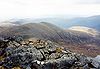
List of Munros Categories:- Munros
- Marilyns of Scotland
- Mountains and hills of the Northwest Highlands


Wikimedia Foundation. 2010.