- Whitefield, Maine
-
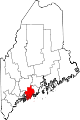
Whitefield, Maine — Town — Location within the state of Maine
 Whitefield, Maine
Coordinates: 44°12′36″N 69°36′15″W / 44.21°N 69.60417°W Country United States State Maine County Lincoln Area - Total 47.5 sq mi (123.1 km2) - Land 46.8 sq mi (121.3 km2) - Water 0.7 sq mi (1.8 km2) Elevation 108 ft (33 m) Population (2000) - Total 2,273 - Density 48.5/sq mi (18.7/km2) Time zone Eastern (EST) (UTC-5) - Summer (DST) EDT (UTC-4) ZIP code 04353 Area code(s) 207 FIPS code 23-85010 GNIS feature ID 0582811 Whitefield is a town in Lincoln County, Maine, United States. The population was 2,273 at the 2000 census. Whitefield is named for the celebrated British evangelist George Whitefield, who inspired the colonists before the town was settled in 1770, mainly by Irish Catholics.[1] They remembered him when incorporation came in 1809.
Contents
Geography
According to the United States Census Bureau, the town has a total area of 47.5 square miles (123 km2), of which, 46.8 square miles (121 km2) of it is land and 0.7 square miles (1.8 km2) of it (1.47%) is water.
Demographics
As of the census[2] of 2000, there were 2,273 people, 844 households, and 620 families residing in the town. The population density was 48.5 people per square mile (18.7/km²). There were 954 housing units at an average density of 20.4 per square mile (7.9/km²). The racial makeup of the town was 97.23% White, 0.18% African American, 1.23% Native American, 0.35% Asian, 0.18% Pacific Islander, 0.13% from other races, and 0.70% from two or more races. Hispanic or Latino of any race were 0.88% of the population.
There were 844 households out of which 35.7% had children under the age of 18 living with them, 61.1% were married couples living together, 8.6% had a female householder with no husband present, and 26.5% were non-families. 20.0% of all households were made up of individuals and 5.9% had someone living alone who was 65 years of age or older. The average household size was 2.62 and the average family size was 3.02.
In the town the population was spread out with 26.4% under the age of 18, 5.6% from 18 to 24, 29.5% from 25 to 44, 26.8% from 45 to 64, and 11.7% who were 65 years of age or older. The median age was 38 years. For every 100 females there were 98.0 males. For every 100 females age 18 and over, there were 97.6 males.
The median income for a household in the town was $38,477, and the median income for a family was $41,994. Males had a median income of $27,917 versus $21,750 for females. The per capita income for the town was $16,456. About 8.2% of families and 12.5% of the population were below the poverty line, including 14.6% of those under age 18 and 19.9% of those age 65 or over.
References
- ^ Maine League of Historical Societies and Museums (1970). Doris A. Isaacson. ed. Maine: A Guide 'Down East'. Rockland, Me: Courier-Gazette, Inc.. pp. 160.
- ^ "American FactFinder". United States Census Bureau. http://factfinder.census.gov. Retrieved 2008-01-31.
External links
- Town Page - history, newsletters, illustrated timeline
- Maine Genealogy: Whitefield, Lincoln County, Maine
Municipalities and communities of Lincoln County, Maine County seat: Wiscasset Towns Alna | Boothbay Harbor | Boothbay | Bremen | Bristol | Damariscotta | Dresden | Edgecomb | Jefferson | Newcastle | Nobleboro | Somerville | South Bristol | Southport | Waldoboro | Westport Island | Whitefield | Wiscasset
Plantation Gore CDPs Other
villagesCategories:- Towns in Lincoln County, Maine


Wikimedia Foundation. 2010.