- Dunsum
-
Dunsum 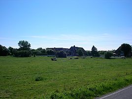

 DunsumLocation of Dunsum within Nordfriesland district
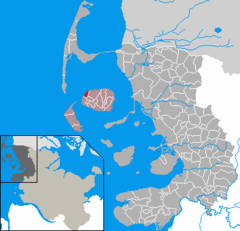
Coordinates 54°43′N 8°22′E / 54.71667°N 8.36667°ECoordinates: 54°43′N 8°22′E / 54.71667°N 8.36667°E Administration Country Germany State Schleswig-Holstein District Nordfriesland Municipal assoc. Föhr-Amrum Mayor Arfst Christiansen Basic statistics Area 2.72 km2 (1.05 sq mi) Elevation 0 m (0 ft) Population 64 (31 December 2010)[1] - Density 24 /km2 (61 /sq mi) Other information Time zone CET/CEST (UTC+1/+2) Licence plate NF Postal code 25938 Area code 04683 Website www.dunsum.de Dunsum (Fering: Dunsem) is a municipality located on the western shore of Föhr in the district of Nordfriesland, in Schleswig-Holstein, Germany. It is composed of the districts of Greater and Lesser Dunsum.
Contents
Geography and traffic
From Dunsum, guided mudflat hikings to the neighbouring island of Amrum are offered at low tide. Amrum and Sylt can be seen from there. In the tidal flats north of the village the Baalkstian is located, a large glacial erratic, which was destroyed during a storm surge. The tale has it, that a treasure is hidden below the rock, yet it has never been found.
Bus lines connect Dunsum to the other villages of the island and to the town of Wyk auf Föhr.
History
The name means "Donni's settlement".
As a part of Westerland Föhr, Dunsum belonged to the Royal Enclaves of Denmark and thus was a direct part of the Danish crown while Osterland Föhr belonged to the duchy of Schleswig. Only when Denmark lost Schleswig to Prussia in the Second Schleswig War, Dunsum became a part of Schleswig-Holstein.
Politics
Since the communal elections of 2008 the Dunsumer Wählergemeinschaft holds all seven seats of the municipality council.
References
- ^ "Statistikamt Nord: Bevölkerung in Schleswig-Holstein am 31. Dezember 2010 nach Kreisen, Ämtern, amtsfreien Gemeinden und Städten" (in German). Statistisches Amt für Hamburg und Schleswig-Holstein. 31 December 2010. http://www.statistik-nord.de/uploads/tx_standocuments/A_I_2_vj104_S.pdf.
External links
Categories:- Municipalities in Schleswig-Holstein


Wikimedia Foundation. 2010.