- Chaliyar River
-
Chaliyar River Chaliyar, Chaliyarpuzha Country India States Kerala, Tamil Nadu District Kozhikode Tributaries - left Iruvazhinjipuzha, Cherupuzha, Engappuzha - right Cherupuzha Nilambur City Nilambur, Edavanna, Areekode,
Kizhuparamba, cheekode, Vazhakkad, Cheruvadi,
Mavoor, Peruvayal, Aakode, Feroke,
Beypore.Source Kakkadampoyil Clif - location Western Ghats, South India, India - elevation 11.183 m (37 ft) - coordinates 11°10′59″N 75°49′01″E / 11.183°N 75.817°E Mouth - location Beypore, Arabian Sea, India - elevation 0 m (0 ft) Length 100 km (100 mi) approx.  Labelled map of Chaliyar
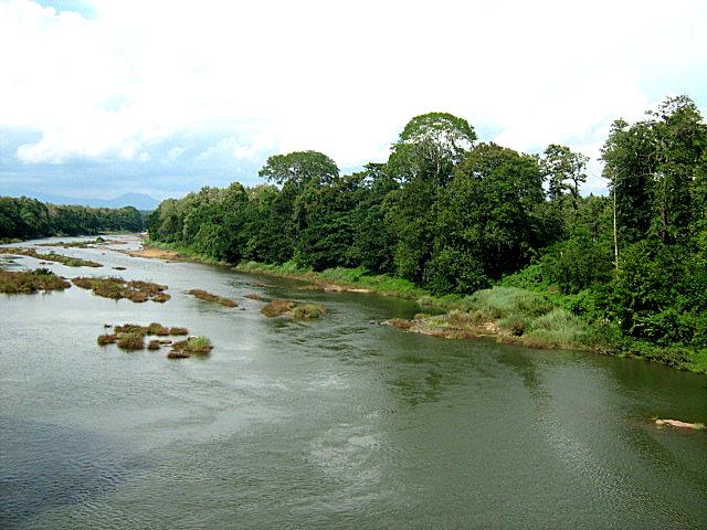
 Chaliyar River in Nilambur of Malappuarm District
Chaliyar River is the fourth longest river in Kerala at 169 km in length. The Chaliyar river is also known as Beypore River as it nears the sea. Nilambur, Edavanna, Areekode, Kizhuparamba, Cheruvadi, Mavoor, Peruvayal, Feroke and Beypore are some of the towns/villages situated along the banks of Chaliyar River.
Contents
Name
The river has two names - Chaliyar and Beypore River, of which the former is more popular. The river meets the Arabian Sea at an 'azhi' (estuary), the southern part of which is known as Chaliyam and northern part as Beypore. Thus the river gets the names Chaliyar and Chaliyar River.
CHALIYAR AND FEROKE BRIDGE
Chaliyar is one of the rivers which doesn't get dried up in the drought season.Many other rivers in Kerala get dried up during march and April.
Course
The Chaliyar originates in the Western Ghats range at Elambalari Hills located near Cherambadi town in the Nilgiris district of Tamil Nadu and flows through Malappuram District for most of its length and then for around 17 km it forms the boundary between Malappuram District and Kozhikode District before entering the city of Kozhikode for its final 10 km journey and finally empties into the Arabian Sea. Some of the Chaliyar's tributaries originate from Wayanad District and joins the main river in Malappuram.Near the origin of river are the Meenmutty Falls at coordinates 11°31′40″N 76°14′12″E / 11.5277551°N 76.2365341°E by Vaduvanchal, Wayanad
Economy
During late 19th century and early 20th century, the Chaliyar was extensively used as a waterway for carrying timber from the forest areas in and around Nilambur to the various mills in Kallai of Calicut city. Rafts made of logs were taken downstream during the monsoon season to Kallayi, where these were sawn to size in the timber mills dotting the banks of the river. Kallai was during this period one of the most important centers in the world for timber business. The place was famous for wood of superlative strength and durability like teak, rosewood, etc. Towards the second half of the 20th century, the activity came down drastically as tree felling was banned or strictly controlled with a view to stop deforestation. Many mills still operate in Kallai, though with far less output. Many have closed down.
Ecology
 Hanging bridge across Chaliyar River in Nilambur, which connects to Conolly Teak Plantation.
Chaliyar River was in the news a few years ago because of the ecological damage caused by a pulp factory at Mavoor, that released effluents into the river and affected the marine life. This factory has since closed down.
 Turbulent Chaliyar in Feroke during heavy monsoon season
History
- Legend of the Chaliyar
- Chaliyar Agitation K A Rahman
- Anti Pollution Committee Paristhithi Samrakshana Samithi
Tributaries
- Website www.chaliyar.in
- Cherupuzha (Mavoor)
- Engappuzha
- Iruthullippuzha
- Kadungampuzha
- Iruvanjippuzha
- Pulingappuzha
- Chalippuzha
- Muthappanpuzha
- Cherupuzha (Areekode)
- Kuthirappuzha
- Kuruvanpuzha
- Kanjirappuzha
- Karimpuzha
- Cherupuzha (Karulai)
- Punnappuzha or Pandiyar
- Maruthappuzha or Kalakkanpuzha
- Pandippuzha
- Neerppuzha
In addition to these rivers some creeks also join Chaliyar from Neelithode, Poonkudi, Vadasseri, Edavanna, Kunduthodu and Mampad.
References
- "Infobox facts". All Kerala River Protection Council. http://puzhakal0.tripod.com/river.html. Retrieved August 27, 2005.
- Website www.chaliyar.in
- The River Chaliyar, by M. P. Chandran
- About the Rivers of Kerala
- K A Rahman
External links
- Chaliyar River and Mayladi Bridge Nilambur
- Website www.chaliyar.in
- News report about the River after the pulp factory was closed.
- Life returns to Chaliyar river
- Adyanpara waterfalls
Categories:- Rivers of Kerala


Wikimedia Foundation. 2010.