- Oldberrow
-
Coordinates: 52°17′N 1°49′W / 52.28°N 1.82°W
Oldberrow 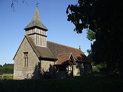
St Marys Church
 Oldberrow
Oldberrow shown within WarwickshirePopulation 153 (2001 Census) OS grid reference SP1265 District Stratford on Avon Shire county Warwickshire Region West Midlands Country England Sovereign state United Kingdom Police Warwickshire Fire Warwickshire Ambulance West Midlands EU Parliament West Midlands UK Parliament Stratford-on-Avon (UK Parliament constituency), List of places: UK • England • Warwickshire Oldberrow is a village in the Stratford on Avon District of Warwickshire, England. The parish was part of Worcestershire until 1896, when it was transferred to Warwickshire, into which county it penetrated, between Morton Bagot and Ullenhall, as a narrow strip some 3 miles (4.8 km) long by about ½ mile wide. The land slopes from 513 ft (156 m). at Oldberrow Hill in the north-west to about 275 ft (84 m). in the south-east. There is no village, but the church, rectory, and the Court lying at the crossing of four small roads.[1][1] It is now part of the parish of Morton Bagot, Oldberrow and Spernall which in 2001 had a population of 153.
Contents
History
Its name first appears in 709 when Cenred of Mercia gave 12 acres (49,000 m2) in Oldberrow to Bishop Egwin towards the endowment of his newly founded monastery at Evesham. the spelling at this time was Ulenbeorge meaning either "the hill of the owl"[2] or "Ulla's hill".[3] It has gone through many variations of spelling, Oleburgh in the Domesday Book, Ullebury in the 1332 Subsidy Roll, then Owlburough, Uleberga, Oldborough, Oldbarrow and Oldburrow.[2] The hill is about 2 miles (3.2 km) from the church and was described by Treadway Nash as an ancient tumulus[4] In 1086, it was still held by the church at Evesham and is recorded; In Fishborough Hundred... In Oleburgh (Oldberrow) are 12 acres (49,000 m2) of land. 2 countrymen, pigmen. Woodland, 1 league. Value 5s[5]
Governance
Oldberrow is part of the Sambourne ward of Stratford on Avon District Council and represented by Councillor Justin Kerridge, Conservative [2]. Nationally it is part of Stratford-on-Avon, whose current Member of Parliament following the 2010 election is Nadhim Zahawi of the Conservative Party.It is included in the West Midlands electoral region of the European Parliament and the 6 Members are; Mike Nattrass (UK Independence), Liz Lynne (Liberal Democrat), Malcolm Harbour (Conservative), Michael Cashman (Labour), Philip Bradbourn OBE (Conservative) and Nicole Sinclaire (UK Independence).
Notable buildings
The church, dedicated to St Mary is a small building of stone rebuilt in 1875 the cost of £1256 largely being borne by the then rector, the Reverend Samuel Peshall who was rector for 60 years and the third generation of his family to hold the post.[2] Despite the rebuilding some earlier features remain, two 12th century windows, a lancet window of the 13th century and the 14th century south doorway, the one to north is of the 15th century and is blocked up. In the chancel there is a 12th century piscina (restored) and an aumbury whilst the font has an archaic bowl with octagonal panels sculptured with foliage designs.[6] The east window to the memory of the Reverend Samuel D'Oyley Peshall rector between 1792 and 1859, contains a piece of old glass bearing the arms of Evesham Abbey whilst the west window is dedicated to Canon Warren who became rector in 1933. The small turret contains three bells one of which is of an ancient long waisted type which may be 13th century, the others are by John Martin of Worcester and dated 1674.[2] The puritan "Survei of the Ministrie in Warwickshier" of 1586 has some harsh words for the then Rector; "Geoffrie Heath parson dumbe idle and popish a verie dissolute man of life, he married first another mans wife, got a maide with childe, married a third; a common alehouse haunter and useth in(cantation) to plaie after a sorte the reconciler amongest the simple; value xx markes by the yeare".[7][3]
-

East Window of St Marys
-

West window of St Marys dedicated to Canon Warren
-
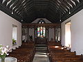
Interior of St Marys church
-

St Marys church the font
-

St Marys church showing encaustic tiles in front of the Altar
References
- ^ A History of the County of Warwick: Volume 3: Barlichway hundred (1945)
- ^ a b c d Warwickshire People and Places, John Burman 1936
- ^ Place names in the Landscape, Margaret Gelling, 1984 ISBN 0-460-04380-3
- ^ Collections for the History of Worcestershire, Rev. Treadway Nash, 1781
- ^ Domesday Book for Warwickshire, Phillimore edited by John Morris ISBN 0 85033 141 2
- ^ Old Warwickshire Churches, W. Hobart Bird 1936
- ^ Survei of the Ministrie in Warwickshier 1586
External links
 Media related to Oldberrow at Wikimedia CommonsCategories:
- Villages in Warwickshire
-


Wikimedia Foundation. 2010.