- Cratfield
-
Coordinates: 52°16′01″N 1°31′48″E / 52.267°N 1.53°E
Cratfield 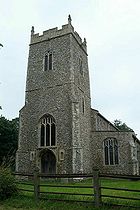
Church of St Mary, Cratfield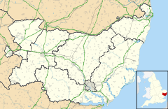
 Cratfield
Cratfield shown within SuffolkPopulation 299 [1] (2001 census) OS grid reference TM 315 755 GB Grid Shire county Suffolk Region East Country England Sovereign state United Kingdom Post town Halesworth Dialling code 01986 EU Parliament East of England List of places: UK • England • Suffolk Cratfield is a village in northern Suffolk, England.
Neighbouring villages include Laxfield, Metfield, Cookley, Huntingfield, Heveningham. The nearest town, Halesworth, is approximately 5 miles (8 km) away. Southwold is a popular, nearby coastal town. The market town of Framlingham is also close by.
Cratfield is a small farming and residential community. It currently has no shop, but has a pub, The Cratfield Poacher, and several bed and breakfast hotels. Cratfield is also home to St Mary's Church (15th/16th century) — built of flint, mainly Perpendicular and noted particularly for its very fine font.
References
External links
 Media related to Cratfield at Wikimedia Commons
Towns Civil parishes Alderton · Aldringham cum Thorpe · Badingham · Bawdsey · Benhall · Blaxhall · Blythburgh · Boulge · Boyton · Bramfield · Brandeston · Bredfield · Brightwell · Bromeswell · Bruisyard · Bucklesham · Burgh · Butley · Campsea Ashe · Capel St Andrew · Charsfield · Chediston · Chillesford · Clopton · Cookley · Cransford · Cratfield · Cretingham · Culpho · Dallinghoo · Darsham · Debach · Dennington · Dunwich · Earl Soham · Easton · Eyke · Falkenham · Farnham · Foxhall · Framlingham · Friston · Gedgrave · Great Bealings · Great Glemham · Grundisburgh · Hacheston · Hasketon · Hemley · Heveningham · Hollesley · Hoo · Huntingfield · Iken · Kelsale cum Carlton · Kesgrave · Kettleburgh · Kirton · Knodishall · Letheringham · Levington · Linstead Magna · Linstead Parva · Little Bealings · Little Glemham · Marlesford · Martlesham · Melton · Middleton · Monewden · Nacton · Newbourne · Otley · Parham · Peasenhall · Pettistree · Playford · Purdis Farm · Ramsholt · Rendham · Rendlesham · Rushmere St Andrew · Saxtead · Shottisham · Sibton · Snape · Sternfield · Stratford St Andrew · Stratton Hall · Sudbourne · Sutton · Swefling · Swilland · Theberton · Thorington · Trimley St Martin · Trimley St Mary · Tuddenham St Martin · Tunstall · Ubbeston · Ufford · Walberswick · Waldringfield · Walpole · Wantisden · Wenhaston with Mells Hamlet · Westerfield · Westleton · Wickham Market · Witnesham · YoxfordOther settlements See also: Listed buildings · Local elections Categories:- Suffolk Coastal
- Villages in Suffolk
- Civil parishes in Suffolk
- Suffolk geography stubs


Wikimedia Foundation. 2010.