- Magherafelt
-
Coordinates: 54°45′N 6°37′W / 54.75°N 6.61°W
Magherafelt Irish: Machaire Fíolta 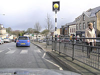
 Magherafelt
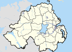
Magherafelt shown within Northern IrelandPopulation 8,372 (2001 Census) - Belfast 35 miles District Magherafelt County County Londonderry Country Northern Ireland Sovereign state United Kingdom Post town MAGHERAFELT Postcode district BT45 Dialling code 028 Police Northern Ireland Fire Northern Ireland Ambulance Northern Ireland EU Parliament Northern Ireland UK Parliament Mid Ulster NI Assembly Mid Ulster List of places: UK • Northern Ireland • County Londonderry Magherafelt (from Irish: Machaire Fíolta meaning "plain of Fíolta")[1] is a small town in County Londonderry, Northern Ireland. It had a population of 8,372 people recorded in the 2001 Census. It is the biggest town in the south of County Londonderry and is the social, economic and political hub of the area. Magherafelt District Council is headquartered in the town.
Contents
History
Magherafelt is a Plantation town built around a central diamond, which forms the heart of the town. However, the origins of the town predate the Plantation and go back to 1425. During the Northern Irish Troubles in the late twentieth century eleven people were killed in or near Magherafelt in connection with the conflict.
See also: The Troubles in MagherafeltTransport
- Magherafelt railway station opened on 10 November 1856, closed for passenger traffic on 28 August 1950 and finally closed altogether on 1 October 1959.[2]
Schools in Magherafelt
- Kilronan Special School
- Gaelscoil an tSeanchaí
- Naíscoil an tSeanchaí
- Woods Primary School
- Magherafelt Controlled Primary School
- Holy Family Primary School
- Saint Pius X College
- Rainey Endowed School
- St. Mary's Grammar School
- Magherafelt High School
- Sperrin Integrated College
- Spires Integrated Primary School
Sport
Magherafelt has several sporting teams, consisting of O'Donovan Rossa Magherafelt GAC, the Rainey Old Boys Rugby Club, Magherafelt Sky Blues F.C. and Magherafelt Reds.
2001 Census
Magherafelt is classified as a small town by the Northern Ireland Statistics and Research Agency (NISRA) (i.e. with population between 4,500 and 10,000 people). On Census day (29 April 2001) there were 8,372 people living in Magherafelt. Of these:
- 27.1% were aged under 16 years and 13.7% were aged 60 and over
- 48.7% of the population were male and 51.3% were female
- 56.2% were from a Catholic background and 41.8% were from a Protestant background
- 3.4% of people aged 16–74 were unemployed.
For more details see: NI Neighbourhood Information Service
People
- Peter Doherty - former footballer and manager of Northern Ireland[3]
- Barry Gillis - Current Derry Gaelic footballer
- Joe Keenan - Current Derry Gaelic footballer
- Frank Niblock - Former Derry Gaelic footballer
- Mickey Niblock - Former Derry Gaelic footballer
- Willie McCrea (born 6 August 1948), former MP for Mid Ulster from 1983-1997. He took South Antrim at a by-election in 2000, but failed to retain this seat at the 2001 election. In the 2005 election he regained the seat. He has been a member of the Northern Ireland Assembly for Mid Ulster. At the 2007 election, he was elected as Assembly Member for South Antrim.
- Laura Pyper - actress (Hex, Reign of Fire and Headrush)
- Dean Shiels - professional association football player
- Terry McFlynn - a current football player for Sydney FC was born in Magherafelt but raised in Swatragh; former Northern Ireland Under 21 player
- Sir James Starritt, KCVO (born 15 May 1914, Carrigans, County Donegal — died 2001) was the son of a land auctioneer His family were staunchly Presbyterian. The family moved to Magherafelt after the Irish Civil War. He attended Rainey Endowed School in Magherafelt. He joined the Metropolitan Police in 1935 at Paddington. During the Second World War, he served with the Royal Marines in the Far East, rising to captain. Returning to the Met, he was promoted sergeant in 1947 and by 1955 was a chief inspector. He was a Deputy Commissioner of the Metropolitan Police from 1972-75 when he retired. Upon his retirement he was appointed KCVO.
- Paul Charles - novelist, music promoter and talent agent
- Thomas Niblock - Television sports presenter for BBC Newsline
- General Fiasco - Indie Rock Band from Magherafelt who have released one studio album and have received much critical acclaim in the UK.
- Colm Mc Gurk- All Ireland medalist in gaelic and hurling played for derry along with brother Johnny Mc Gurk man of the match 1993 .
References
- ^ Placenames Database of Ireland
- ^ "Magherafelt station". Railscot - Irish Railways. http://www.railscot.co.uk/Ireland/Irish_railways.pdf. Retrieved 2007-11-03.
- ^ Peter Doherty
Sources
External links
Towns in Northern Ireland List of towns by populationLarge Antrim · Ballymena · Bangor · Carrickfergus · Coleraine · Larne ·
Lisburn · Lurgan · Newry · Newtownabbey · Newtownards · Omagh · Portadown
Medium Small Ballycastle · Ballyclare · Ballymoney · Ballynahinch · Carryduff · Coalisland · Comber · Donaghadee ·
Drumore · Kilkeel · Magherafelt · Newcastle · Portrush · Portstewart · Randalstown · WarrenpointCategories:- Towns in County Londonderry


Wikimedia Foundation. 2010.