- Pennsylvania Route 449
-
PA Route 449
Route information Maintained by PennDOT Length: 17.1 mi[1] (28 km) Existed: 1961 – present Major junctions South end:  US 6 in Walton
 PA 49 in Gold
 PA 244 in Genesee Township.
North end:  NY 19 at the New York state line in Genesee Township.
Location Counties: Potter Highway system Roads in Pennsylvania
Interstate • US • State • Legislative←  PA 447
PA 450  →
→Pennsylvania Route 449 (PA 449) is an 17-mile (27 km) long state highway located in Potter county in Pennsylvania. The southern terminus is at US 6 in Walton. The northern terminus is the New York state line in Genesee Township.
Route description
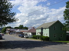 PA 244/PA 449 in Genesee Township
PA 449 begins at an intersection with US 6 in the community of Walton in Ulysses Township, heading northwest on Brookland Road. The road heads through forested mountains in the Susquehannock State Forest before coming to the community of Brookland. After passing through more forests, the route enters agricultural areas and becomes Gold Road, intersecting PA 49 in the community of Gold. From this point, PA 449 turns north and continues through a mix of farmland and woodland in a narrow valley. The road briefly enters Allegany Township before heading into Genesee Township and passing through the community of Harmontown. The route runs through more rural areas before intersecting PA 244 in the community of Genesee. Here, PA 244 turns north to form a concurrency with PA 449 on Main Street, with the road passing homes and businesses. PA 449 splits from PA 244 by heading northwest on North Genesee Street into a mix of farms, woods, and homes. PA 449 ends at the New York border, where the road becomes NY 19.[1][2]
Major intersections
The entire route is in Potter County.
Location Mile Destinations Notes Walton US 6 (Grand Army of the Republic Highway)Southern terminus Gold PA 49Genesee PA 244 south (Ellisburg Road)South end of PA 244 overlap PA 244 northNorth end of PA 244 overlap New York State Line NY 19 north (Stannards Road)Northern terminus, continues as NY 19 1.000 mi = 1.609 km; 1.000 km = 0.621 mi References
- ^ a b Google, Inc. Google Maps – overview of Pennsylvania Route 449 (Map). Cartography by Google, Inc. http://maps.google.com/maps?f=d&source=s_d&saddr=US+6+and+south+brookland+road&daddr=north+genesee+street+and+stannards+road&geocode=FZWnfQIdlWld-ylnOg4WwwTOiTErOMXiWC62YA%3BFW3YgAIdcKJb-ylRV0WhJ_nRiTEPsIg95gS0Qw&hl=en&mra=ls&sll=41.999496,-77.883711&sspn=0.028703,0.084543&ie=UTF8&t=h&z=11. Retrieved March 5, 2011.
- ^ PennDOT (2011). Potter County, Pennsylvania Highway Map (Map). ftp://ftp.dot.state.pa.us/public/pdf/BPR_pdf_files/Maps/GHS/Roadnames/potter_GHSN.PDF. Retrieved March 5, 2011.
Categories:- State highways in Pennsylvania


Wikimedia Foundation. 2010.