Makemo

Makemo

Makemo

MakemoISS005-E-15031.PNG
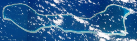
NASA picture of Makemo Atoll.
Localización de Makemo en las Tuamotu.png
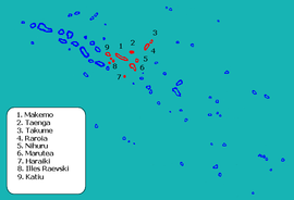
Location of Makemo in the Tuamotu Archipelago
Administration
Country France
Overseas collectivity French Polynesia
Administrative subdivision Îles Tuamotu-Gambier
Statistics
Land area 100 km2 (39 sq mi)
Population1 1,422  (2007)
 - Density 14 /km2 (36 /sq mi)
1 Population without double counting: residents of multiple communes (e.g., students and military personnel) only counted once.

Coordinates: 16°35′55″S 143°39′41″W / 16.598525°S 143.661258°W / -16.598525; -143.661258

Makemo, Rangi-kemo or Te Paritua, is one of the larger of the Tuamotu atolls in French Polynesia.

Makemo Atoll measures 70 km in length with an average width of 5–8 km. It is the fourth largest atoll of the Tuamotu Archipelago in terms of lagoon surface, with a lagoon of over 600 km² in area.[1] Despite its size, Makemo's lagoon has only two navigable passes.

Makemo Atoll has 914 inhabitants; the main village is named Pouheva with a population of 300. The village has a wharf and a boarding school of 150 children from neighbouring islands. It also hosts Makemo Airport, located to the west of Pouheva.

Contents

History

Makemo is the home of legendary Polynesian hero Moeava.

The first recorded European to arrive to Makemo Atoll was English pearl merchant John Buyers commanding the Margaret (brig) on 10 March 1803 on the same day he discovered Taenga. He named the atoll "Phillips Island", after a late sheriff of London, Sir Richard Phillips. In some maps Makemo appears as "Kutusov".

Makemo territorial (domestic) airport was opened in 1976.

Administration

The commune of Makemo consists of the atolls of Makemo, Haraiki, Marutea Nord, Katiu, Tuanake, Hiti, Tepoto Sud, Raroia, Takume, Taenga and Nihiru.

References

  1. ^ Tuamotu Archipelago - Makemo

External links


Wikimedia Foundation. 2010.

Игры ⚽ Поможем решить контрольную работу

Look at other dictionaries:

  • Makemo — Vue satellite de la NASA Géographie Pays …   Wikipédia en Français

  • Makemo — Vorlage:Infobox Insel/Wartung/Höhe fehlt Makemo NASA Bild von Makemo Gewässer Pazifischer Ozean Archipel …   Deutsch Wikipedia

  • Makemo — Playa en Makemo. Makemo es un atolón de las Tuamotu, en la Polinesia Francesa. Está situado en el centro del archipiélago, a 570 km al noreste de Tahití. El atolón tiene 70 km de largo y unos 10 km de media de ancho. La superficie total es de 72… …   Wikipedia Español

  • Makemo (Gemeinde) — Makemo ist eine Gemeinde im Tuamotu Archipel in Französisch Polynesien. Die Gemeinde besteht aus 11 Atollen. Sie ist in 4 „Communes associées“ (Teilgemeinden) untergliedert. Der Hauptort der Gemeinde ist Makemo. Der Code INSEE der Gemeinde ist… …   Deutsch Wikipedia

  • Makemo Airport — is an airport on Makemo in French Polynesia (IATA: MKP, ICAO: NTGM). It is 10 km WNW of the village of Pouheva. Airlines and destinations Air Tahiti (Tahiti) External links NTGM – MAKEMO (PDF). AIP from French Service d information …   Wikipedia

  • Makemo (commune) — 16° 35′ 55″ S 143° 39′ 41″ W / 16.598525, 143.661258 …   Wikipédia en Français

  • Phare de Makemo — Coordonnées …   Wikipédia en Français

  • Liste der Tuamotu-Inseln — Der Tuamotu Archipel (Französisch Polynesien) besteht aus 73 Atollen (einschl. Gambierinseln), fünf Inseln ohne Lagune (sämtlich gehobene Atolle, sowie zwei oder drei untermeerische Riffe, bei denen es sich um untergegangene Atolle handeln könnte …   Deutsch Wikipedia

  • Taungataki — Katiu NASA Bild von Katiu Gewässer Pazifischer Ozean Archipel …   Deutsch Wikipedia

  • Pukamaru — Takume NASA Bild von Takume Gewässer Pazifischer Ozean Archipel …   Deutsch Wikipedia

Share the article and excerpts

Direct link
Do a right-click on the link above
and select “Copy Link”