- Enfield, Connecticut
-
Enfield, Connecticut — Town — Thompsonville Village of Enfield, Connecticut

Flag
SealLocation in Hartford County, Connecticut
Coordinates: 41°58′30″N 72°32′58″W / 41.975°N 72.54944°WCoordinates: 41°58′30″N 72°32′58″W / 41.975°N 72.54944°W Country United States State Connecticut NECTA Springfield, Massachusetts Region Capitol Region Incorporated (Massachusetts) 1683 Annexed by Connecticut 1749 Government – Type Council-manager – Town manager Matthew Coppler – Town Council Dist 3 & Mayor
Scott Kaupin
Deputy Mayor
Kenneth R Nelson Jr
District Councilmen
Joseph Bosco, Dist 1
William Edgar, Dist 2
Clem Dumont, Dist 4
Council At-Large
Patrick J. Crowley
Carol Hall
Vacant
William F. Lee
Cynthia Mangini
Jake KellerArea – Total 34.2 sq mi (88.6 km2) – Land 33.4 sq mi (86.5 km2) – Water 0.8 sq mi (2.2 km2) Elevation 56 ft (17 m) Population (2005) – Total 45,441 – Density 1,361/sq mi (525/km2) Time zone Eastern (UTC-5) – Summer (DST) Eastern (UTC-4) ZIP code 06082 Area code(s) 860 FIPS code 09-25990 GNIS feature ID 0212332 Website http://www.enfield.org/ Enfield is a town located in Hartford County, Connecticut, United States. The population was 45,212 at the 2000 census. It sits on the border with Longmeadow, Massachusetts and East Longmeadow, Massachusetts to the north, Somers to the east, East Windsor and Ellington to the south, and the Connecticut River (towns of Suffield and Windsor Locks) to the west.
Nearby King's Island, previously known as Terry Island (or Terry's Island, or Great Island),[1] was the location of pivotal meetings of Adventist Christians in 1872 and 1873.[2][2]
Bordering Massachusetts, Enfield, Connecticut is considered part of the City of Springfield, Massachusetts NECTA. Enfield is only 4 miles from the City of Springfield, Massachusetts, and considered more oriented toward it than the City of Hartford, Connecticut which lies 20 miles to the south.
Contents
Demographics
According to the United States Census Bureau, the town has a total area of 34.2 square miles (89 km2), of which, 33.4 square miles (87 km2) of it is land and 0.8 square miles (2.1 km2) of it (2.43%) is water.
As of the census[3] of 2000, there were 45,212 people, 16,418 households, and 11,394 families residing in the town. The population density was 1,354.3 people per square mile (523.0/km²). There were 17,043 housing units at an average density of 510.5 per square mile (197.1/km²). The racial makeup of the town was 89.74% White, 5.61% African American, 0.20% Native American, 1.34% Asian, 0.02% Pacific Islander, 1.57% from other races, and 1.54% from two or more races. Hispanic or Latino of any race were 3.74% of the population.
There were 16,418 households out of which 31.1% had children under the age of 18 living with them, 55.7% were married couples living together, 10.2% had a female householder with no husband present, and 30.6% were non-families. 25.0% of all households were made up of individuals and 9.5% had someone living alone who was 65 years of age or older. The average household size was 2.53 and the average family size was 3.04.
In the town the population was spread out with 22.6% under the age of 18, 7.6% from 18 to 24, 34.2% from 25 to 44, 21.9% from 45 to 64, and 13.7% who were 65 years of age or older. The median age was 37 years. For every 100 females there were 110.2 males. For every 100 females age 18 and over, there were 112.7 males.
The median income for a household in the town was $52,810, and the median income for a family was $60,528. Males had a median income of $42,335 versus $31,082 for females. The per capita income for the town was $21,967. About 2.8% of families and 4.0% of the population were below the poverty line, including 3.4% of those under age 18 and 5.7% of those age 65 or over.
Voter Registration and Party Enrollment as of October 25, 2005[4] Party Active Voters Inactive Voters Total Voters Percentage Democratic 9,137 200 9,337 34.67% Republican 4,765 312 5,077 18.85% Unaffiliated 11,997 497 12,494 46.40% Minor Parties 21 0 21 0.08% Total 25,920 1,009 26,929 100% History
Enfield was originally inhabited by the Pocomtuc tribe, and contained their two villages of Scitico and Nameroke. Enfield was settled in 1679 by settlers from Salem, Massachusetts. Enfield was incorporated in Massachusetts in 1683. In 1749, following the settlement of a lawsuit in which it was determined that a surveyor's error placed a section of present-day Hartford County (including Enfield) within the boundaries of Massachusetts, the town seceded and became part of Connecticut.[5]
Jonathan Edwards preached his famous sermon, "Sinners in the Hands of an Angry God" in Enfield. This sermon is one of the most famous sermons ever scripted. It was part of the Great Awakening Revival that struck New England in the mid-18th century and spread throughout Western civilization.
The modern town of Enfield was formed through the merging of Enfield, Thompsonville, and Hazardville. Hazardville was named for Colonel Augustus George Hazard (1802–1868), whose company manufactured gun powder in the Powder Hollow area of Hazardville from the 1830s to the 1910s. In the 1989 film Glory, boxes of gun powder can be seen with the words Enfield, CT printed on the sides. Also, in an episode in the 1970s cop-drama Hawaii Five-O, Jack Lord's character Steve McGarrett traces explosives back to "The Hazard Gunpowder Company- Enfield, CT". The capacity of the mill at the time of the Civil War was 1,200 pounds (540 kg) per day.[5] Over 60 people died in explosions in Powder Hollow during the years when gun powder was manufactured there. The mill blew up several times, but was set up so that if one building blew up, the rest would not follow in a chain reaction. The ruins of these buildings and the dams are open to the public. Powder Hollow is now home to baseball fields and hiking trails.
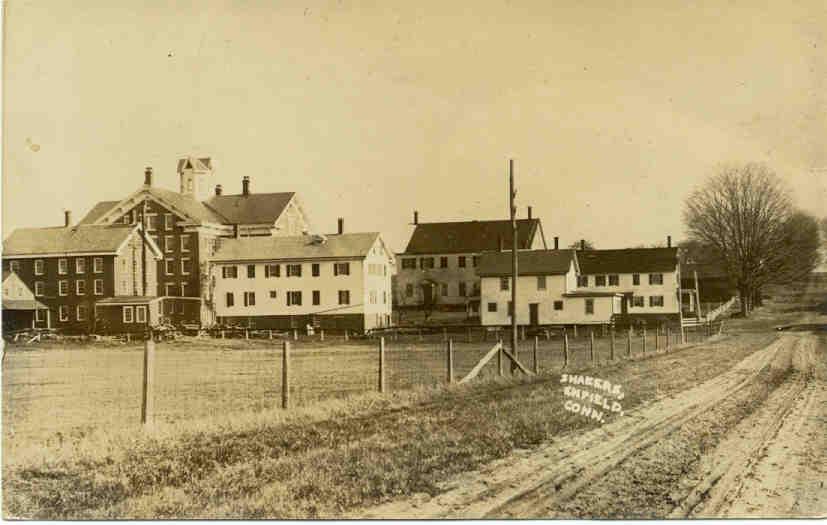
Enfield Shaker village
 Enfield (CT) Shaker Village c. 1910
In 1793, a historic Shaker village, one of nineteen scattered from Maine to Kentucky, was established in the town. The Utopian religious sect practiced celibate, communal living, and is today renowned for its simple architecture and furniture. Membership eventually dwindled, however, and the village disbanded. The property has since been redeveloped by the Enfield Correctional Institution, still located on "Shaker Road."
 Enfield (CT) Shaker Village
The presumption that Enfield was named for the Enfield area of London is incorrect. According to Dr. Frank Taylor, a noted historian of the town, Enfield was named, in a pattern similar to its neighboring towns of Springfield, Massachusetts (once Northfield) and Suffield, Connecticut (once Southfield). The neighborhood of Old Enfield in Austin, Texas is a namesake of Enfield, Connecticut, largely named by the family of Elisha M. Pease former governor of Texas who was born in Enfield, and whose great-great grandfather helped found Enfield as part of Massachusetts in the late 17th century.
Industry
Enfield was home to the U.S. headquarters of Danish plastic building toy manufacturer Lego, which was also the town's largest employer. In June 2006, the company announced that they would be laying off over 290 employees and begin outsourcing jobs to Mexico. Hallmark Cards is the town's second-largest employer.
Enfield was once the home to the headquarters of the Casual Corner clothing company.
Formerly and most notably, Enfield had booming carpet and gunpowder industries. Orrin Thompson set up shop for the Bigelow-Sanford Carpet Co. in the Thompsonville section of town, employing many Swedish immigrants and building housing for them, which still stand today.
The gunpowder industry was founded by Colonel Augustus Hazard. Hazard was instrumental in implementing water power and other technologies to allow his business to prosper. Hazard's company was among the biggest gunpowder suppliers for the American Civil War.
Enfield is currently the headquarters of Precision Camera and Video Repair.
The town contains several shopping centers, including the Enfield Square Mall. Neighboring shopping areas include The Shoppes at Buckland Hills in Manchester, Connecticut, the Holyoke Mall at Ingleside in Holyoke, Massachusetts, and Westfarms Mall in Farmington, Connecticut.
Neighborhoods
The neighborhoods of Enfield, Connecticut are as follows:
Enfield Historical District- Listed in the National Register of Historical Districts, the Enfield Historical District runs along Enfield Street/King Street (U.S. Route 5). Many old homes dating back to the mid-18th century were built from 1106-1492 Enfield Street. Varying styles of architecture are noted including Late Victorian, Georgian and 19th Century Revival. The Enfield Town Hall museum as well as one of the oldest Congregational Churches in America can be found here.
 Typical Enfield Neighborhood
Hazardville - Named after Colonel Augustus Hazard, this neighborhood encompasses a few smaller burbs, including Powder Hollow, and more recently, the center of Enfield began to encroach on this historical area. The center of Hazardville is located between the streets of Park Street and North Street on Hazard Avenue. Notable small shops include The Connecticut Valley Tobacconist, Gayle's Thyme Herbal Apothecary, The Cranberry Scoop Gift Shop, Smoke n' Leather, and numerous pizzarias. The Powder Hollow Park is located in the Hazardville neighborhood district.
North Thompsonville - Contains mostly residential and partially commercial areas of Enfield with many parks and schools.
Presidential Section - This entirely residential area contain streets that are all named after former Presidents of The United States of America. Houses are mid-sized to large in this area.
 Presidential Section
Scitico - Scitico is on the eastern end of town. Green Manor is considered part of Scitico. This is a suburb in the purest sense, with winding roads, sidewalks, a park, and cul-de-sacs. Green Manor is approximately 4.5 miles from the main highway Interstate 91 and borders Somers, Connecticut. Across from the elementary school Nathan Hale Elementary School is a residential park with tennis court, skate boarding ramps, and a playground for younger kids. Green Manor Park did contain a pool at one time but was removed due to the lack of maintenance by the town.
Shaker Pines - This Neighborhood consists mostly of tall pine trees towering above the quaint lakeside houses (hence the name). Shaker Pines was originally part of the Shaker settlement in Enfield. The lake was built by the Shakers to power a mill. The mill stood, vacant, at the dam located at the end of the lake into the late 1990s. This mill provided shelter for Frederick Merrill in 1987 after he escaped from the local high security prison. He was dubbed "The Peanut Butter Bandit" after his mother sneaked him supplies for his first prison escape in 1968 in a jar of peanut butter. The mill was subsequently torn down for safety reasons.
Sherwood Manor
 Thompsonville Village
Southwood Acres - A residential neighborhood in the south part of town.
Thompsonville - Named after Orrin Thompson, Thompsonville is the town center of Enfield with a more urban environment. In the past few years, there has been an attempt to revitalize the downtown area.[6] On the southbound portion of Pearl Street there are many old Victorians. There are also many boat launches onto the bordering Connecticut River. Commuter rail service is expected to begin in 2013, and planning has started for renovating an old building into a commuter rail station and transportation hub, on the proposed New Haven-Hartford-Springfield Line. Enfield and Thompsonville are currently served by the CT Transit commuter bus services for easy commuting to and from Hartford.
Parks and recreation
- Brainerd Park: on Brainard Road, features softball fields, children's swing sets. Note the difference in spelling.
- Connecticut River
- Green Manor Recreational Area: off Taylor Road, features playscape, skate park
- Hazardville Park: off Hazard Avenue, features playscapes, basketball courts, covered picnic area
- Mark Twain Recreational Area: off South Road, features tennis courts, ball fields
- Scantic River State Park: near South Maple Street Bridge, rapids for canoeing and kayaking, fishing
Enfield is also home of the New England Lightning girls AAU basketball program.
Government and infrastructure
Connecticut Department of Correction prisons are located in Enfield.[7] Enfield Correctional Institution,[8] Robinson Correctional Institution,[9] and Willard-Cybulski Correctional Institution are in Enfield.[10]
Education
Asnuntuck Community College is a two-year college in Enfield.[11]
Enfield Public Schools operates the town's public schools.
Enfield High School and Enrico Fermi High School are the district's high schools. John F. Kennedy Middle School is the town's middle school. There are nine elementary schools in the district. The Enfield Elementary School System runs from kindergarten through grade 6, the Enfield School Junior High School runs from grade 7 through grade 8, and the Senior High Schools run from grade 9 through grade 12.
Thomas G. Alcorn School was originally a high school until it was converted to an elementary school when the current high school (Enfield High School) was built. It was later extensively renovated in 1993. As of 2005, Enfield Public Schools manages approximately 3,500 students.
Capitol Region Education Council has its own magnet school in Enfield. The Public Safety Academy ranges from grade 6 through 12
There is also a presence of parochial schools in Enfield. Three Catholic schools, grades K-8, serve the Enfield community. Typically, these schools operate on the same academic calendar as the public schools.
Notable residents, past and present
- Jeremiah Mervin Allen, (1833–1903), born in Enfield, noted educator, engineer, and president of the YMCA.[12]
- Johnny April, bassist for the alternative metal/hard rock band Staind.
- John Ashton, actor, attended Enfield High School (former resident).
- Elijah Churchill, soldier in the American Revolutionary War and recipient of the medal later known as the Purple Heart.
- Kevin Foxe, Film Producer, Writer, Executive Producer of The Blair Witch Project was born and grew up in Enfield, graduated Enfield High School. [1]
- Paul Herscu, naturopathic doctor noted for his homeopathic work. (www.nhcmed.com)
- Craig Janney, Olympian and professional ice hockey center (former resident).
- Peter King, football columnist for Sports Illustrated and author.
- Elisha M. Pease, politician and two-term Governor of Texas (elected in 1853 and 1855). Renamed 15th Street in Austin, Texas Enfield Road after the town where he was born.[13]
- Paul Robeson, singer and actor (former resident).
- Karen Scavotto, Olympic archer.
- Bill Spanswick, baseball pitcher for the Boston Red Sox.[14]
- Nathaniel Terry, Representative from Connecticut in the 15th United States Congress (served 1817-1819).
- The Last Goodnight, Upcoming band originally from Enfield and formerly called Renata, attended Enfield High School.
Notable historical sites
- The Strand Theatre: (a.k.a. Enfield Cinema) Most prominently active in the '40s and '50s, in the '70s the Strand had to resort to X-rated films to remain afloat until finally closing doors in the 1980s. Locals have many ideas for the future of the theater, but it is in great disrepair.
- Bigelow-Sanford Carpet Co.: Now Bigelow Commons, a renovated upscale condominium complex, these buildings were the site of a large carpet company that employed many in the town. Listed in the National Register of Historic Places.
Sister cities
Enfield has two official sister cities as designated by Sister Cities International [2]:
 Jhongli City, Taiwan (Republic of China).
 Ronneby, Sweden.
See also
References
- ^ "Public Act No. 09-203", State of Connecticut, July 7, 2009, As Retrieved 2010-03-12
- ^ a b "The Adventists at Terry Island", The New York Times, November 28, 1873, As Retrieved 2010-03-12
- ^ "American FactFinder". United States Census Bureau. http://factfinder.census.gov. Retrieved 2008-01-31.
- ^ "Registration and Party Enrollment Statistics as of October 25, 2005" (PDF). Connecticut Secretary of State. Archived from the original on 2006-09-23. http://web.archive.org/web/20060923151511/http://www.sots.ct.gov/ElectionsServices/lists/2005OctRegEnrollStats.pdf. Retrieved 2006-10-02.
- ^ a b Bob Clark (18 December 2006). Enfield Connecticut: Stories Carved in Stone. Dog Pond Press. pp. 14–15. ISBN 9780975536254. http://books.google.com/books?id=ZKAm2Eu8mJYC&pg=PA5. Retrieved 22 September 2010.
- ^ Lightman, David and Larry Smith (2007-04-14). "Constituents Make A Pitch". The Hartford Courant. http://www.courant.com/news/politics/hc-dclobbyists0414.artapr14,0,732726.story?coll=hc-big-headlines-breaking. Retrieved 2007-04-21.
- ^ "Zoning Map." Enfield, Connecticut. Retrieved on August 16, 2010.
- ^ "Enfield Correctional Institution." Connecticut Department of Correction. Retrieved on August 16, 2010.
- ^ "Robinson Correctional Institution." Connecticut Department of Correction. Retrieved on August 16, 2010.
- ^ "Willard-Cybulski Correctional Institution." Connecticut Department of Correction. Retrieved on August 16, 2010.
- ^ "Welcome." Asnuntuck Community College. Retrieved on August 16, 2010.
- ^ Who Was Who in America, Historical Volume, 1607-1896. Chicago: Marquis Who's Who. 1963.
- ^ "Austin Streets: Street Name Origins." Retrieved on May 10, 2011.
- ^ http://marian.creighton.edu/~besser/baseball/nsl1958.html
External links
- Town of Enfield, Connecticut Official website
- Enfield Historical Society
- Enfield Public Schools Official website
- Enfield School District Information
- National Register of Historical Districts, Hartford County, Connecticut
- Central Regional Tourism District
- Enfield CT Photographic Tour and History
- Enfield News from Hartford Courant
- Hartford Courant: Enfield iTowns Blog
- Journal Inquirer: Enfield news
- Enfield's Business Listings and Town Crier
 State of Connecticut
Topics - Index
- Culture
- Constitution
- Delegations
- Elections
- Geography
- Government
- History
- Images
- People
- Visitor Attractions
Regions Counties Cities Places Municipalities and communities of Hartford County, Connecticut Cities 
Towns Avon | Berlin | Bloomfield | Burlington | Canton | East Granby | East Hartford | East Windsor | Enfield | Farmington | Glastonbury | Granby | Hartland | Manchester | Marlborough | Newington | Plainville | Rocky Hill | Simsbury | South Windsor | Southington | Suffield | West Hartford | Wethersfield | Windsor Locks | Windsor
Unincorporated
communitiesBlue Hills | Broad Brook | Burnside | Collinsville | Hazardville | Hockanum | Kensington | Marion | Milldale | Newington Junction | North Granby | Plantsville | Sherwood Manor | Simsbury Center | Southwood Acres | Tariffville | Terramuggus | Thompsonville | Weatogue | West Simsbury
Categories:- Enfield, Connecticut
- Towns in Hartford County, Connecticut
- Utopian communities
- Populated places on the Connecticut River
- Populated places established in 1679


Wikimedia Foundation. 2010.