- Cupertino, California
-
"Cupertino" redirects here. For the word-processing phenomenon, see Cupertino effect.
Cupertino — City — City of Cupertino 
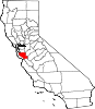
SealLocation in Santa Clara County and the state of California Location within the United States
 Cupertino
Coordinates: 37°19′3″N 122°2′31″W / 37.3175°N 122.04194°WCoordinates: 37°19′3″N 122°2′31″W / 37.3175°N 122.04194°W Country  United States
State  California
County Santa Clara Incorporated October 10, 1955 Government - Type Mayor-council - Body Cupertino City Council - Mayor Gilbert Wong - Vice-Mayor Mark Santoro - Councillors ListArea[2] - Total 11.257 sq mi (29.156 km2) - Land 11.256 sq mi (29.153 km2) - Water 0.001 sq mi (0.003 km2) 0.01% Elevation 236 ft (72 m) Population (2010) - Total 58,302 - Density 5,179.2/sq mi (1,999.7/km2) Time zone PST (UTC-8) - Summer (DST) PDT (UTC-7) ZIP codes 95014-95015 Area code(s) 408 FIPS code 06-17610 GNIS feature ID 0277496 Website cupertino.org Cupertino (
 /ˌkuːpərˈtiːnoʊ/) is an affluent suburban city in Santa Clara County, California in the U.S., directly west of San Jose on the western edge of the Santa Clara Valley with portions extending into the foothills of the Santa Cruz Mountains. The population was 58,302 at the time of the 2010 census.[3] Forbes ranked it as one of the most educated small towns. It is best known as home to the worldwide headquarters of Apple Inc.
Contents
Toponym
Cupertino was named after Arroyo San José de Cupertino (now Stevens Creek). The creek had been named by Spanish explorer Juan Bautista de Anza's cartographer, who named it after Saint Joseph of Cupertino. Saint Joseph (born Giuseppe Maria Desa, and later known as Giuseppe da Copertino) was named after the town of Copertino in the Apulia region of Italy. The name Cupertino first became widely used when John T. Doyle, a San Francisco lawyer and historian, named his winery on McClellan Road "Cupertino". After the turn of the 20th century, Cupertino displaced the former name for the region, which was "West Side". Recently it tied up with Bhubaneswar in India as a sister city for mutual and co-lateral growth.
History
Cupertino in the 19th century was a small rural village at the crossroads of Stevens Creek Road and Saratoga-Mountain View Road (also known locally as Highway 9; later Saratoga-Sunnyvale Road, and then renamed to De Anza Boulevard within Cupertino city limits). Back then, it was known as the West Side and was part of Fremont Township. The primary economic activity was fruit agriculture. Almost all of the land within Cupertino's present-day boundaries was covered by prune, plum, apricot, and cherry orchards. A winery on Montebello Ridge overlooking the Cupertino valley region was also operating by the late 19th century.
Soon railroads, electric railways, and dirt roads traversed the West Side farmlands. Monta Vista, Cupertino's first housing tract, was developed in the mid-20th century as a result of the electric railway's construction.
After World War II, a population and suburban housing boom dramatically shifted the demographics and economy of the Santa Clara Valley, as the "Valley of Heart's Delight" was beginning to transform into "Silicon Valley". In 1954, Cupertino leaders began to drive for incorporation as they were concerned about unplanned development and rising property taxes. In the September 27, 1955 election, voters approved the incorporation of the City of Cupertino. Cupertino officially became Santa Clara County's 13th City on October 10, 1955.
A major milestone in Cupertino's development was the creation by some of the city's largest landowners of VALLCO Business and Industrial Park in the early 1960s. Of the 25 property owners, 17 decided to pool their land to form VALLCO Park, 6 sold to Varian Associates (property later sold to Hewlett-Packard), and two opted for transplanting to farms elsewhere. The name VALLCO was derived from the names of the principal developers: Varian Associates and the Leonard, Lester, Craft, and Orlando families. A neighborhood outdoor shopping center and, much later, the enclosed Vallco Fashion Park, briefly renamed Cupertino Square, were also developed.
De Anza College opened in 1967. The college, named for Juan Bautista De Anza, occupies a 112-acre (0.45 km2) site that was the location of a winery built at the turn of the last century, called Beaulieu by its owners, Charles and Ella Baldwin. Their mansion has now become the California History Center. De Anza College now has about 22,000 students and is a hub of activity in the city. Its flea market, held the first Saturday of the month, attracts thousands from around the area.
Housing developments were rapidly constructed in the following years as developers created many neighborhoods, including Fairgrove, Garden Gate, Monta Vista, Seven Springs, and many other developments. Although originally low-cost housing, Silicon Valley's housing prices shot up dramatically as many houses that were formerly lowly priced became multi-million dollar homes. The high cost of living in Cupertino is attributed by people wanting their children to receive high-quality schooling. Nevertheless, the price of housing seems to have weathered even the 2007–8 slump in economy.
On December 1, 2009, Cupertino became the first city in Northern California to have an Asian-American-majority city council.
Demographics
2010
The 2010 United States Census[4] reported that Cupertino had a population of 58,302. The population density was 5,179.1 people per square mile (1,999.7/km²). The racial makeup of Cupertino was 18,270 (31.3%) White, 344 (0.6%) Black American, 117 (0.2%) American Indian, 36,895 (63.3%) Asian (28.1% Chinese, 22.6% Indian, 4.6% Korean, 3.3% Japanese, 1.3% Vietnamese, 0.9% Filipino, 0.4% Pakistani, 0.1% Thai, 0.1% Bangladeshi), 54 (0.1%) Pacific Islander, 670 (1.1%) from other races, and 1,952 (3.3%) from two or more races. Hispanic or Latino of any race were 2,113 persons (3.6%); 2.4% of Cupertino is Mexican.
The Census reported that 57,965 people (99.4% of the population) lived in households, 61 (0.1%) lived in non-institutionalized group quarters, and 276 (0.5%) were institutionalized.
There were 20,181 households, out of which 9,539 (47.3%) had children under the age of 18 living in them, 13,802 (68.4%) were opposite-sex married couples living together, 1,393 (6.9%) had a female householder with no husband present, 581 (2.9%) had a male householder with no wife present. There were 378 (1.9%) unmarried opposite-sex partnerships, and 89 (0.4%) same-sex married couples or partnerships. 3,544 households (17.6%) were made up of individuals and 1,612 (8.0%) had someone living alone who was 65 years of age or older. The average household size was 2.87. There were 15,776 families (78.2% of all households); the average family size was 3.28.
The population was spread out with 16,075 people (27.6%) under the age of 18, 3,281 people (5.6%) aged 18 to 24, 15,621 people (26.8%) aged 25 to 44, 16,044 people (27.5%) aged 45 to 64, and 7,281 people (12.5%) who were 65 years of age or older. The median age was 39.9 years. For every 100 females there were 97.4 males. For every 100 females age 18 and over, there were 94.6 males.
There were 21,027 housing units at an average density of 1,867.9 per square mile (721.2/km²), of which 12,627 (62.6%) were owner-occupied, and 7,554 (37.4%) were occupied by renters. The homeowner vacancy rate was 0.8%; the rental vacancy rate was 4.7%. 36,464 people (62.5% of the population) lived in owner-occupied housing units and 21,501 people (36.9%) lived in rental housing units.
2005
According to the 2005-2007 American Community Survey of the US Census Bureau, the median income for a household in the city was $118,635, and the median income for a family was $140,199. The per capita income for the city was $44,774. About 3.6% of families and 5.2% of the population were below the poverty line, including 3.9% of those under age 18 and 8.1% of those age 65 or over.[5]
According to the 2005-2007 American Community Survey, White Americans made up 37.4% of Cupertino's population. Black Americans now made up 1.5% of Cupertino's population and American Indians made up 0.4% of the city's population. In addition, Cupertino now has an Asian American majority as this group now represents 55.7% of the city's population. Pacific Islander Americans remained at 0.1% of the population. Also, 2.5% of the population are from some other race and 2.4% of the population are from two or more races. Hispanics or Latinos remained at 4.0% of Cupertino's population.[6] In the 2000 Census, non-Hispanic whites made up 47.8% of Cupertino's population.[7] According to the 2005-2007 American Community Survey, non-Hispanic whites now represented 35.3% of the city's population.[8]
Cupertino was the only city with both a population over 50,000 and a median household income in excess of $100,000 in 2000 besides Naperville, Illinois.
Geography
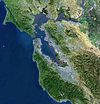
Cupertino is located at 37°19′3″N 122°2′31″W / 37.3175°N 122.04194°W (37.317492, −122.041949),[9] at the southern end of the San Francisco Bay. The eastern part of the city, located in the Santa Clara Valley, is flat while the western part of the city slopes into the Santa Cruz Mountains.
According to the United States Census Bureau, the city has a total area of 11.3 square miles (29 km2),[9] 99.99% of it land and 0.01% of it water.
Cupertino has warm weather with mild, wet winters and hot, dry summers. Oak and redwood forests cover the hills overlooking the Cupertino lowlands.
Averages in July (at Santa Clara University)
- Maximum 82.0 °F (27.8 °C)
- Minimum 54.1 °F (12.3 °C)
Averages in January (at Santa Clara University)
- Maximum 58.2 °F (14.6 °C)
- Minimum 38.7 °F (3.7 °C)
Extremes
- High 114 °F (46 °C) - June 1961
- Low 16 °F (−9 °C) - December 1990
Neighborhoods
Cupertino is made up of numerous subdivisions, most of them developed since the 1960s. Two of the newest parts of Cupertino are actually among its oldest housing tracts. Monta Vista and Rancho Rinconada were developed outside of the city's boundaries in the 1950s and before. Rancho Rinconada was annexed in 1999[10] and the last part of Monta Vista was annexed in 2004.[11] The neighborhood of Seven Springs is at the Southern tip of Cupertino and was developed in the 1980s. The newest and most northern neighborhood, Oak Valley, borders Rancho San Antonio Park and was developed around the year 2000.
Layout

Cali Mill Plaza marks the traditional center of the city and the historical location of Crossroads. However, Cupertino does not have a traditional downtown shopping and commercial district.
Economy
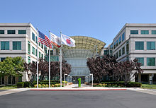
Cupertino is one of many cities that claim to be the "heart" of Silicon Valley, as many semi-conductor and computer companies were founded here and in the surrounding areas. The worldwide headquarters for Apple Inc. is also located here in a modern complex circled by the playfully named Infinite Loop. Apple has also announced that it plans to build a new 150-acre (610,000 m2) second campus between Interstate 280, N Wolfe Rd, E Homestead Rd and along Tantau Ave one mile east of the old campus. The different (nine) properties (50-acre (0.2 km2) south of Pruneridge Avenue were bought in 2006, the property (100-acre (0.4 km2) north of it in 2010 (from Hewlett-Packard). On June 7, 2011, a few months before his October 5 death from pancreatic cancer, Steve Jobs gave a presentation to Cupertino City Council, detailing the architectural design of the new building and its environs.[12] The new campus is planned to house up to 13,000 employees in one central four-storied circular building surrounded by extensive landscape (with parking mainly underground and the rest centralized in a parking structure).
Other companies headquartered in Cupertino include Trend Micro, Cloud.com, Lab126, Packeteer, Chordiant, and Portal Software. Over 60 high-tech companies have offices there, including IBM, Olivetti and Oracle. Most of these high-tech companies are located on De Anza Boulevard, Cali Mill Plaza, and Bubb Road.
Though Cupertino is home to the headquarters of many high-tech companies, very little manufacturing actually takes place in the city. The city's large office parks are primarily dedicated to management and design functions.
 Winter morning at the farmers' market at Vallco Shopping Mall
Earlier in its history Cupertino attributed some of its city income from Vallco Fashion Park (see above), at the time one of the only major indoor shopping malls in the South Bay area. People from the greater South Bay area would come to spend money and contribute to the sales tax. Since then, several other shopping malls have sprung up; Valley Fair (now known as Westfield Valley Fair) in Santa Clara caters to the high end, expensive name brand boutique stores, while the Great Mall in Milpitas in the 1990s opened to the low-priced and bargain retailers. Vallco Fashion Park was hit hard by these developments, as well as the loss of one of its anchor stores, Emporium, and has had a hard time recovering ever since.
In 2002, Cupertino had a labor force of 25,780 with an unemployment rate of 4.5%. The unemployment rate for the Santa Clara County as a whole was 8.4%.
One of the major employers in the area is the aggregate rock quarry and cement plant in the foothills to the west of Cupertino. Currently owned and operated by Lehigh Southwest Cement, it was originally founded by Henry J. Kaiser as the Kaiser Permanente Cement Plant in 1939. Its somewhat novel charter was to provide the majority of the cement used in the construction of the Shasta Dam. It achieved this goal to with impressive results, supplying the 6 million barrels (950,000 m3) of cement over a dedicated nine mile (14 km)-long conveyor system.[13] The cement plant continues to be an important part of the local economy, and is the sole reason for the lone railroad line that runs through the city. Lehigh Permanente Cement was honored as the Large Business of the Year by the Cupertino Chamber of Commerce in 2001-2002. On October 5, 2011, the Lehigh Permanente Cement Plant was the site of a shooting in which a disgruntled employee named Shareef Allman shot and killed three people and wounded seven, including one person who was injured during the course of a carjacking by Allman after the shooting. Allman was shot dead by three deputies, two men and one woman (each with less than five years' time at the department), after he would not surrender and displayed a firearm in a threatening manner toward the deputies.[14][15]
Top employers
According to the City's 2010 Comprehensive Annual Financial Report,[16] the top employers in the city are:
# Employer # of Employees 1 Apple 34,300 (in area) 2 Oracle 8,000 (in area) 3 Foothill-De Anza Community College District 3,100 4 Hewlett-Packard 3,000 5 Cupertino Union School District 1,679 6 ArcSight 512 7 Fremont Union High School District 429 8 Chordiant 285 9 The Forum at Rancho San Antonio 285 10 Trend Micro 250 Law and government
Local
 The city seal of Cupertino from 1999 to 2007.
Cupertino was incorporated in 1955. The highest body in the city government is the City Council, made up of five members who serve overlapping, four-year terms. The council itself elects the mayor and vice-mayor for a term of one year. The city does not have its own charter. Instead, it is a General Law city, which follows provisions and requirements for cities established by the state of California.
Cupertino contracts with the Santa Clara County Sheriff's Office and the Santa Clara County Fire Department for public safety services. The Cupertino Library is part of the Santa Clara County Library System.
The city's symbol is a conquistador's morion. A sculpture of this helmet stands next to Cupertino City Hall, and several versions of the helmet have also been used as the city logo. The original sculpture was made in 1971 by John Augsburger of San Luis Obispo. A full-sized replica of the sculpture, made by Fred Subega was given to the city of Toyokawa, Japan as a gift to commemorate their tenth anniversary as sister cities. A smaller sculpture in the shape of the helmet in the 1999-2007 Cupertino city seal was also given to the city of Toyokawa as a twenty-fifth anniversary present.
State and federal
In the state legislature Cupertino is located in the 11th Senate District, represented by Democrat Joe Simitian, and in the 22nd Assembly District, represented by Democrat Paul Fong. Federally, Cupertino is located in California's 15th congressional district, which has a Cook PVI of D+14[17] and is represented by Democrat Mike Honda.
Transportation
The city is served by an interconnected road system. Two freeways, State Route 85 and Interstate 280, intersect in Cupertino, and like any typical middle-class California suburb, it also has multi-lane boulevards with landscaped medians and traffic lights at all major intersections. Streets are in good condition and nearly all have sidewalks. The few exceptions are in unincorporated pockets at the city's edges, which are maintained directly by Santa Clara County.
Gridlock traffic occurs at some main intersections during evening rush hour (5 p.m. to 7 p.m.), particularly at De Anza Boulevard and Interstate 280 because of freeway metering lights.
Cupertino has bike lanes on many of its boulevards, though due to the high volume of traffic bicyclists must exercise caution. Bicycle traffic is heavy usually around morning and noon times around DeAnza college, helmets are compulsory for cyclists below the age of eighteen, but are always recommended. Patrol cars will not stop juvenile riders not wearing a helmet, but patrol cars will not hesitate to stop and warn bicyclists not following the Cupertino Bicycle laws. The VTA has several buses running through Cupertino at major arteries, and all buses have bike racks that can support up to two bikes. If there are already two bikes on the rack, it is up to the bus driver to decided whether the passenger can bring the bike aboard or not - usually the passenger is not allowed to if the bus is already full. Blinkers and safety reflectors are mandatory and recommended for night time riding, Cupertino's main streets are well lit, while a few older roads towards the Monta Vista High School area are a little dim requiring a higher level of awareness for bicyclists during night times.
Dedicated on April 30, 2009, Cupertino opened the Mary Avenue Bicycle Footbridge, the first cable-stay bicycle pedestrian bridge over a California freeway. This bridge connects the north and the south sections of the Stevens Creek Trail. The total cost of the bridge project was $14,800,000.[18]
The Union Pacific Railroad operates a branch line track up to the Lehigh Permanente Cement Plant from the mainline at San Jose Diridon Station. It is however strictly for the quarry and very little to no non-quarry traffic runs there.
There is no commuter rail or light rail service in the city. Caltrain commuter rail runs through the cities to the north and east, and the Santa Clara Valley Transportation Authority (VTA)'s Mountain View - Winchester light rail line runs to Campbell, California to the south. Bus service is also provided by VTA, and the prospect of twenty-four hour bus service on Stevens Creek Boulevard is being studied. Though this corridor (line 23) is one of VTA's most heavily used routes, there is no express or limited-stop service that takes commuters into San Jose, and the quality of service is therefore considered to be relatively poor. Better service would most likely not be economical[citation needed] because the population density of the area is relatively low due to the trend of the area toward independent houses and very small apartment blocks.
Cupertino is landlocked and, like most Bay Area cities, relies on the Port of Oakland for most oceangoing freight.
Passenger and cargo air transportation is available at San Jose International Airport in San Jose. The closest general aviation airport is in Palo Alto; it is known as Palo Alto Airport of Santa Clara County.
In addition, China Airlines operates bus services from Marina Food at 10122 Bandley Drive in Cupertino to San Francisco International Airport to feed its flight to Taipei, Taiwan.[19]
Education
Primary and secondary
Main articles: Cupertino Union School District and Fremont Union High School DistrictCupertino Schools*
- Not all schools are in Cupertino
- CUSD = Cupertino Union School District
- FUHSD = Fremont Union High School District
- LS = Lottery School
- Bold = Primary Path
- -Italic- = Secondary Path
- -Bold Italic- = Both Primary and Secondary
Elementary School (CUSD) 2011 API Score Murdock-Portal 998 William Faria 998 Nelson S. Dilworth 991 L. P. Collins 983 Abraham Lincoln 981 William Regnart 976 Blue Hills 975 R. I. Meyerholz 969 Louis E. Stocklmeir 966 Stevens Creek 960 C. B. Eaton 959 Montclaire 958 West Valley 957 John Muir 944 D. J. Sedgwick 936 Dwight D. Eisenhower 931 Manuel De Vargas 883 Chester W. Nimitz 866 Middle School (CUSD) 2011 API Score John F. Kennedy 983 Sam H. Lawson 983 Joaquin Miller 981 Cupertino 935 Warren E. Hyde 858 High School (FUHSD) 2011 API Score Monta Vista 949 Lynbrook 943 Cupertino 893 Homestead 866 Fremont 767 Cupertino is very well known for its high achieving primary and secondary schools. For example, Murdock-Portal Elementary and Faria Elementary School are tied for highest score for elementary public school in the state of California, per California 2011 API test scores. Kennedy Middle School is the third best in the state. Furthermore, Monta Vista High School is ranked number 23 out of all the public schools in the nation.
Primary (K-8) public schools are organized into the Cupertino Union School District, while the Fremont Union High School District is responsible for high school students. Cupertino High School and its feeder school, Hyde Middle School, are located in the Rancho Rinconada section of Cupertino, while Monta Vista High School and its feeder, Kennedy Middle School, are in the Monta Vista neighborhood in the western half of Cupertino. There is also a new school called Lawson Middle School that feeds mostly Cupertino and Monta Vista High. In addition, Homestead High School is located in the northwestern portion of Cupertino, along the city border with neighboring Sunnyvale. The school system covers Cupertino plus some southern areas of Sunnyvale and Los Altos and some western areas of San Jose.
Colleges and universities
Cupertino is home to De Anza College, one of the two community colleges in the Foothill-De Anza Community College District. De Anza runs a facility called Flint Center, a large enclosed theater which is the primary venue for performing arts in the West Valley, which is widely used as a music hall by various symphonies, such as the California Youth Symphony and the San Francisco Symphony.
The University of California, Santa Cruz (Extension) and the University of San Francisco (a private Catholic university) have satellite campuses in Cupertino.
San Jose State University, Santa Clara University, and Stanford University, are also close by. The main UC Santa Cruz campus is about 45 minutes away via Highway 17.
Public libraries
Santa Clara County Library operates the Cupertino Library.[20] The library is the busiest branch in the Santa Clara County Library system, with about 3 million items circulated annually.[21]
Places of interest
Vallco Mall, at the center of Cupertino, includes department stores (Macy's, JCPenney, Sears, etc.), an ice center, bowling, and an AMC theater complex. It hosts a farmer's market on Fridays. The scenic Blackberry Farm golf course and ranch is located near Monta Vista High School. The Cupertino Historical Society has an elaborate museum at the Cupertino Community Center, located next to Memorial Park, which houses the Cupertino Veterans Memorial as well as an amphitheater that hosts events such as summer movies and Free Shakespeare in the Park.
Notable residents (or former residents)
- Adyashanti - spiritual teacher
- Matthew Axelson - Navy SEAL who died in battle in Afghanistan and awarded the Navy Cross
- Aaron Eckhart - actor
- Steve Jobs - co-founder of Apple Inc.
- David Kramer - Professional soccer player
- Ronnie Lott- Former defensive player for the San Francisco 49ers and Oakland Raiders
- Bryan Mantia - drummer for Primus and Guns N' Roses
- Daniel Puder - Mixed Martial Arts fighter/former WWE wrestler
- Steve Wozniak - co-founder of Apple Inc.
Sister cities
 Copertino, Apulia, Italy
 Hsinchu, Republic of China (Taiwan)
 Toyokawa, Japan
 Bhubaneswar, Orissa, India
References
- ^ http://www.cupertino.org/index.aspx?page=991
- ^ U.S. Census
- ^ US Census 2000 Data for Cupertino, CAcensus.gov, Retrieved July 10, 2007
- ^ All data are derived from the United States Census Bureau reports from the 2010 United States Census, and are accessible on-line here. The data on unmarried partnerships and same-sex married couples are from the Census report DEC_10_SF1_PCT15. All other housing and population data are from Census report DEC_10_DP_DPDP1. Both reports are viewable online or downloadable in a zip file containing a comma-delimited data file. The area data, from which densities are calculated, are available on-line here. Percentage totals may not add to 100% due to rounding. The Census Bureau defines families as a household containing one or more people related to the householder by birth, opposite-sex marriage, or adoption. People living in group quarters are tabulated by the Census Bureau as neither owners nor renters. For further details, see the text files accompanying the data files containing the Census reports mentioned above.
- ^ http://factfinder.census.gov/servlet/ADPTable?_bm=y&-geo_id=16000US0617610&-qr_name=ACS_2007_3YR_G00_DP3YR3&-ds_name=ACS_2007_3YR_G00_&-_lang=en&-redoLog=false&-_sse=on
- ^ http://factfinder.census.gov/servlet/ACSSAFFFacts?_event=Search&geo_id=&_geoContext=&_street=&_county=Cupertino&_cityTown=Cupertino&_state=&_zip=&_lang=en&_sse=on&pctxt=fph&pgsl=010
- ^ http://factfinder.census.gov/servlet/QTTable?_bm=y&-geo_id=16000US0617610&-qr_name=DEC_2000_SF1_U_DP1&-ds_name=DEC_2000_SF1_U&-_lang=en&-redoLog=false&-_sse=on
- ^ http://factfinder.census.gov/servlet/ADPTable?_bm=y&-geo_id=16000US0617610&-qr_name=ACS_2007_3YR_G00_DP3YR5&-ds_name=ACS_2007_3YR_G00_&-_lang=en&-redoLog=false&-_sse=on
- ^ a b "US Gazetteer files: 2010, 2000, and 1990". United States Census Bureau. 2011-02-12. http://www.census.gov/geo/www/gazetteer/gazette.html. Retrieved 2011-04-23.
- ^ Rancho annexation complete, Cupertino Courier, March 10, 1999
- ^ On March 4 Monta Vista annexed if not appealed Cupertino Courier, February 25, 2004
- ^ Steve Jobs Presents to Cupertino City Council
- ^ Shasta Dam - Encyclopedia Britannica
- ^ Prodis Sulek, Julia (5 October 2011). "Cupertino quarry shooting suspect who killed 3, wounded 7 still on loose". San Jose Mercury News. http://www.mercurynews.com/top-stories/ci_19046357. Retrieved 5 October 2011.
- ^ http://www.huffingtonpost.com/2011/10/06/shareef-allman-shot_n_998231.html
- ^ City of Cupertino CAFR
- ^ "Will Gerrymandered Districts Stem the Wave of Voter Unrest?". Campaign Legal Center Blog. http://www.clcblog.org/blog_item-85.html. Retrieved 2008-02-10.
- ^ "Mary Avenue Bicycle Footbridge Dedication,"City of Cupertino
- ^ "South Bay- SFO Int'l Airport Bus Service," China Airlines
- ^ "Welcome to the Cupertino Library." Santa Clara County Library. Retrieved on March 27, 2010.
- ^ "Community known for being 'hooked on books' gets a new librarian"
External links
- Official website
- Cupertino Courier
- Cupertino Union School District
- Cupertino's name and history (PDF)
- Fremont Union High School District official site
- Cupertino Veterans Memorial Park
San Jose and Silicon Valley attractions Arboreta/Gardens Cultural American Musical Theatre of SJ · Ballet San Jose · Cathedral Basilica of St. Joseph · Choral Project · De Saisset Museum · Dr. Martin Luther King, Jr. Library · Gurdwara Sahib · Ira F. Brilliant Center for Beethoven Studies · Mexican Heritage Plaza · Opera San Jose · SJ City Hall · SJ Flea Market · SJ Improv · SJ Museum of Art · SJ Rep Theatre · Viet Museum · Villa Montalvo · Vivace Youth ChorusEvent venues Events BayCon · Cinequest Film Festival · FanimeCon · FurCon · LiveStrong Challenge · SJ Holiday Parade · SJ Jazz Festival · Stanford Jazz FestivalHistorical Parks/Trails Almaden Quicksilver County Park · Alum Rock Park · Bay Area Ridge Trail · Castle Rock State Park · Ed Levin Park · Grant Ranch Park · Guadalupe River Trail · Kelley Park · Lake Cunningham · Los Alamitos Creek Trail · Los Gatos Creek Trail · Plaza de César Chávez · Rancho San Antonio · Rosicrucian Park · Sanborn Park · SF Bay Trail · Shoreline Park · Stevens Creek Trail · Vasona ParkScience/Tech/Education Shopping Eastridge · Great Mall · Oakridge · PruneYard · San Antonio · Santana Row · Stanford · Vallco · Valley Fair · WestgateTheme parks & Tours Airship Ventures · Billy Jones Wildcat Railroad · Great America · Gilroy Gardens · Happy Hollow Park & Zoo · Raging WatersVineyards/Wineries San Francisco Bay Area Bodies of water Bodega Bay · Carquinez Strait · Clifton Forebay · Golden Gate · Grizzly Bay · Guadalupe River · Half Moon Bay · Lake Berryessa · Napa River · Oakland Estuary · Petaluma River · Richardson Bay · Richmond Inner Harbor · Russian River · San Francisco Bay · San Leandro Bay · San Pablo Bay · Sonoma Creek · Suisun Bay · Tomales Bay
Counties Alameda · Contra Costa · Marin · Napa · San Francisco · San Mateo · Santa Clara · Solano · Sonoma
Major cities Cities and towns
100k–250kCities and towns
25k–99kAlameda · Belmont · Benicia · Brentwood · Burlingame · Campbell · Castro Valley · Cupertino · Danville · Dublin · East Palo Alto · Foster City · Gilroy · Livermore · Los Altos · Los Gatos · Martinez · Menlo Park · Milpitas · Morgan Hill · Mountain View · Napa · Newark · Novato · Oakley · Pacifica · Palo Alto · Petaluma · Pittsburg · Pleasant Hill · Pleasanton · Redwood City · Rohnert Park · San Bruno · San Carlos · San Leandro · San Mateo · San Pablo · San Rafael · San Ramon · Saratoga · South San Francisco · Suisun City · Union City · Vacaville · Walnut Creek · Windsor
Cities and towns
5k–25kAlamo · Albany · Alum Rock · American Canyon · Ashland · Atherton · Bay Point · Blackhawk-Camino Tassajara · Cherryland · Clayton · Discovery Bay · Dixon · El Cerrito · El Sobrante · Emeryville · Fairview · Half Moon Bay · Healdsburg · Hercules · Hillsborough · Lafayette · Larkspur · Los Altos Hills · Millbrae · Mill Valley · Moraga · North Fair Oaks · Orinda · Piedmont · Pinole · San Anselmo · San Lorenzo · Sonoma · Stanford · Tamalpais-Homestead Valley
Sub-regions Municipalities and communities of Santa Clara County, California County seat: San Jose Cities and towns Campbell | Cupertino | Gilroy | Los Altos | Los Altos Hills | Los Gatos | Milpitas | Monte Sereno | Morgan Hill | Mountain View | Palo Alto | San Jose | Santa Clara | Saratoga | Sunnyvale
CDPs Alum Rock | Burbank | Cambrian Park | East Foothills | Fruitdale | Lexington Hills | Loyola | San Martin | Stanford
Unincorporated
communitiesBell Station | Casa Loma | Chemeketa Park | Coyote | Holy City | Loma Chiquita | Old Gilroy | New Almaden | Redwood Estates | Rucker | San Antonio Valley | Sargent | Sveadal
Ghost towns Categories:- Silicon Valley
- Cupertino, California
- Cities in Santa Clara County, California
- Cities in the San Francisco Bay Area
- 1955 establishments
- Incorporated cities and towns in California
- Populated places in the United States with Asian American majority populations


Wikimedia Foundation. 2010.