- Wick, Highland
-
Coordinates: 58°27′14″N 3°05′20″W / 58.454°N 3.089°W
Wick Scottish Gaelic: Inbhir Ùige Scots: Week 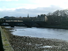
Looking down-river towards the Bridge of Wick
 Wick
Wick
Wick shown within the Highland council areaPopulation 7,333 Census 2001 OS grid reference ND365505 - Edinburgh 256 miles (412 km) - London 631 miles (1016 km) Council area Highland Lieutenancy area Caithness Country Scotland Sovereign state United Kingdom Post town WICK Postcode district KW1 Dialling code 01955 Police Northern Fire Highlands and Islands Ambulance Scottish EU Parliament Scotland UK Parliament Caithness, Sutherland and Easter Ross Scottish Parliament Caithness, Sutherland and Ross List of places: UK • Scotland • Wick (Scottish Gaelic: Inbhir Ùige) is an estuary town and a royal burgh in the north of the Highland council area of Scotland. Historically, it is one of two burghs within the county of Caithness, of which Wick was the county town. The town straddles the River Wick and extends along both sides of Wick Bay. According to the General Register Office for Scotland, Wick Locality had a population of 7,333 at the time of the 2001 census.[2][3]
Pulteneytown, which was developed on the south side of the river by the British Fisheries Society during the 19th century, was officially merged into the burgh in 1902.
The town is on the main highway (the A99-A9 road) linking John o' Groats with southern Britain. The Far North railway line links Wick railway station with southern Scotland and with Thurso, the other burgh of Caithness. Wick Airport is on Wick's northern outskirts. The airport has two usable runways. A third is derelict.[4]
The main offices of The John O'Groat Journal and The Caithness Courier are located in Wick, as are Caithness General Hospital (run by NHS Highland), the Wick Carnegie Library and local offices of the Highland Council. Wick Sheriff Court is one of 16 sheriff courts serving the sheriffdom of Grampian, Highland and Islands.
Contents
History
Wick's history stretches back, at least, to the era of Norwegian rule rule in Caithness, which ended, conclusively, in 1266's Treaty of Perth. The name Wick appears to be from a Norse word, vík, meaning bay.[5] The Castle of Old Wick is on the coast about one kilometre south of the town.
Geography
Pulteneytown
Pulteneytown is now an area of Wick on the south side of the River Wick. Until 1902 Pulteneytown was administered separately from the Royal Burgh of Wick.[citation needed]
Pulteneytown takes its name from Sir William Pulteney, 5th Baronet, a governor of the British Fisheries Society. In the early years of the 19th century Sir William commissioned Britain's leading civil engineer, Thomas Telford, to design and supervise the creation of a major new herring fishing town and harbour at the estuary of the River Wick.[6]
Pulteneytown was so named after the death of Sir William in 1805 and became a major player in the 19th century herring boom. It was built in order to supply work to the Gaels evicted during the Highland Clearances.[7] During this boom period the harbour was expanded still further by local shipbuilder James Bremner. History of this era is preserved in the collections of Wick Heritage Museum.
As created by the British Fisheries Society, Pulteneytown consisted of Lower Pulteney and Upper Pulteney. Lower Pulteney was primarily a working area, built on a sandbank behind the harbour. Upper Pulteney was primarily a residential area, on higher ground.
Pulteneytown Parish Church (of the Church of Scotland) is located in Argyle Square and was opened in 1842. Services are held twice every Sunday.
The Old Pulteney whisky distillery is in the Pulteneytown area. The first Caithness Glass factory was also in this area,[citation needed] but Caithness Glass has now left both the town and Caithness.
Wick Bay
Wick Bay is an isosceles triangle with the river mouth as its apex, and the points of South Head and North Head, separated by about one kilometre,as the base of the triangle. Beyond the heads lies the North Sea. Pentland Firth line about 11 kilometres north of North Head.


The River Harbour with the ex-RMAS Fleet Tender Ilchester and windmill blades to the left and the river in the center. The Harbour Bridge is visible in the center. There are three harbours in Wick, the Outer Harbour, the Inner Harbour, and the River Harbour, all of which are formed and protected by breakwaters. The Outer and Inner Harbours are on the south side of the estuary, divided from the River Harbour by a breakwater. The River Harbour straddles the river, with breakwaters on either side of an entrance about 30m wide.[8]
Wick Inner Harbour now has an extensive marina complex, and is fast becoming a base for leisure boating. It is also now a well known stopping point for visiting pleasure craft.[9]
Map references
Climate
Wick, similar to the rest of the UK has an Oceanic (Köppen Cfb), encompassing a narrow temperature range, low sunshine levels and high winds. Despite its far north location, close to the path of atlantic depressions, rainfall averages below 800mm thanks to a Rain Shadow effect caused by mountains to the west.
Climate data for Wick, 36m asl, 1971-2000, Extremes 1901- Month Jan Feb Mar Apr May Jun Jul Aug Sep Oct Nov Dec Year Record high °C (°F) 13.2
(55.8)14.4
(57.9)17.3
(63.1)20.2
(68.4)22.6
(72.7)24.4
(75.9)25.6
(78.1)24.2
(75.6)23.9
(75.0)25.0
(77.0)16.6
(61.9)13.9
(57.0)25.6
(78.1)Average high °C (°F) 6.0
(42.8)6.2
(43.2)7.6
(45.7)9.1
(48.4)11.4
(52.5)13.8
(56.8)15.7
(60.3)15.9
(60.6)14.0
(57.2)11.5
(52.7)8.4
(47.1)6.7
(44.1)10.5 Average low °C (°F) 1.1
(34.0)1.2
(34.2)2.0
(35.6)3.1
(37.6)5.3
(41.5)7.6
(45.7)9.7
(49.5)9.8
(49.6)8.1
(46.6)6.2
(43.2)3.2
(37.8)1.7
(35.1)4.9 Record low °C (°F) −11.1
(12.0)−13.9
(7.0)−10.5
(13.1)−7.1
(19.2)−3.9
(25.0)−1.1
(30.0)1.3
(34.3)0.5
(32.9)−2
(28.4)−6.1
(21.0)−10.8
(12.6)−11.7
(10.9)−13.9
(7.0)Precipitation mm (inches) 74
(2.91)59
(2.32)67
(2.64)49
(1.93)52
(2.05)51
(2.01)60
(2.36)63
(2.48)75
(2.95)79
(3.11)96
(3.78)76
(2.99)799.8
(31.488)Sunshine hours 43 70 103 129 181 153 134 139 115 89 51 31 1,236 Source no. 1: MeteoFrance[10] Source no. 2: Royal Dutch Meteorological Institute/KNMI[11] Wick River
Wick River, known also as River Wick, has its source near Achigale Mill at the northern end of Bardarclay Moss (grid reference ND241536) in the Flow Country of Caithness in Highland, Scotland. The river estuary (ND359510), is in the North Sea bay of Wick (ND378505) and is straddled by the town of Wick. The source is at a height of about 25 metres, about 11 kilometres west and 2 kilometres north of the estuary.
River basin
The river basin includes Loch Watten and Loch Tofingall (ND190522) to the west of the estuary, and Loch Hempriggs and the Loch of Yarrows (ND309438) to the south/southwest.
Viewed upstream from the estuary, the river and its tributaries can be listed as follows:
- Wick River
- Burn of Newton
- Loch Hempriggs
- Burn of Thrumster
- Loch of Yarrows
- Burn of Thrumster
- Loch Hempriggs
- Burn of Gillock
- Achairn Burn
- Alt Beag-airighe
- Camster Loch
- |Toftgunn headwaters
- Loch Burn, Watten
- Scouthal Burn
- Burn of Acharole
- Loch Burn (Toftingall)
- Loch of Toftingall
- Loch Burn (Toftingall)
- Burn of Acharole
- Strath Burn
- Kensary Burn
- Camster Burn, known also as Rowens Burn
- Burn of Newton
Tributaries
At its source the river is the confluence of Scouthal Burn and Strath Burn.
- The Loch Burn of Loch Watten enters the river at ND253550.
Between the Loch Burn and Wick Bay the river meanders generally east/southeast-ward and receives water from the following streams:
- The Burn of Winless enters the river at ND302531,
- Achairn Burn enters at Mary Ford (ND325522),
- The Burn of Gillock enters at ND341522,
- The Burn of Milton enters at ND347514,
and from numerous smaller watercourses.
Estuary
The Wick River estuary ranges from the vicinity of Wick Harbour (ND370508) to an area about 2.5 kilometres inland (ND346517).
On both sides of the estuary, areas of Wick are built on artificial embankment which have narrowed the river channel, or have fixed a channel where otherwise the area would be more that of tidal beach.
Bridges
The river is spanned by one railway, three roads and two footbridges. In order from the sea, they are:
- Within Wick (ND365509), the Harbour Bridge spans the river at its mouth, to link Wick town centre with Wick Harbour and Pulteneytown. It stands instead of the earlier Service Bridge.
- Also in Wick (ND363509), the river is spanned by the main road linking John o' Groats with Latheron and Inverness (the A99-A9). The bridge here is known as the Bridge of Wick and it carries an extension of Wick’s Bridge Street.
- Around 500 metres west of the Bridge of Wick (ND358510), a footbridge spans the river via an island in the river, and this serves as a link between recreational meadows on the north and south banks.
- About halfway between the footbridge and the railway bridge there is another footbridge.
- Around 300 metres east of Mary Ford (ND328523), the river is crossed by the railway which links the burgh of Wick with the burgh of Thurso and the city of Inverness.
- In Watten (ND244543), the river is crossed by the main highway, A882, linking Wick with Thurso, known as Achingale Bridge.
Governance
Wick has history as a royal burgh dating from 1589.[citation needed]
In 1975, under the Local Government (Scotland) Act 1973, the local government burgh was merged into the Caithness district of the two-tier Highland region.[12]
In 1996, under the Local Government etc (Scotland) Act 1994, the district was abolished and the region became a unitary council area.[13]
From 1996 until 2007, the town of Wick was covered by two or three wards, each electing one councillor by the first past the post system of election. This year, a single Wick ward was created to elect three councillors by the single transferable vote system. The new ward is one of three within the Highland Council's Caithness ward management area and one of seven within the council's Caithness, Sutherland and Easter Ross corporate management area.[14]
There is also the Royal Burgh of Wick Community Council,[15] which was created in 1977, after the local government burgh had been abolished in 1975. The community council is not a tier of local government but it is recognised as a level of statutory representation. The community council represents an area which is much smaller than that represented by ward councillors, and the ward area also includes parts of other community council areas.[citation needed]
Wick is within the former civil parish of Wick. The parish has that of Latheron to the south, those of Watten and Bower to the west, and that of Canisbay to the north. The eastern boundary of the parish is Moray Firth coastline.[citation needed]
Parliamentary representation
Wick was a parliamentary burgh, combined with Dingwall, Dornoch, Kirkwall and Tain in the Northern Burghs constituency of the House of Commons of the Parliament of Great Britain from 1708 to 1801 and of the Parliament of the United Kingdom from 1801 to 1918. Cromarty was added to the list in 1832.[citation needed]
The constituency was a district of burghs known also as Tain Burghs until 1832, and then as Wick Burghs. It was represented by one Member of Parliament.[citation needed] In 1918 the constituency was abolished and the Wick component was merged into the then new county constituency of Caithness and Sutherland.[citation needed]
Economy
Pulteney Distillery
 Pot still in Old Pulteney Distillery
The Pulteney Distillery is an aging malt whisky production facility in Pulteneytown. The distillery has a visitor centre in Huddart Street, and produces the Old Pulteney Single Malt whisky at a number of ages.[16] Its 21-year-old single malt has been crowned the world's best whisky, by leading expert Jim Murray, in his 2012 Whisky Bible.[17]
Like Pulteneytown the distillery is named for Sir William Pulteney, 5th Baronet. The distillery was established in 1826 when Pulteneytown was quite newly established as a herring fishing port.[6] The distillery is the most northerly on the Scottish mainland and was quite inaccessible, when established, except by sea. Barley was brought in by sea, and the whisky was shipped out the same way. At that time many of the distillery workers were also fishermen. Old Pulteney is promoted as a Highland single-malt Scotch.
The distillery is now owned by Inver House Distillers Limited. Other Inver House distilleries include the Speyburn-Glenlivet Distillery, Knockdhu Distillery, Balblair Distillery and Balmenach Distillery.
CHAP (Caithness Heat and Power)
Caithness Heat and Power Limited (CHaP) is wholly owned by the Highland Council and operates a district heating scheme, centred on the Old Pulteney distillery in Wick, and a commercial company, Ignis Energy Limited, is planning to take it over
The council initiated the scheme, working to plans with origins evident in minutes of the 16 December 2002 meeting of the council's Caithness committee, and now has no way of recovering accumulated financial losses of more than £13 million
The scheme supplies heat to the distillery and to 247 private homes, and Ignis Energy plans to install renewable-biomass plant, in replacement for existing fossil-oil plant, and to extend the heat supply to more homes
Ignis Energy plant will not be the biomass plant which the CHaP company has already tried using
However, the pending award of the contract, Ignis Energy has been mired in controversy surrounding the legitimacy of the company[18][19]
In minutes of the 29 March 2004 meeting of the Caithness committee of the council, Integrated Energy Utilities and Brodies Solicitors are linked to the scheme
It was planned, originally, as a biomass-fuelled combined heat and power scheme, producing mains grid electricity as well as heat, and the CHaP company was formed by 7 July 2005,[20] as a non-profit company with three directors, representing the council, the Pulteneytown People’s Project charity, and the distillery owners
Biomass gasification plant failed to work as intended, however, and what had been planned as temporary use of fossil-oil plant became a longer term arrangement
Therefore, in 2008, the council had no real option except to take full, direct control of the company and, by February 2009, the council had to accept that the biomass plant then in place would never work satisfactorily[21][22]
Landmarks
Castle of Old Wick
 The Castle of Old Wick
The Castle of Old Wick (58°25′24.09″N 3°4′53.91″W / 58.4233583°N 3.0816417°W), known also as the Old Man of Wick was built in the 12th century when the Norwegian earldom of Orkney included Caithness, and was united under Harald Maddadsson.[23] The castle is thought to have been his stronghold on the mainland of Britain. There is evidence that the site was occupied before the present castle was built.
All that remains today is a tall tower sitting on the very edge of the cliffs, about half a mile south of Wick Bay and of the modern town of Wick, but originally the castle had at least 4 stories as well as extra buildings containing workshops and other quarters.
During the 14th century it was owned by Sir Reginald de Cheyne who was a supporter of Edward I during his attempt to establish John Balliol as King of Scotland, although there is no evidence of a battle having taken place there. It was abandoned in the 18th century. [24] The castle was built to the same plan as Brough Castle, which is about 29 kilometres to the north/northwest, on the Pentland Firth coast of Caithness.
Heritage Museum
Wick Heritage Museum is in Bank Row, Pulteneytown. The museum is run by the Wick Society, with a strong focus on the herring-boom era of Wick's history.
Carnegie Library
The Wick Carnegie Library is now run by the Highland Council. As well as providing a general library service the library preserves valuable books and other documents about Wick and Caithness and their histories. Also it preserves a crocodile (Gavialis gangeticus) presented by Sir Arthur Bignold in 1909.[25]
The library building also houses the North Highland Archive and the St. Fergus Gallery exhibitions. The North Highland Archive is part of the Highland Council Archive Service, and holds collections of official and private papers, the earliest dating from 1589, relating to Wick and the county of Caithness.[26] Construction of the library building, 1897, was part funded by Andrew Carnegie. It is at the junction of Sinclair Terrace and Cliff Road.
Tourist Information Centre
The Tourist Information Centre is now located upstairs in the Mcallan's store on High Street.
World's shortest street
In 2006 the BBC reported that the Guinness Book of Records had confirmed the world's shortest street, Ebenezer Place measuring 2.06 metres, and containing just one door, was located in Wick (ND363508). It had not previously qualified for the record because it did not have a full postal address. [27]
Education
There are four primary schools in Wick, all run by the Highland Council. They are Hillhead Primary School, North Primary School, South Primary School, and Pultneytown Academy. There is one secondary school in Wick, Wick High School[1][2][3].
Hillhead's head teacher is Ally Budge. As of January, 2008, it had an enrolment of 205 pupils.[4] Hillhead has been awarded an Eco-Schools First Green Flag award for Environmental friendliness. In April, 2008, Hillhead Primary was highly praised in a report from Her Majesty's Inspectorate of Education. The Inspectorate reported that the quality of teaching and the imaginative learning experiences are key strengths at the school and it provides a caring, supportive and stimulating environment for learning. Head teacher Ally Budge was also highly praised as provided very effective leadership to the school, having the respect and loyalty of parents, pupils and staff, and having developed effective links with the community. The school received a rare "excellent" rating for its partnerships with the local community and parents. The inspector also reported that pupils are well-behaved and developing positive attitudes to learning and to each other.[5] Other key strengths reported were approaches to promoting a healthy lifestyle, quality of teaching and the imaginative learning experiences, and attainment in mathematics.[6]
In September, 2008, Wick High School underwent an inspection by Her Majesty's Inspectorate of Education.[28] The subsequent report was reasonable given the very short period of the inspection; mentioned as particular strengths were "Polite, well-behaved and considerate young people" and "The commitment by staff and the community to develop a wider range of activities for young people." Other aspects noted were "More young people now take part in activities related to sports and the arts. Many are committed to improving the quality of the environment and a group recently participated in a debate on the environment at the Scottish Parliament", and "The majority of tasks set by teachers meet young people’s learning needs. Those with additional and complex needs are well supported in their learning".
The way pupils view the school was stated as "Pupils now have a strong sense of belonging and pride in their school through the introduction of uniform and positive approaches to encouraging good behaviour. Staff and young people have been very successful at improving the overall atmosphere in the school." The school's expectations of pupils was described thus: "The school has high expectations of young people’s behaviour. Staff are applying the behaviour policy well in class and around the school. Staff with pastoral responsibilities give strong support. The climate for learning within the school has notably improved in recent years. Most young people enjoy being at school, feel safe and know those they can speak to if they are upset about something. The school celebrates success through the use of awards at assemblies, display boards in the corridors and articles in the local press. The school has recently made use of outside speakers to help raise attainment and young people’s expectations overall." This was published in a report given to all members of staff and all pupils. It was also made available on line.[7] At the time of the report, there was an enrolment of 838, and the rector was Alistair Traill.
Recently The Glasgow Herald conducted a survey of all of Scotland's secondary schools. The survey gave a percentage of how many senior pupils had achieved five Highers or more in their tenure at the school, and a percentage of how many pupils received free school meals. In a list of Highland Schools, Wick came 21st out of 30 with 5% of senior pupils having achieved five highers or more. This is 5% behind both the Highland average and the Scottish average of 10%. However, Wick came 3rd out of 30 when it came to free school meals, scoring 15.6%, both ahead of the Highland average of 9.6%, and the Scottish average of 12.7%.[citation needed]
Wick is also home to 1285 (Caithness) Squadron, Air Training Corps.
Sports
Wick Academy F.C. play in the Highland Football League.
Twin towns
Notable people
- William Barclay, theologian, born 5 December 1907, Wick, died 24 January 1978
- John Barneson, businessman, born 1 January 1862, Wick, died 26 February 1941
- Alexander Henry Rhind, Egyptologist, 1833–1863
- Charlotte McShane, a Scottish born Australian triathlete
Notes and references
- ^ Wick bondaries those of the Highland Council ward and Caithness boundaries those of the Highland Council wards management area
- ^ Comparative Population Profile: Wick Locality Scotland, General Register Office for Scotland SCROL website, accessed 12 March 2010
- ^ General Register Office for Scotland map showing boundaries of Wick Locality, accessed 12 March 2010
- ^ See Google Maps at coordinates given opposite the title.
- ^ Wick Harbour Authority website, accessed 15 September 2011
- ^ a b "Sir William Johnstone Pulteney and The Scottish Origins of Western New York". The Crooked Lake Review. 2009-20-24. http://www.crookedlakereview.com/articles/101_135/132summer2004/132johnstone.html.
- ^ http://www.bbc.co.uk/history/british/civil_war_revolution/scotland_clearances_01.shtml
- ^ Cruising Association Handbook (7th ed.). The Cruising Association. p. 130.
- ^ "Wick Marina". Wick Harbour Authority. 2009-09-24. http://www.wickharbour.co.uk/marina.htm.
- ^ "Averages for Wick". MeteoFrance. http://monde.meteofrance.com/monde/climat?68991.path=climatstation%252F03075.
- ^ "Extremes for Wick". KNMI. http://eca.knmi.nl/utils/mapserver/anomaly.php?indexcat=**&indexid=TNn&year=1985&seasonid=18&minx=-679642.85714286&miny=-3967500&maxx=187023.80952387&maxy=-3317500&MapSize=560%2C420&imagewidth=560&imageheight=420&CMD=QUERY_POINT&CMD=QUERY_POINT#bottom.
- ^ Local Government (Scotland) Act 1973
- ^ Local Government etc (Scotland) Act 1994, Office of Public Sector Information website, accessed 8 March 2010
- ^ Map showing Highland Council wards and corporate management areas, Highland Council website, accessed 21 February 2011
- ^ Royal Burgh of Wick Community Council website, accessed 22 February 2011
- ^ "Old Pulteney". Inver House Distillers Limited. 2009-09-24. http://www.oldpulteney.com.
- ^ http://www.bbc.co.uk/news/uk-scotland-scotland-business-15423862
- ^ Alarm as energy take over nears, John O’Groat Journal, 25 march 2011, accessed 06 May 2011
- ^ CHaP/Ignis Energy meeting, Caithness.org, accessed 05 May 2011
- ^ Wick District Heating Scheme, Highland Council news release, 7 July 2005
- ^ Caithness Heat and Power Scheme is to be scrapped, 14 February 2009, STV news website, accessed 7 February 2011
- ^ Council Confirms Commitment to Wick Heating Scheme, Highland Council news release, 24 September 2009, accessed 7 February 2011
- ^ See also The Raven Banner
- ^ Robert Wilson Richmond (2009-09-24). "Old Wick Castle, Caithness". Caithness.org. http://www.caithness.org/caithness/castles/oldwick/index.htm. Well researched and documented.
- ^ "Gavialas Gangeticus". Caithness.Org. 2009-09-24. http://www.caithness.org/community/libraries/wicklibrary/history/photogallery/photos.htm?12?0.
- ^ "North Highland Archive". Caithness.Org. 2009-09-24. http://www.caithness.org/community/museums/nha/index.htm.
- ^ "Street measures up to new record". BBC News. 2009-09-23. http://news.bbc.co.uk/1/hi/scotland/highlands_and_islands/6101968.stm.
- ^ http://www.hmie.gov.uk/documents/inspection/5102138WickHS.pdf
External links
 Media related to Wick at Wikimedia Commons
- Listen to recordings of a speaker of Wick Scots
Categories:- Populated places in Caithness
- Rivers of Scotland
- Castles in Highland (council area)
- Scottish county towns
- Ports and harbours of Scotland
- Fishing communities in Scotland
- Viking Age populated places
- Bays of Scotland
- Wick River


Wikimedia Foundation. 2010.