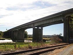
- Mark Clark Bridge
-
Mark Clark Bridge 
Carries Washington State Route 532 Crosses Stillaguamish River Locale Stanwood, Washington Opened 1949 Closed August 17, 2010 The Mark Clark Bridge, built in 1949, carried Washington State Route 532 across the Stillaguamish River to connect Stanwood, Washington to Camano Island. It provided the only road access to the island. The bridge was named to honor General Mark W. Clark, a decorated Army officer of World War II who earlier served at Fort Lewis and spent much of his retirement on Camano Island. The water surrounding Camano Island is too shallow for ferry service, which made this bridge a critical link for island residents and visitors.[1]
On August 17, 2010, the new Camano Gateway Bridge opened to traffic.[2] As a result, the Mark Clark bridge was closed to traffic. The following month, the Mark Clark Bridge was demolished.[3]
Camano Gateway Bridge
The Washington State Department of Transportation (WSDOT) began construction of a new bridge in the summer of 2009. According to WSDOT, the new bridge will:
- Measure 56 feet (17 m) wide to accommodate a future four lane SR532; the bridge will be initially configured for two 12-foot (3.7 m) lanes
- Match up with a realigned portion of the existing two lane highway
- Feature eight-foot-wide shoulders to provide bicyclists and pedestrians safer access and allow space for disabled vehicles to pull out of through lanes
- Meet modern earthquake safety standards
- Continue to accommodate marine travel on the Stillaguamish River".[4]
As mentioned above, the new bridge was dedicated as the Camano Gateway Bridge, and opened to traffic August 17, 2010.
References
- ^ http://www.wsdot.wa.gov/NR/rdonlyres/305EBF09-DA1B-414E-A08A-E94C3CF1767E/0/SR532Folio62207sm.pdf
- ^ http://www.scnews.com/news/2010-08-17/Front_Page/Camano_Gateway_Bridge_opens_to_traffic.html
- ^ http://www.scnews.com/news/2010-09-14/General_News/General_Mark_Clark_Bridge_demolished.html
- ^ New bridge, safer SR 532 in store for Stanwood and Camano Island residents, Washington State Department of Transportation, July 1, 2009, http://www.wsdot.wa.gov/News/2009/07/01_SR+532+Groundbreaking.htm, retrieved 2009-08-12
Coordinates: 48°14′25″N 122°22′59″W / 48.240266°N 122.383189°W
Categories:- Bridges completed in 2010
- Demolished bridges in the United States
- Buildings and structures in Snohomish County, Washington
- Road bridges in Washington (state)
- Washington (state) building and structure stubs
- United States bridge (structure) stubs
Wikimedia Foundation. 2010.
