- Anhui
-
Coordinates: 31°50′N 117°0′E / 31.833°N 117°E
Anhui Province Chinese : 安徽省 Ānhuī Shěng Abbreviations: 皖 (pinyin: Wǎn) 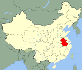
Origin of name 安 ān - Anqing
徽 huī - Huizhou (now Huangshan city)Administration type Province Capital
(and largest city)Hefei CPC Ctte Secretary Zhang Baoshun Governor Wang Sanyun Area 139,400 km2 (53,800 sq mi) (22nd) - Latitude 29° 24' to 34° 57' N - Longitude 114° 53' to 119° 39' E Population (2010)
- Density59,500,510 (8th)
440 /km2 (1,100 /sq mi) (9th)GDP (2010)
- per capitaCNY 1.22 trillion (US$181.1 billion) (14th)
CNY 16,391 (26th)HDI (2008) 0.750 (medium) (26th) Ethnic composition Han - 99%
Hui - 0.6%Spoken dialects {{{Dialects}}} Prefectural level 17 divisions County level 105 divisions Township level* 1845 divisions ISO 3166-2 CN-34 Official website
www.ah.gov.cn (simplified Chinese)Source for population and GDP data: 《中国统计年鉴—2005》 China Statistical Yearbook 2005Source for nationalities data:
ISBN 7503747382《2000年人口普查中国民族人口资料》 Tabulation on nationalities of 2000 population census of China*As at December 31, 2004
ISBN 7105054255Template ■ Discussion ■ WikiProject China Anhui Chinese 安徽 Hanyu Pinyin Ānhuī Transcriptions Gan - Romanization Ngon1 Fi1 Mandarin - Hanyu Pinyin Ānhuī - Wade–Giles An-hui
 [Listen] (help·info)
- Postal Map Ngan-hui, Anhwei or An-hwei Anhui (Chinese: 安徽; pinyin: Ānhuī; Wade–Giles: An-hui, Mandarin pronunciation: [ánxwéi]) is a province in the People's Republic of China. Located in eastern China across the basins of the Yangtze River and the Huai River, it borders Jiangsu to the east, Zhejiang to the southeast, Jiangxi to the south, Hubei to the southwest, Henan to the northwest, and Shandong for a tiny section in the north. The capital of the province is Hefei.
The name "Anhui" derives from the names of two cities in south Anhui, Anqing and Huizhou (now Huangshan City).[1] The abbreviation for Anhui is "皖" (Wǎn), because there were historically a State of Wan, a Mount Wan, and a Wan river in the province.
Contents
History
The province of Anhui was formed in the seventeenth century. Before then, there was no coherent concept of "Anhui". Northern Anhui was firmly a part of the North China Plain in terms of culture, together with modern-day Henan province. Central Anhui constituted most of the fertile and densely-populated Huai He River watershed. Southern Anhui, along the Yangtze, was closer to Hubei and southern Jiangsu provinces in culture. Finally, the hills of southeastern Anhui formed a unique and distinct cultural sphere of its own.
During the Warring States Period, Shouchun (modern Shou County) in central Anhui became a refugee capital for the state of Chu after its heartlands in modern Hubei province was overrun by the powerful state of Qin in the west, in 278 BC. Qin nevertheless managed to conquer all of China in 221 BC, creating the Qin Dynasty.[citation needed]
Anhui was administered under several different commanderies during the Qin Dynasty and the Han Dynasty. Near the end of the Han Dynasty, Shouchun became the base for the warlord Yuan Shu, who declared himself emperor at one point, but soon succumbed to illness, allowing his small realm to come under the powerful warlord Cao Cao, founder of the Wei Kingdom, one of the Three Kingdoms.[citation needed]
The 4th century saw the influx of nomadic tribes from Central Asia into North China. This began several centuries of political division of northern and southern China. Being at the juncture of north and south, the lands comprising modern Anhui changed hands frequently and was usually bisected through the middle politically. The Battle of Feishui, between the Former Qin of the north and the Eastern Jin Dynasty of the south, took place in 383 AD in modern Anhui.[citation needed]
The Sui Dynasty (581-618) and the Tang Dynasty (618-907) oversaw several centuries of relative peace and unity in China. During this period Anhui was once again ruled under several different jurisdictions.[citation needed]
During the division of China between the Jin Dynasty in the north and the Southern Song Dynasty in the south, Anhui was once again bisected, this time along the Huai He River. This lasted until Mongol reunification of China in 1279.[citation needed]
The Ming Dynasty drove out the Mongols in 1368. Due to a short stint as the capital of China by the city of Nanjing in nearby Jiangsu province, the entirety of Jiangsu and Anhui kept their special status as territory-governed directly by the central government, and were called Nanzhili (南直隸 "Southern directly-governed").[citation needed]
The Manchu Qing Dynasty, which conquered China in 1644, changed this situation by establishing Nanzhili as Jiangnan province; in 1666 Jiangsu and Anhui were split apart as separate provinces. This was the beginning of the contemporary Anhui province, which has since kept almost the same borders as today. The one significant change that occurred was the move of the provincial capital from Anqing to Hefei in 1946.[citation needed]
When the People's Republic of China was founded in 1949, Anhui was briefly split into two separate administrative regions: Wanbei (North Anhui) and Wannan (South Anhui). They were merged into a province in 1952.[citation needed]
In the 2007 book China Road, author Rob Gifford stated that the Chinese refer to Anhui as a "big agricultural province" (农业大省). According to Gifford, this is a euphemism for a "very poor" area and that people have referred to Anhui as the "Appalachia of China."[2]
Geography
 A street in Zhide (至德), a town, historically known as Yaodu (尧度), in southern Anhui's Dongzhi County, Chizhou.
Anhui is quite diverse topographically. The north of the province is part of the North China Plain while the north-central areas are part of the Huai He River watershed. Both of these regions are very flat and densely populated. The land becomes more uneven further south, with the Dabie Mountains occupying much of southwestern Anhui and a series of hills and ranges cutting through southeastern Anhui. The Yangtze River finds its way through south Anhui in between these two mountainous regions. The highest peak in Anhui is Lotus Peak, part of the Huangshan Mountains in southeastern Anhui. It has an altitude of 1873 m.
Major rivers include the Huai He in the north and the Yangtze in the south. The largest lake is Lake Chaohu in the center of the province, with an area of about 800 km². The southeastern part of the province near the Yangtze River has many lakes as well.
As with topography, the province differs in climate from north to south. The north is more temperate and has more clearcut seasons. January temperatures average at around -1 to 2 °C north of the Huai He, and 0 to 3 °C south of the Huai He; in July temperatures average 27 °C or above. Plum rains occur in June and July and may cause flooding.
Major cities:
Administrative divisions
Anhui is divided into seventeen prefecture-level divisions:
Map # Name Hanzi Hanyu Pinyin Administrative Seat Population (2010) 
— Prefecture-level city — 1 Hefei 合肥市 Héféi Shì Luyang District 7,457,000 2 Anqing 安庆市 Ānqìng Shì Yingjiang District 5,311,000 3 Bengbu 蚌埠市 Bèngbù Shì Longzihu District 3,164,000 4 Bozhou 亳州市 Bózhōu Shì Qiaocheng District 4,851,000 6 Chizhou 池州市 Chízhōu Shì Guichi District 1,403,000 7 Chuzhou 滁州市 Chúzhōu Shì Langya District 3,938,000 8 Fuyang 阜阳市 Fǔyáng Shì Yingzhou District 7,600,000 9 Huaibei 淮北市 Huáiběi Shì Lieshan District 2,114,000 10 Huainan 淮南市 Huáinán Shì Tianjia'an District 2,334,000 11 Huangshan 黄山市 Huángshān Shì Tunxi District 1,359,000 12 Lu'an 六安市 Lù'ān Shì Jin'an District 5,612,000 13 Ma'anshan 马鞍山市 Mǎ'ānshān Shì Yushan District 2,304,000 14 Suzhou 宿州市 Sùzhōu Shì Yongqiao District 5,353,000 15 Tongling 铜陵市 Tónglíng Shì Tongguanshan District 724,000 16 Wuhu 芜湖市 Wúhú Shì Jinghu District 3,443,000 17 Xuancheng 宣城市 Xuānchéng Shì Xuanzhou District 2,533,000 The seventeen prefecture-level divisions of Anhui are subdivided into 105 county-level divisions (44 districts, five county-level cities, and 56 counties). Those are in turn divided into 1845 township-level divisions (972 towns, 634 townships, nine ethnic townships, and 230 subdistricts).
See List of administrative divisions of Anhui for a complete list of county-level divisions.
Politics
Main article: Politics of AnhuiThe Politics of Anhui Province is structured in a dual party-government system like all other governing institutions in mainland China.
The Governor of Anhui (Chinese: 安徽省省长) is the highest ranking official in the People's Government of Anhui. However, in the province's dual party-government governing system, the Governor has less power than the Anhui Communist Party of China Provincial Committee Secretary (Chinese: 安徽省委书记), colloquially termed the "Anhui Party Chief".
Economy
Agriculture in Anhui varies according to the climate zones that the province crosses. North of the Huai He river wheat and sweet potatoes are grown, while south of the Huai He it is rice and wheat instead.
Natural resources of Anhui include iron in Ma'anshan, coal in Huainan, and copper in Tongling. There are industries related to these natural resources (e.g. steel industry at Ma'anshan). One of the famous Anhui-based corporations is the automobile company Chery, which is based in Wuhu.
Compared to its more successful neighbours to the east, Zhejiang and Jiangsu, Anhui has lagged markedly behind in economic development, with a GDP per capita around one third the level of those two provinces. There is great regional disparity as well, and most of the wealth is concentrated in industrial regions close to the Yangtze River, such as Hefei, Wuhu, and Ma'anshan.
Anhui's nominal GDP for 2010 was approximately 1.22 trillion yuan (US$181.1 billion), up 12.9% from 2008 and a per capita of 16,391 yuan (US$2,400). It is considered a mid-size economy in terms of economic output. Anhui's GDP is largely driven by fixed-asset investment, and the province's GDP to FAI ratio as of 2009 was 0.89, the highest in China.[3]
Anhui's largest companies include Anhui Conch Cement Company, a producer and distributor of cement, Guoyang Securities Co (SHE: 000728), a financial services provider, and Ma’anshan Iron & Steel, a producer of steel and iron.[4]
Major Economic and Technological Development Zones
Hefei Economic and Technological Development Zone
Hefei Economic and Technological Development Zone is located in the southwest of Hefei. The zone is divided into two functional areas. The east part is allocated for manufacturing purpose and it also has two parks; the west part is where the business center, Hefei university town, and the international community center are located. It is established in 1993, and it is located close to Hefei Luogang International Airport.[5]
Hefei Hi-Tech Industrial Development Zone
Hefei Hi-Tech Industrial Development Zone was founded in October 1990 and approved by the State Council as a state-level Development Zone in March 1991. In 1997, the Development Zone was ratified as an APEC Science and Technology Industrial Park, with special open policies to APEC and EU members. Hefei High Tech Park was also approved as a National High Tech Export Base in 2000 and obtained the award of a Advanced High Tech Zone under the Torch Program in 2003. So far, more than 100 hi-tech enterprises have entered the zone. Industries encouraged in the zone include Chemicals Production and Processing, Electronics Assembly & Manufacturing, Heavy Industry, Instruments & Industrial Equipment Production, Medical Equipment and Supplies, Research and Development, Telecommunications Equipment.[6]
Wuhu Economic and Technological Development Zone
Established in 1993, Wuhu Economic & Technological Development Zone is the first state-level development zone approved by central government in Anhui Province. As the hub in the west of the Yangtze Delta, it is an ideal place for business in Central China and East China such as manufacturing place or logistic center due to great transportation advantage. Wuhu port is the last fine deepwater port here going against the Yangtse River. It is the main foreign trade base and overseas transportation center. It takes 1 hour from Wuhu to Nanjing Lukou International Airport and to Hefei Luogang Airport.[7]
Wuhu Export Processing Zone
Wuhu Export Processing Zone was approved to be a national level export processing zone by State Council. Wuhu Export Processing Zone is located in the Wuhu EDZ, with a total planned area of 2.95 sqkm with the first-stage are being 1.1 sqkm. It is located close to Wuhu Airport and Wuhu Port. Industries encouraged in the zone include Electronics Assembly & Manufacturing, Heavy Industry, Instruments & Industrial Equipment Production, Shipping/Warehousing/Logistics, Trading and Distribution.[8]
Demographics
Han Chinese make up the vast majority of the population. The Hui and She nationalities are the two largest minorities.
Anhui has a highly unbalanced gender ratio. According to a 2009 study published in the British Medical Journal, in the 1-4 age group, there are 138 boys for every 100 girls, making it among the most unbalanced of provinces in China.[9]
Culture
Anhui spans many geographical and cultural regions. The northern, flatter parts of the province, along the river Huai He and further north, are most akin to neighbouring provinces like Henan and Shandong. In contrast, the southern, hilly parts of the province are more similar in culture and dialect to other southern, hilly provinces, like Zhejiang and Jiangxi.
Mandarin dialects are spoken over the northern and central parts of the province, north of the Yangzi river. Dialects to the north (e.g. Bengbu dialect) are classified as Zhongyuan Mandarin, together with dialects in provinces such as Henan and Shandong; dialects in the central parts (e.g. Hefei dialect) are classified as Jianghuai Mandarin, together with dialects in the central parts of neighbouring Jiangsu province. Non-Mandarin dialects are spoken to the south of the Yangzi: dialects of Wu are spoken in Xuancheng prefecture-level city, though these are rapidly being replaced by Jianghuai Mandarin; dialects of Gan are spoken in a few counties in the southwest bordering Jiangxi province;[10] and the Huizhou dialects are spoken in about ten counties in the far south, a small but highly diverse and unique group of Chinese dialects.
Huangmeixi, which originated in the environs of Anqing in southwestern Anhui, is a form of traditional Chinese opera popular across China. Huiju, a form of traditional opera originating in the Huizhou-speaking areas of southern Anhui, is one of the major precursors of Beijing Opera; in the 1950s, Huiju (which had disappeared) was revived. Luju is a type of traditional opera found across central Anhui, from east to west.
Anhui cuisine is one of the eight great traditions of Chinese cuisine. Combining elements of cooking from northern Anhui, south-central Anhui, and the Huizhou-speaking areas of southern Anhui, Anhui cuisine is known for its use of wild game and herbs, both land and sea, and comparatively simple methods of preparation.
Anhui has a high concentration of traditional products related to calligraphy: Xuanzhou (today Xuancheng) and Huizhou (today Huangshan City) are revered for producing Xuan Paper and Hui Ink, respectively, which are traditionally considered the best types of paper and ink for Chinese calligraphy. She County is famous for the She Inkstone, one of the most preferred types of inkstones (a required tool in traditional calligraphy).
Tourism
Anhui's principal tourism sites include the following:
- Ancient Villages in Southern Anhui - Xidi and Hongcun (World Heritage Site).
- Mount Huangshan (World Heritage Site)
- Mount Jiuhua
- Mount Qiyun
- Mount Tianzhu
- Old Town of Tunxi
- Mount Langya
- Zuiweng Pavilion, named after the poet Ouyang Xiu (1007–1072 CE).
- Chao Lake
- Taiji Cave, the longest karst cave in East China.
- Zhenfeng Pagoda, a Ming Dynasty pagoda in Anqing City.
Development
In 2008, France helped the Anhui Provincial Tourism Bureau develop a rural tourism demonstration project.[11]
Notable people
- Gao Yao (皋陶) (lived in the 21st century BCE), political advisor of the Yu the Great.
- Guan Zhong (管仲) (720-645 BC), Prime Minister of Duke Huan of Qi.
- Zhuang Zi (庄子) (369-286 BC), philosopher of Taoism.
- Fan Zeng (范增) (277-204 BC), advisor to Xiang Yu.
- Liu An (刘安) (179-122 BC), King of Huainan.
- Hua Tuo (华陀) (140-208), physician.
- Cao Cao (曹操) (155-220), warlord and the penultimate chancellor of the Eastern Han Dynasty.
- Cao Pi (曹丕) (187-226), Emperor Wen of Wei, first emperor of the state of Cao Wei.
- The Three Kingdoms era Cao Wei generals Cao Ren (曹仁) , Cao Hong (曹洪) , Xiahou Dun (夏侯惇) , Xiahou Yuan (夏侯渊) , Cao Zhen (曹真).
- The Three Kingdoms era Sun Wu generals Zhou Yu (周瑜) , Lu Su (鲁肃) , Lü Meng (吕蒙).
- Ji Kang (嵇康) (223–262), musician.
- Huan Wen (桓温) (312–373), general of the Jin Dynasty.
- Huan Xuan (桓玄) (369–404), founder of the state of Huan Chu.
- Emperor Taizu of Later Liang (852–912)
- Yang Xingmi (852–905)
- Bao Zheng (包拯) (999–1062)
- Li Gonglin (李公麟) (1049–1106), painter.
- Zhu Xi (朱熹) (1130–1200), philosopher of Neo-Confucianism.
- Zhu Yuanzhang (朱元璋) (1328-1398), Hongwu Emperor, founder and first emperor of the Ming Dynasty.
- The Ming Dynasty generals Xu Da (徐达), Chang Yuchun (常遇春), Tang He (汤和), Mu Ying (沐英).
- Hong Ren (弘仁), painter.
- Zhang Tingyu (张廷玉), politician and historian of Qing Dynasty.
- Yao Nai (姚鼐), main figure of Tongcheng Schoolof Qing Dynasty.
- Wu Jingzi (吴敬梓) (1701—1754)
- Dai Zhen (戴震) (1724-1777), a notable scholar.
- Cheng Changgeng (程长庚) (1811-1880), one of the founders of Beijing opera.
- Li Hongzhang (李鸿章) (1823-1901), leading statesman of the late Qing Empire.
- Liu Mingchuan (刘铭传) (1836–1896), first governor of the province of Taiwan.
- Jeme Tien Yow (詹天佑) (1861-1919)
- Duan Qirui (段祺瑞) (1865-1936), warlord and politician, commander in the Beiyang Army.
- Feng Yuxiang (冯玉祥) (1882-1948), warlord and leader in Republican China.
- Hu Shih (胡适) (1891-1962), philosopher, essayist and diplomat.
- Zhang Zhizhong (张治中) (1895-1969), Kuomintang (KMT) General.
- Wei Lihuang (卫立煌) (1897-1960), Kuomintang (KMT) General.
- Sun Li-jen (孙立人) (1900-1990), Kuomintang (KMT) General.
- Tao Xingzhi (陶行知) (1891-1946), a renowned Chinese educator and reformer.
- Chen Duxiu (陈独秀) (1879-1942), co-founder of the Chinese Communist Party.
- Wang Ming (王明) (1904-1974), senior leader of the early Chinese Communist Party.
- Wang Jiaxiang (王稼祥) (1906-1974), one of the senior leaders of the early Communist Party of China.
- Li Kenong (李克农) (1899–1962), a major figure of Chinese Communist intelligence.
- Ke Qingshi (柯庆施) (1902-1965)
- Zhu Guangqian (朱光潜), founder of the study of aesthetics in 20th c. China.
- Zhao Puchu (赵朴初) (1907-2000), religious and public leader.
- Yu Ying-shih (余英时), Chinese American historian.
- Yan Fengying (严凤英), performing artist of Huangmei opera.
- Huang Binhong (黄宾虹), painter.
- Wu Zuoren (吴作人), painter.
- Deng Jiaxian (邓稼先), leading organizer and key contributor to the Chinese nuclear weapon programs.
- Chen Ning Yang (杨振宁), Chinese-American physicist who won the 1957 Nobel prize in physics.
- Xu Haifeng (许海峰), first person to win a gold medal for China in the Olympic Games.
- Jin Jing
- Hu Jintao (胡锦涛), current General Secretary of the Communist Party of China, President of the People's Republic of China
Colleges and universities
See also: List of universities and colleges in Anhui- Anhui Agricultural University, in Hefei
- Anhui Normal University, in Wuhu
- Anhui University, in Hefei
- Anhui University of Finance and Economics, in Bengbu
- Anhui University of Technology, in Ma'anshan
- Hefei University of Technology
- Anhui University of Technology and Science, in Wuhu
- University of Science & Technology of China, located in the Southwest part of Hefei
- Anhui University of Traditional Chinese Medicine
- Anhui University of Science & Technology, in Huainan
- Wannan Medical College, in Wuhu
- Huainan Institute of Technology, in Huainan
- Correspondence College of Computer of China
- Chizhou University, in Chizhou
- Chuzhou Normal Academy, in Chuzhou
- Anhui Sanlian College, in Hefei
- Electronic Engineering College of Hefei
- Huaibei Coal Industry Normal College
- Anqing Teachers College, in Anqing
- Hefei Normal University, in Hefei
See also
References
- ^ (Chinese) Origin of the Names of China's Provinces, People's Daily Online.
- ^ Gifford, Rob. "A Single Spark Can Light a Prairie Fire." China Road. 53.
- ^ http://www.thechinaperspective.com/topics/province/anhui-province/
- ^ The China Perspective | Anhui Province Economic News and Data
- ^ RightSite.asia | Hefei Economic and Technological Development Zone
- ^ RightSite.asia | Hefei Hi-Tech Industrial Development Zone
- ^ RightSite.asia | Wuhu Economic & Technological Development Zone
- ^ RightSite.asia | Wuhu Export Processing Zone
- ^ [1]
- ^ China (11, illustrated ed.). Lonely Planet. 2009. p. 437. ISBN 1741048664. http://books.google.com/books?id=K4undxTsMmIC&pg=PA437&dq=jianghuai+mandarin&hl=en&ei=EqZ_TrysOqq80AHql43oDw&sa=X&oi=book_result&ct=result&resnum=5&ved=0CDsQ6AEwBDgK#v=snippet&q=jianghuai%20mandarin&f=false. Retrieved 23 September 2011.
- ^ Anhui Cooperates With France To Build Rural Tourism Area
External links
- Anhui Government website
- Anhui Provincial Tourism Administration Official Site
- Economic profile for Anhui Province at HKTDC
 Chisholm, Hugh, ed (1911). "Ngan-hui". Encyclopædia Britannica (11th ed.). Cambridge University Press.
- Anhui Province Guide

Henan Shandong Jiangsu 
 Anhui
Anhui 

Hubei Jiangxi Zhejiang Anhui topics General Geography Cities • North China Plain • Huai He River • Dabie Mountains • Yangtze River • Huangshan Mountains • Lake ChaohuEducation Culture Huangmeixi operaCuisine Visitor attractions Mount Huangshan • Mount Jiuhua • Mount Qiyun • Mount Tianzhu • Zuiweng Pavilion • Taiji Cave • Zhenfeng PagodaAnhui Province county-level divisions Hefei: Luyang District · Yaohai District · Shushan District · Baohe District · Chaohu City · Changfeng County · Feidong County · Feixi County · Lujiang County Anhui in China
Wuhu: Jinghu District · Sanshan District · Jiujiang District · Yijiang District · Wuhu County · Fanchang County · Nanling County · Wuwei County
Bengbu: Bengshan District · Longzihu District · Yuhui District · Huaishang District · Huaiyuan County · Wuhe County · Guzhen County
Huainan: Tianjia'an District · Datong District · Xiejiaji District · Bagongshan District · Panji District · Fengtai County
Ma'anshan: Yushan District · Huashan District · Jinjiazhuang District · Dangtu County · Hanshan County · He County
Huaibei: Xiangshan District · Duji District · Lieshan District · Suixi County
Tongling: Tongguanshan District · Shizishan District · Jiaoqu District · Tongling County
Anqing: Yingjiang District · Daguan District · Yixiu District · Tongcheng City · Huaining County · Zongyang County · Qianshan County · Taihu County · Susong County · Wangjiang County · Yuexi County
Huangshan: Tunxi District · Huangshan District · Huizhou District · She County · Xiuning County · Yi County · Qimen County
Chuzhou: Langya District · Nanqiao District · Mingguang City · Tianchang City · Lai'an County · Quanjiao County · Dingyuan County · Fengyang County
Fuyang: Yingzhou District · Yingdong District · Yingquan District · Jieshou City · Linquan County · Taihe County · Funan County · Yingshang County
Suzhou: Yongqiao District · Dangshan County · Xiao County · Lingbi County · Si County
Lu'an: Jin'an District · Yu'an District · Shou County · Huoqiu County · Shucheng County · Jinzhai County · Huoshan County
Bozhou: Qiaocheng District · Woyang County · Mengcheng County · Lixin County
Chizhou: Guichi District · Dongzhi County · Shitai County · Qingyang County
Xuancheng: Xuanzhou District · Ningguo City · Langxi County · Guangde County · Jing County · Jingde County · Jixi CountyProvincial level divisions of the People's Republic of China Provinces 
Autonomous regions Municipalities Special Administrative Regions Territorial disputes - Paracel, Spratly, Zhongsha Islands (see Paracels, Spratlys, & Zhongsha Iss. Authority)
- Pratas Islands
- Senkaku Islands
- South Tibet
- Taiwan, Kinmen & Matsu (see Legal status of Taiwan)
Categories:- Anhui
- Provinces of the People's Republic of China
- 17th-century establishments
- States and territories established in 1952


Wikimedia Foundation. 2010.