- Denial Bay, South Australia
-
Denial Bay
South Australia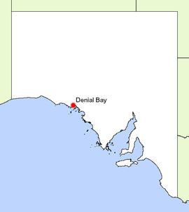
Location of Denial Bay in South AustraliaPopulation: 356[1] Established: 1889 Postcode: 5690 Elevation: 1 m (3 ft) Location: 14 km (9 mi) North West of Ceduna LGA: District Council of Ceduna State District: Flinders Federal Division: Grey Denial Bay is a small fishing and tourist village that lies on the bay of the same name, only 14 km from Ceduna on the Western Eyre Peninsula, South Australia, facing the Nuyts Archipelago. The town has extensive European history, first built on in 1889, and now hosts a large expanse of oyster farms, one of the largest on the Eyre Peninsula.
Contents
History
The bay that the town lies on was initially mapped by Matthew Flinders in 1802, as part of a wider attempt to map South Australia's coastline. Flinders named the inlet "Denial Bay" because of "the deceptive hope we had formed of penetrating by it some distance into the interior of the country".[2]
The town was established by William McKenzie in 1889 as the first settlement in what was to become the Ceduna area. McKenzie nearly single handedly set up the town, clearing mallee scrub by axe, building a general store and becoming the local harbour master, postman, blacksmith, butcher, saddler and Justice of the Peace, employing up to 30 people at any one time.[3]
The town established primarily as a loading and offloading point for the various inland farming activities, and this was done using a unique system based on the rocky floor of the bay's seabed.
A large wooden platform known as 'McKenzie's Landing' was constructed and at high tide, boats would unload goods onto the platform and at low tides horse and cart would be used to collect the items. The same would be done to load boats.[4]
During this peak of activity, a school opened in 1897 and continued operation until 1945.[2] In 1909, a jetty was constructed south of McKenzie's Landing after a 1905 proposal, and still stands today.[2]
Another piece of history at Denial Bay is the famous dog fence which runs down to the water near McKenzie's Landing.[5]
The town has long since ceased functioning as a port, and today relies on the aquaculture industry, as well as tourism.
Economy
The economy of Denial Bay now depends heavily on the production of Oysters by aquaculture, as well as minor inputs from tourism.
Oyster farming was established in the area in 1985, with 105 Ha of intertidal farms allocated to farmers within the bay. The maximum size per individual farm was 10 Ha. This has since increased to over 200 Ha in Denial and Murat Bays.[6]
The oysters grown in both the Denial Bay and Smoky Bay regions account for approximately 20% of all oysters grown in the state. The oyster growing industry is celebrated each year during 'Oysterfest' in Ceduna.[6]
Tourism in the town is centered around recreational fishing and other marine based activities such as snorkelling, scuba diving, swimming and even surfing along some parts of the coast.
The bay has an unusually high density of the Blue Swimmer Crab, making it a popular destination for crabbers, with crabs caught off the jetty or by boat. Other notable species caught in the bay include Snapper, King George and Yellowfin Whiting, Salmon, Mulloway, Shark and Squid, as well as a host of other species.[7]
Facilities
Denial Bay is a very small town, and as such has very limited facilities. The town does have a small general store that sells petrol and groceries, with a public payphone located nearby. A full range of shopping and business services is located in Ceduna only 12 kilometres away by sealed road.[4]
The town has very little in the way of accommodation, sporting grounds, eateries or other services.
References
- ^ Australian Bureau of Statistics (25 October 2007). Denial Bay (State Suburb). 2006 Census Quickstats. Retrieved on 2008-05-25
- ^ a b c State Library of South Australia Manning Index, Denial Bay, http://www.slsa.sa.gov.au/manning/pn/d/d2.htm#denialB, retrieved 2007-06-14
- ^ Ceduna District Council, Denial Bay, http://www.ceduna.net/site/page.cfm?u=191, retrieved 2007-06-14
- ^ a b Nullabor Net, Denial Bay, http://www.nullarbornet.com.au/towns/denialBay.html, retrieved 2007-06-14
- ^ Sydney Morning Herald Travel (2004-02-08), Ceduna, The Sydney Morning Herald, http://www.smh.com.au/news/South-Australia/Ceduna/2005/02/17/1108500204196.html, retrieved 2007-06-14
- ^ a b Oysterfest Site, History, http://www.communitywebs.org/CedunaOysterFest/oysterfarms.htm, retrieved 2007-06-14
- ^ Eyre Peninsula Tourism, Eyre Peninsula Fishing Code, http://www.tep.com.au/region_fishing.htm, retrieved 2007-06-14
External links
Towns and Localities of the District Council of Ceduna Eyre Peninsula, South Australia Cities Townships Arno Bay · Baird Bay · Ceduna · Cleve · Coffin Bay · Cowell · Cummins · Darke Peak · Denial Bay · Elliston · Iron Knob · Kimba · Kyancutta · Lock · Minnipa · Poochera · Port Kenny · Port Neill · Pygery · Sceale Bay · Smoky Bay · Streaky Bay · Thevenard · Tumby Bay · Venus Bay · Wangary · Wirrulla · Wudinna · Yaninee · YeelannaNational parks Coffin Bay National Park · Gawler Ranges National Park · Lake Gilles Conservation Park · Lincoln National ParkIslands Councils Categories:- Towns in South Australia
- Coastal towns in South Australia
- Eyre Peninsula
- Bays of South Australia

Wikimedia Foundation. 2010.