- Dederang, Victoria
-
Dederang
Victoria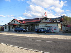
The Dederang Hotel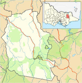
 Dederang
Population: 422[1] Postcode: 3691 Coordinates: 36°29′S 147°01′E / 36.483°S 147.017°ECoordinates: 36°29′S 147°01′E / 36.483°S 147.017°E Elevation: 271 m (889 ft) Location: - 329 km (204 mi) north east of Melbourne
- 48 km (30 mi) south of Wodonga
- 39 km (24 mi) north west of Mount Beauty
- 24 km (15 mi) south east of Yackandandah
LGA: Alpine Shire State District: Benambra Federal Division: Indi Mean max temp Mean min temp Annual rainfall 26.6 °C
80 °F10.1 °C
50 °F769.7 mm
30.3 inDederang is a town in north east Victoria. The town is located on the Kiewa Valley Highway, in the Alpine Shire Local Government Areas of Australia, 329 kilometres from the state capital, Melbourne. Dederang is located in the Kiewa River valley. At the 2006 census, Dederang and the surrounding area had a population of 422.[1]
Dederang Post Office opened on 1 September 1877 and closed in 1977.[2]
The town is a popular trout fishing centre and holds a New Year's Day race meeting as well as the annual gumboot throwing championships.[3]
The town in conjunction with neighbouring township Mount Beauty has an Australian Rules football team Dederang-Mount Beauty competing in the Tallangatta & District Football League.
Dederang has a picnic horse racing club, the Dederang Picnic Race Club, which holds its one race meeting a year with the Dederang Cup in January.[4]
Golfers play at the Dederang Golf Club on the Kiewa Valley Highway.[5]
References
- ^ a b Australian Bureau of Statistics (25 October 2007). "Dederang (State Suburb)". 2006 Census QuickStats. http://www.censusdata.abs.gov.au/ABSNavigation/prenav/LocationSearch?collection=Census&period=2006&areacode=SSC25455&producttype=QuickStats&breadcrumb=PL&action=401. Retrieved 2007-07-26.
- ^ Premier Postal History, Post Office List, https://www.premierpostal.com/cgi-bin/wsProd.sh/Viewpocdwrapper.p?SortBy=VIC&country=, retrieved 2008-04-11
- ^ Dederang, Travelmate, http://www.travelmate.com.au/Places/Places.asp?TownName=Dederang_%5C_VIC, retrieved 2007-06-10
- ^ Country Racing Victoria, Dederang Picnic Race Club, http://www.countryracing.com.au/index.php?option=com_club_info&club=71&Itemid=80, retrieved 2009-05-07[dead link]
- ^ Golf Select, Dederang, http://www.golfselect.com.au/armchair/courseView.aspx?course_id=962, retrieved 2009-05-11
Towns in Alpine Shire Barwidgee · Bright · Dederang · Dinner Plain · Eurobin · Harrietville · Kancoona · Mount Beauty · Myrtleford · Ovens · Porepunkah · Rosewhite · Tawonga · Tawonga South · Wandiligong
Categories:- Towns in Victoria (Australia)
- Victoria (Australia) geography stubs


Wikimedia Foundation. 2010.