- Maryland Route 371
-
Maryland Route 371
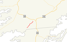
Maryland Route 371 highlighted in redRoute information Maintained by MDSHA Length: 4.27 mi[1] (6.87 km) Major junctions South end: Cedar Hall Wharf Road in Cedar Hall North end: Broad Street in Pocomoke City Location Counties: Worcester Highway system Maryland highway system
Interstate • US • State • Minor • Former • Turnpikes←  MD 370
MD 372  →
→Maryland Route 371 (MD 371) is a state highway in the U.S. state of Maryland. Known for most of its length as Cedar Hall Road, the state highway runs 4.27 miles (6.87 km) from Cedar Hall Wharf Road in Cedar Hall north to Broad Street in Pocomoke City. MD 371 was constructed in segments in the first half of the 1930s. The state highway serving the southwest corner of Worcester County has been isolated from the rest of the state highway system since the northern terminus was rolled back from U.S. Route 13 Business (US 13 Business) in the 1990s.
Contents
Route description
MD 371 begins in Cedar Hall near the intersection with Colona Road. Cedar Hall Wharf Road continues south as a county highway to a boat ramp on the Pocomoke River.[2] MD 371 heads northeast as a two-lane road through farmland and forest.[1] After the Pocomoke Beltway, which leads to US 13 and US 113, splits off to the east, the state highway turns north and passes Dun Swamp Road.[2] Upon entering the city limits of Pocomoke City, the road's name changes to Second Street.[1] MD 371 reaches its northern terminus at the intersection with Broad Street.[1] Second Street continues east as a municipal street toward US 13 Business.[2]
History
The first segment of MD 371 was paved in 1929 and 1930 from Pocomoke City to Hillman Road.[3][4] The second segment, south to New Bridge Road, was built between 1930 and 1933.[3][5] The final segment of MD 371 to Cedar Hall was constructed between 1934 and 1936.[6][7] The state highway originally continued into Pocomoke City and ended at US 13. The northern terminus was rolled back to Broad Street by 1999.[8]
Junction list
The entire route is in Worcester County.
Location Mile
[1]Destinations Notes Cedar Hall 0.00 Cedar Hall Wharf Road south Southern terminus Pocomoke City 3.11 Pocomoke Beltway east to US 13 / US 113 – Princess Anne, Snow Hill, Norfolk 3.72 Dun Swamp Road south Former MD 576 4.27 Broad Street south / Second Street east to US 13 Bus. Northern terminus 1.000 mi = 1.609 km; 1.000 km = 0.621 mi References
- ^ a b c d e "Highway Location Reference: Worcester County" (PDF). Maryland State Highway Administration. 2009. http://www.marylandroads.com/Location/2009_WORCESTER.pdf. Retrieved 2010-10-24.
- ^ a b c Google, Inc. Google Maps – Maryland Route 371 (Map). Cartography by Google, Inc. http://maps.google.com/maps?f=d&source=s_d&saddr=Cedar+Hall+Wharf+Rd&daddr=2nd+St&geocode=FfchRAIdYkh--w%3BFajZRAId1d1--w&hl=en&mra=ls&sll=38.045928,-75.578556&sspn=0.06205,0.154324&ie=UTF8&ll=38.043089,-75.590572&spn=0.062053,0.154324&t=h&z=13. Retrieved 2010-04-03.
- ^ a b Report of the State Roads Commission of Maryland. 1927-1930. Baltimore: Maryland State Roads Commission. 1930-10-01. p. 235. http://www.archive.org/details/annualreportsofs1927mary. Retrieved 2010-04-03.
- ^ Maryland Geological Survey. Map of Maryland Showing State Road System: State Aid Roads and Improved County Road Connections (Map) (1930 ed.).
- ^ Maryland Geological Survey. Map of Maryland Showing State Road System: State Aid Roads and Improved County Road Connections (Map) (1933 ed.).
- ^ Report of the State Roads Commission of Maryland. 1931-1934. Baltimore: Maryland State Roads Commission. 1934-12-28. p. 363. http://www.archive.org/details/annualreportsofs1931mary. Retrieved 2010-04-03.
- ^ Maryland State Roads Commission. Map of Maryland Showing State Road System (Map) (1936 ed.).
- ^ "Highway Location Reference: Worcester County" (PDF). Maryland State Highway Administration. 1999. http://www.marylandroads.com/Location/1999_WORCESTER.pdf. Retrieved 2010-10-24.[dead link]
External links
Roads in Worcester County, Maryland State highways 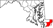
U.S. Highways Categories:- State highways in Maryland
- Roads in Worcester County, Maryland


Wikimedia Foundation. 2010.