- The Coorong District Council
-
Coorong District Council
South Australia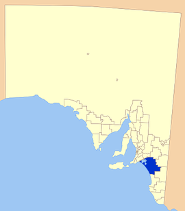
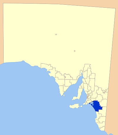
Location of the Coorong District CouncilPopulation: 5,825(2009)[1] Established: 1995 Area: 8830.6 km² (3,409.5 sq mi) Mayor: Roger Strother Council Seat: Meningie Region: River Murray, Limestone Coast State District: Hammond, MacKillop Federal Division: Barker LGAs around Coorong District Council: Murray Bridge Karoonda East Murray Southern Mallee Coorong District Council Tatiara Kingston  Former District Council of Coonalpyn Downs' logo
The Coorong District Council is a local government area located between the River Murray and the western Limestone Coast in South Australia. The district cover mostly rural areas with small townships, as well as the Coorong National Park.
The council was formed in 1995, when the District Council of Coonalpyn Downs amalgamated with the Peake District Council and Meningie District Council to form the Coorong District Council. It is geographically the largest council area in South Australia. The economy of the district is based mostly around agriculture.
Contents
Economy
Agriculture is prominent in the district, with grain crops the predominant land use. Due to improvement of grain crops in the area, district grain storage near Tailem Bend now holds up to 236 000 tonnes, after a large expansion in 1999.[2]
The region has a well established dairy industry, as well as various other livestock. Olives have been found to suit the climate and soil of the area and may be a potential industry in the future.[2]
The council purchased the old Mitsubishi Car Test Track property at the junction of the Dukes and Mallee Highways, and has leased the park out to enable South Australia's newest motorsport venue with Tailem Bend Motorsport Park Pty Ltd announcing that it is now holding activities and events and accepting bookings. The Tailem Bend Motorsport Park is a new multi sport motorsport park. Motorcycling SA and the Sporting Car Club of SA have joined forces to establish the park under the auspices of CAMS and Motorcycing Australia.
Localities
The Coorong District Council has offices in Meningie, Tailem Bend and Tintinara. The Chief Executive Officer and the three managers operate out of Tailem Bend, where the Council has just opened its first Customer Service Centre on 25 May 2010. This centre is located on Willow Street, around the corner from its previous office at the Tailem Bend Town Hall.
The district's full list of towns and divisions is:
Albert Hill, Ashville, Bedford, Buccleuch, Bunbury, Campbell Park, Carcuma, Colebatch, Cooke Plains, Coomandook, Coombe, Coonalpyn, Coorong, Culburra, Elwomple, Field, Grasslands, Jabuk, Jack's Point, Ki-Ki, Malinong, Marmon Jabuk, McGrath Flat, Meningie, Meningie West, Meningie East, Messent, Moorlands, Narrung, Naturi, Netherton, Ngarkat, Parnka Point, Peake, Policemans Point, Poltalloch, Raukkan, Rupari, Salt Creek, Sherlock, Stony Well, Tailem Bend, Tintinara, Waltowa, Wellington East, Woods Well, Yalkuri and Yumali.[3]
Elected Members
Mayor:
- Cr. Roger Strother
Councillors:
- Cr. Sharon Bland
- Cr. Richard Harkness
- Cr. Alison Jaensch
- Cr. Neville Jaensch
- Cr. Jeff Klitscher
- Cr. Denise Richardson
- Cr. Paul Simmons
- Cr. Peter Wright
- Chief Executive Officer: Michael Boyd
2009/2010 Major Works
Major capital works for 2009/2010 include
- New State of the Art Wastewaster Treatment Plants to replace old facilities at Meningie, Tailem Bend and Tintinara with the treated water recycled for irrigation on sports ovals, plant areas and golf courses.
- Reconstruction and sealing of the fifth and final section of Poltalloch Road, a major arterial road providing a link to the Raukkan community.
- Reconstruction and sealing of the second and final stage of Placid Estates Road.
- Reconstruction and sealing of Westbrook Road from Princes Highway to the level crossing.
- Dredging and improvements to re-open the boat ramp at Fred's Landing, south of Tailem Bend.
References
- ^ Australian Bureau of Statistics (30 March 2010). "Regional Population Growth, Australia, 2008–09". http://www.abs.gov.au/ausstats/abs@.nsf/Latestproducts/3218.0Main%20Features72008-09?opendocument&tabname=Summary&prodno=3218.0&issue=2008-09&num=&view=. Retrieved 3 June 2010.
- ^ a b Coorong District Council, Strategic Planning, archived from the original on 2007-08-30, http://web.archive.org/web/20070830110436/http://www.coorong.sa.gov.au/site/page.cfm?u=128, retrieved 2007-05-30
- ^ LGA of South Australia, Coorong DC, http://www.lga.sa.gov.au/site/page.cfm?c=4153, retrieved 2007-05-30
External links
Local Government Areas of South Australia Metropolitan Adelaide Adelaide · Adelaide Hills · Burnside · Campbelltown · Charles Sturt · Gawler · Holdfast Bay · Marion · Mitcham · Norwood Payneham & St Peters · Onkaparinga · Playford · Port Adelaide Enfield · Prospect · Salisbury · Tea Tree Gully · Unley · Walkerville · West TorrensEyre Peninsula Ceduna · Cleve · Elliston · Franklin Harbour · Kimba · Lower Eyre Peninsula · Port Augusta · Port Lincoln · Streaky Bay · Tumby Bay · Wudinna · WhyallaCentral Barossa · Barunga West · Clare and Gilbert Valleys · Copper Coast · Flinders Ranges · Goyder · Light · Mallala · Mount Remarkable · Northern Areas · Orroroo Carieton · Peterborough · Port Pirie · Wakefield · Yorke PeninsulaSouthern and Hills Murray Mallee Berri Barmera · The Coorong · Gerard · Karoonda East Murray · Loxton Waikerie · Mid Murray · Murray Bridge · Renmark Paringa · Southern MalleeSoutheast Outback Coordinates: 35°41′16″S 139°20′17″E / 35.6877777778°S 139.338055556°E
Categories:- Populated places established in 1995
- 1995 establishments in Australia
- Local Government Areas of South Australia
Wikimedia Foundation. 2010.