- Maryland Route 589
-
Maryland Route 589
Racetrack Road 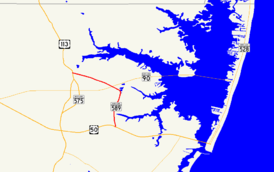
Maryland Route 589 highlighted in redRoute information Maintained by MDSHA Length: 4.65 mi[1] (7.48 km) Major junctions South end:  US 50 in Grays Corner
 MD 90 in Ocean Pines
North end: 
 US 113 / MD 575 in Showell
Location Counties: Worcester Highway system Maryland highway system
Interstate • US • State • Minor • Former • Turnpikes←  MD 588
MD 590  →
→Maryland Route 589 (MD 589) is a state highway in the U.S. state of Maryland. Known as Racetrack Road, the state highway runs 4.65 miles (7.48 km) from U.S. Route 50 (US 50) in Grays Corner north to US 113 and MD 575 in Showell. MD 589 provides access to the planned community of Ocean Pines and harness racing venue Ocean Downs, where a casino is expected to open in December 2010.[2] The first portion of the state highway was constructed through Showell in 1935. MD 589 was completed to US 50 in 1949 and 1950.
Contents
Route description
MD 589 begins at an intersection with US 50 (Ocean Gateway) in Grays Corner. The state highway immediately encounters MD 707 (Grays Corner Road), which is the old alignment of US 213 (now US 50). MD 589 heads north as a three-lane road with one lane northbound and two lanes southbound. After passing Ocean Downs, the southbound direction reduces to one lane. MD 589 crosses Taylorville Creek and passes through the hamlet of Taylorville. The state highway enters a commercial area and intersects Manklin Creek Road, which is the main access to Ocean Pines. MD 589 curves northwest, then expands to a three-lane road with center turn lane before passing another entrance to the Ocean Pines development and meeting MD 90 (Ocean City Expressway) at a diamond interchange.[1][3]
MD 589 returns to two lanes after passing Ocean Parkway, the main arterial through Ocean Pines. The state highway continues west to its junction with US 113 and MD 575, both named Worcester Highway, in Showell. The first intersection features a ramp to US 113 north and sees MD 575 head south; the ramp from US 113 north intersects MD 575 a short distance to the south. After passing under US 113, MD 589 reaches its northern terminus at West Frontage Road, which is unsigned MD 575A. Ramps from and to US 113 south are located at the northern and southern ends of MD 575A, respectively.[1][3]
History
The first section of MD 589 was constructed between US 113 and Beauchamp Road in 1935.[4][5] The state highway was extended south and east to US 50 in two segments. The first segment, from Beauchamp Road to north of Taylorville, was constructed in 1949.[6][7] The remainder of MD 589 to US 50 was completed in 1950.[7][8]
Junction list
The entire route is in Worcester County.
Location Mile
[1]Destinations Notes Grays Corner 0.00 US 50 (Ocean Gateway) – Salisbury, Ocean CitySouthern terminus 0.04  MD 707 (Grays Corner Road)
Officially MD 707B; old alignment of US 50 Ocean Pines 2.63 MD 90 (Ocean City Expressway) – Ocean City, SalisburyDiamond interchange Showell 4.56 US 113 north (Worcester Highway) / MD 575 south – Selbyville, Friendship4.65 West Frontage Road to US 113 south – Berlin Northern terminus; West Frontage Road is unsigned MD 575A 1.000 mi = 1.609 km; 1.000 km = 0.621 mi References
- ^ a b c d "Highway Location Reference: Worcester County" (PDF). Maryland State Highway Administration. 2009. http://www.marylandroads.com/Location/2009_WORCESTER.pdf. Retrieved 2010-10-25.
- ^ Cullen, Christine (2010-08-20). "Worcester County slots venue on track for December opening". Ocean City Today. http://www.oceancitytoday.net/news/2010-08-20/Top_News/Worcester_County_slots_venue_on_track_for_December.html. Retrieved 2010-10-25.
- ^ a b Google, Inc. Google Maps – Maryland Route 589 (Map). Google, Inc. http://maps.google.com/maps?f=d&source=s_d&saddr=MD-589+N%2FRace+Track+Rd&daddr=Race+Track+Rd&geocode=FVkfSQIdjgeF-w%3BFXTLSQIdwnmE-w&hl=en&mra=ls&sll=38.391169,-75.203798&sspn=0.00772,0.01929&ie=UTF8&t=h&z=13. Retrieved 2010-04-06.
- ^ Report of the State Roads Commission of Maryland. 1931-1934. Baltimore: Maryland State Roads Commission. 1934-12-28. p. 363. http://www.archive.org/details/annualreportsofs1931mary. Retrieved 2010-04-06.
- ^ Maryland Geological Survey. Map of Maryland Showing State Road System: State Aid Roads and Improved County Road Connections (Map) (1935 ed.).
- ^ Maryland State Roads Commission. Maryland: Official Highway Map (Map) (1950 ed.).
- ^ a b Report of the State Roads Commission of Maryland. 1949-1950. Baltimore: Maryland State Roads Commission. 1950-12-20. pp. 98–99. http://www.archive.org/details/annualreportsofs1949mary. Retrieved 2010-04-06.
- ^ Maryland State Roads Commission. Maryland: Official Highway Map (Map) (1951 ed.).
External links
Roads in Worcester County, Maryland State highways 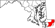
U.S. Highways Categories:- State highways in Maryland
- Roads in Worcester County, Maryland


Wikimedia Foundation. 2010.