- Mochrum
-
 Mochrum Kirk
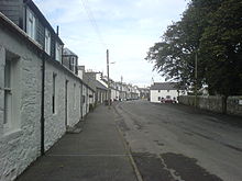 Main Street
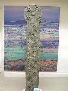 The Monrieth Cross, originally stood on the Court Hill near Mochrum, was later moved to Monreith House and finally to the Whithorn Museum.
Mochrum is a small agricultural parish in Wigtownshire on the west of the Machars peninsula, Dumfries and Galloway, Scotland. It has a population of about 125 which is considerably lower than the population of about 150 years ago. It lies 3.1 km north of the small fishing village of Port William and 14.3 km southwest of Wigtown. The parish was described by its minister in 1838 as "bleak but healthful".[1]
Village
The village consists of a Main Street, a long row of mostly large, terraced cottages dating back to the 1800s, and Mote Brae, a row of eight semi-detached formerly council-owned houses built in the early 1930s. There is evidence of another 'street' running along the line of the back gardens of the current main street houses. This may have been the original main street as the buildings found here show evidence of having been lived in (although now are almost entirely converted into sheds and garages) and are considerably older than the houses of the current Main Street). The oldest house in the village to still be in use is the old gravedigger's cottage adjacent to the kirk gates (although at this time, the author doesn't have a date for this house). The village's centrepiece is provided by the Georgian kirk building, which dates back to 1794 and is a prime example of Scotland's post-Reformation ecclesiastical architecture.[citation needed] The church is built on the site of (and using the walls of) a previous church building which dates back to the 12th Century. The former building was largely destroyed by fire in the 1770s but the current building uses most of the former building's rectangular walls in its construction. The current building was originally also rectangular in shape but was substantially altered sometime around 1840. The former Manse (the minister's residence), once provided a hotel for the village (The Green Mantle Hotel - originally opened as such in the early 1970s by Mr Don Carr) but, after changing hands when Mr Carr retired, was sold again, in the late 1990s and has unfortunately been allowed to fall into neglect. It has recently been purchased and the new owners intend it to be refurbished and used as their private residence. The village once boasted: an Inn (The George, which stood outside the main gates of the church and is now a private residence), a Hotel (The Green Mantle see above), a Post Office and grocer's shop (which is now a private residence), a school (which is now a private residence), a blacksmith's (which is now a private residence) and a joiner/undertaker's which is still in business today.
Parish
A number of farms and scattered cottages, though outside the village, come within Mochrum parish, as does the village of Port William and the clachan of Elrig. Druchtag Motehill, a steep-sided mound and site of a 12th-century motte-and-bailey castle lies about 100m north west of Mote Brae. Mochrum parish is also the site of many prehistoric forts, including the Mesolithic Barsalloch Fort, and many earthworks, standing stones, and crannógs, as well as both early and medieval crosses.[citation needed]
Notes and references
- ^ Patterson, A. & John H. Innes Watt, 1994, 'Mochrum: A Parish History, 1794-1994'
Categories:- Villages in Dumfries and Galloway


Wikimedia Foundation. 2010.