- City of Shoalhaven
-
City of Shoalhaven
New South Wales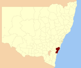
Location in NSWPopulation: 95,000(2009)[1] Area: 4568 km² (1,763.7 sq mi) Mayor: Paul Green Council Seat: Nowra (Bridge Road)[2] Region: Illawarra - South Coast State District: South Coast, Kiama Federal Division: Gilmore LGAs around City of Shoalhaven: Goulburn Mulwaree Wingecarribee Kiama Goulburn Mulwaree City of Shoalhaven Pacific Ocean Palerang Eurobodalla Pacific Ocean - "Shoalhaven" redirects here. For the river of the same name, see Shoalhaven River.
The City of Shoalhaven is a Local Government Area (population 88,405)[3] in south-eastern New South Wales (NSW), Australia, two hours south of Sydney. It is more or less conterminous with an area referred to as The Shoalhaven. It is on the Pacific Ocean and the Princes Highway and is the terminus of the South Coast line. Services are administered by the Shoalhaven City Council.[4]
Contents
History
The Shoalhaven region in New South Wales is the southern part of the traditional homelands of the Tharawal people.[5]
George Bass explored the area in 1797, following Seven Mile Beach. He crossed the shoals at the entrance to the river, calling it 'Shoals Haven' due to the shallowness of the river mouth. This river is now known as the Crookhaven,[6] but the name was adopted for the Shoalhaven area and the Shoalhaven River.
Towns
The city actually consists of a number of distinct towns that share the one government. These towns include:
- Nowra and Bomaderry;
- North of Nowra: Berry, Kangaroo Valley, Shoalhaven Heads and Jaspers Brush;
- Around Jervis Bay: Huskisson, Vincentia, Greenwell Point, Culburra Beach, Currarong, Callala Beach, Callala Bay, Orient Point, Hyams Beach, Sanctuary Point, St Georges Basin, Basin View, Falls Creek, Tomerong, Wandandian, Bream Beach, Wrights Beach;
- Further south: Sussex Inlet, Berrara, Cudmirrah, Bendalong, Cunjurong, Manyana and Lake Conjola;
- The towns of the Ulladulla area: (Ulladulla, Milton and Mollymook); and
- In the far south: Burrill Lake, Tabourie Lake, Termeil, Bawley Point and Kioloa.
 A large part of Shoalhaven can be seen from the Drawing Room Rocks area in Barren Grounds Nature Reserve. Mount Coolangatta is in the centre, with Jervis Bay in background and Berry in the right front
Currarong
Main article: CurrarongCurrarong is a small coastal fishing–tourist village in the City of Shoalhaven with a population of less than 250. The village is a haven for fishermen, with several underwater rises where fish are abundant. Currarong has a small general store, a newsagents and a cafe.
To the north of Shoalhaven is located the coastal Illawarra region and in the south on the South Coast (which are geographic, rather than administrative regions).
Culburra Beach
Main article: Culburra BeachCulburra Beach, with a population of 3,500 is the regional centre for the coastal villages east of Nowra. Originally designed by Walter Burley Griffin, the architect who designed Canberra, its shops and businesses provide a range of services and places to eat for residents and visitors to the region.
The town also boasts the two closest surf beaches to Nowra and is home to the Culburra Beach and Nowra Surf Club whose clubhouse is located at the northern end of Warrain Beach. The beaches are patrolled during the summer holiday period, and being located on either side of Penguin Head face in different directions, providing a variety of surf conditions for board riders, swimmers, body surfers and families with young children. A wide variety of fish species are caught on these beaches and from the rocky headlands adjacent to them.
Tourism
The Shoalhaven can be reached from Sydney by car via the Princes Highway and by rail via CityRail's South Coast Line which terminates just north of Nowra in Bomaderry. The most well-known part of the Shoalhaven is the Jervis Bay area. The area is approximately 160 kilometres long along the coastline, including 109 beaches, which allegedly possesses the whitest sand in the world, as well as pristine natural Australian bushland. The Shoalhaven area is home to numerous species of native Australian flora and fauna.
Culture
The area is well-known for its strong commitment to the arts and music, featuring the See Change and See Celebrations festivals in the Jervis Bay and St Georges Basin areas, as well as the EscapeArtfest festival and Blessing of the Fleet in the Ulladulla area.
Council
Shoalhaven City Council has a directly elected Mayor and 12 elected councillors representing three wards[7]:
Mayor Paul Green Ward 1 Ward 2 Ward 3 Andrew Guile David Bennett Amanda Findley Gary Kearney Bohdan Brumerskyj Robert Miller Nigel Soames John Fergusson Bob Proudfoot Gareth Ward (Deputy Mayor) Greg Watson Josi Young The Deputy Mayor is elected from among the 12 elected councillors
See also
References
- ^ Australian Bureau of Statistics (30 March 2010). "Regional Population Growth, Australia, 2008–09". http://www.abs.gov.au/ausstats/abs@.nsf/Latestproducts/3218.0Main%20Features42008-09?opendocument&tabname=Summary&prodno=3218.0&issue=2008-09&num=&view=. Retrieved 3 June 2010.
- ^ "Shoalhaven City Council". Department of Local Government. http://www.dlg.nsw.gov.au/dlg/dlghome/dlg_CouncilContactDetails.asp?slacode=6950. Retrieved 2006-11-26.
- ^ Australian Bureau of Statistics (25 October 2007). "Shoalhaven (C) (Local Government Area)". 2006 Census QuickStats. http://www.censusdata.abs.gov.au/ABSNavigation/prenav/LocationSearch?collection=Census&period=2006&areacode=LGA16950&producttype=QuickStats&breadcrumb=PL&action=401. Retrieved 2008-02-28.
- ^ http://www.shoalhaven.nsw.gov.au/default.htm Shoalhaven City Council website
- ^ Tindale Tribes, Tharawal
- ^ "Nowra Police Station". NSW Police Regions and History. Retrieved on 2008-04-29
- ^ http://www.shoalhaven.nsw.gov.au/council/councillors/index.htm
Local Government Areas of New South Wales Metropolitan Sydney Inner SydneyAshfield · Botany Bay · Burwood · Canada Bay · Canterbury · Hurstville · Kogarah · Lane Cove · Leichhardt · Manly · Marrickville · Mosman · North Sydney · Randwick · Rockdale · Strathfield · Sydney · Waverley · Willoughby · WoollahraOuter SydneyAuburn · Bankstown · Blacktown · Camden · Campbelltown · Fairfield · The Hills · Holroyd · Hornsby · Hunter's Hill · Ku-ring-gai · Liverpool · Parramatta · Penrith · Pittwater · Ryde · Sutherland · WarringahSydney SurroundsMid North Coast Bellingen · Clarence Valley · Coffs Harbour · Greater Taree · Kempsey · Nambucca · Port Macquarie-Hastings · Lord Howe IslandMurray Murrumbidgee Carrathool · Coolamon · Cootamundra · Griffith · Gundagai · Hay · Junee · Leeton · Lockhart · Murrumbidgee · Narrandera · Temora · Wagga WaggaHunter Cessnock · Dungog · Gloucester · Great Lakes · Lake Macquarie · Maitland · Muswellbrook · Newcastle · Port Stephens · Singleton · Upper HunterIllawarra Richmond Tweed Southeastern Bega · Bombala · Boorowa · Cooma-Monaro · Eurobodalla · Goulburn Mulwaree · Harden · Palerang · Queanbeyan · Snowy River · Tumut · Upper Lachlan · Yass Valley · YoungNorthern Armadale Dumaresq · Glen Innes-Severn · Gunnedah · Guyra · Gwydir · Inverell · Liverpool Plains · Moree Plains · Narrabri · Tamworth · Tenterfield · Uralla · WalchaCentral West North Western Far West Cities of New South Wales Capital: Sydney
Cities: Albury · Armidale · Bathurst · Blue Mountains · Broken Hill · Cessnock · Coffs Harbour · Dubbo · Gosford · Goulburn · Grafton · Griffith · Lake Macquarie · Lismore · Lithgow · Maitland · Newcastle · Nowra · Orange · Queanbeyan · Tamworth · Wagga Wagga · Wollongong
South Coast, New South Wales Cities: Townships: Basin View · Batehaven · Batemans Bay · Bawley Point · Bega · Bemboka · Bermagui · Berry · Bodalla · Boydtown · Broulee · Callala Bay · Candelo · Cobargo · Congo · Culburra Beach · Dalmeny · Eden · Greenwell Point · Huskisson · Hyams Beach · Kianga · Kioloa · Lake Conjola · Malua Bay · Manyana · Merimbula · Milton · Mogo · Mollymook · Moruya · Mystery Bay · Narooma · Nelligen · Nerrigundah · Pambula · Pambula Beach · Potato Point · Pyree · Rosedale · Sanctuary Point · South Durras · St Georges Basin · Tathra · Tilba · Towamba · Tura Beach · Tuross Head · Ulladulla · Vincentia · Wandandian · Wolumla · WonboynLocal Government Areas: National Parks: Ben Boyd · Bournda · Biamanga · Budawang · Clyde River · Conjola · Deua · Eurobodalla · Gulaga · Jerrawangala · Kooraban · Mimosa Rocks · Monga · Morton · Mount Imlay · Murramarang · South East Forest · WadbilligaCategories:- Local Government Areas of New South Wales
- Local Government Areas of the South Coast, New South Wales
- Cities in New South Wales
- Coastal cities in Australia
- Shoalhaven


Wikimedia Foundation. 2010.