- Northcote, New Zealand
-
Northcote 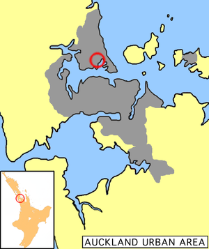
LocationBasic information Local authority North Shore City Population 4,122 (2006) Facilities Surrounds North Northcote Central East Shoal Bay Southeast (Waitemata Harbour) South Northcote Point, (Waitemata Harbour) Southwest (Waitemata Harbour) West Birkenhead Northwest Birkenhead Northcote is a suburb of North Shore City, one of several cities in the Auckland metropolitan area in northern New Zealand. It is located on the north shore of the Waitemata Harbour, four kilometres northwest of the Auckland city centre.
The suburb, which includes the peninsula of Northcote Point, includes the northern approaches to the Auckland Harbour Bridge and the culturally diverse Northcote Central shopping centre.
In 1882 the St Heliers and Northcote Land Company was formed and some land in the area was subdivided. In 1889 a major subdivision was the result when the Bartley Estate was auctioned. Before the construction of the Harbour Bridge in 1959 the Northcote Wharf was heavily utilised by the Auckland Harbour ferry service. After the Harbour bridge was built the Northcote peninsula became a quiet cul-de-sac. The wooden Northcote Tavern was once in the thick of things, it still stands but now surveys a quiet streetscape.
To the north on the main road leading to and from the Harbour Bridge is the busy Northcote Shopping Centre, which was developed in the early 1960s and has undergone continuing change during the 1970s to 1990s. It is now a multi-cultural retail hub featuring many Asian food outlets and with a mix of tenants that bears little resemblance to its first years in the 1960s.
Northcote is surrounded by the suburbs of Birkenhead, Hillcrest and Takapuna to the west and north, and the waters of Shoal Bay, an arm of the Waitemata, to the south and east.[1] State Highway 1 stretches along the waterfront of Shoal Bay, heading north from the bridge towards Albany.
The population was 4,122 in the 2006 Census, an increase of 129 from 2001.[2]
Contents
Education
Northcote College is a coeducational secondary (years 9-13) school with a decile rating of 9 and a roll of 1258.[3] It was established in 1877.[4]
During its early years, the College incorporated Standards five and six (Forms one and two) which were transferred to Northcote Intermediate School when that was established as a separate entity on its present site in Lake Road in 1958. Northcote Intermediate has now celebrated 50 years as a separate school. Close by to the Intermediate is Onepoto Primary School, which serves the central Northcote area.
Northcote Primary School is a coeducational contributing primary (years 1-6) school with a decile rating of 9 and a roll of 377.[5] It was established on its present site in 1918.[6] The Northcote area war memorial stands at the front of the school, on the corner of Lake and Onewa Roads.
St Mary's School is a primary school with a decile rating of 7 and a roll of 402.[7] It is a state integrated Catholic school, which provides education for both boys and girls in years 1-6, and for girls only in years 7-8.[8] It celebrated its 75th Jubilee in 2008.[9]
The North Shore campus of AUT University is located on Akoranga Drive, Northcote.
See also
References
- The Heart of Colonial Auckland, 1865-1910. Terence Hodgson. Random Century NZ Ltd 1992.
- ^ http://www.northshorecity.govt.nz/Suburbs/PDFs/SuburbSearch/city_web_suburb.pdf
- ^ The statistical area corresponding to Northcote is called "Northcote South". Quickstats about Northcote South
- ^ Te Kete Ipurangi schools database: Northcote College
- ^ "Celebrating 131 Years of Excellence". Northcote College. Archived from the original on 2008-08-04. http://web.archive.org/web/20080804113530/http://www.northcote.school.nz/about+us/about_us.php. Retrieved 2009-01-27.
- ^ Te Kete Ipurangi schools database: Northcote School
- ^ "Our School". Northcote School. http://www.northcoteprimary.school.nz/main/index.php. Retrieved 2009-01-27.
- ^ Te Kete Ipurangi schools database: St Mary's School
- ^ "About Us". St Mary's School. http://www.stmarys-school.ac.nz/main.cfm?id=898. Retrieved 2009-01-27.
- ^ "75th Jubilee 2008". St Mary's School. http://www.stmarys-school.ac.nz/main.cfm?id=8316. Retrieved 2009-01-27.
External links
Categories:

Wikimedia Foundation. 2010.