- Delaware Route 62
-
Delaware Route 62
Route information Maintained by DelDOT Length: 2.65 mi[1] (4.26 km) Major junctions West end: 
 DE 2 / DE 41 in Prices Corner
 DE 141 near Prices Corner
 DE 4 near Newport
East end: Dead end in Newport Highway system ←  DE 58
DE 58DE 71  →
→Delaware Route 62 (DE 62) is a state highway in New Castle County, Delaware. The route officially runs from Delaware Route 2 and Delaware Route 41 in Prices Corner east to a dead end near Newport; however, DE 62 signage ends at the Delaware Route 4 intersection. The road runs through suburban areas along Newport Gap Pike and Boxwood Road, interchanging with Delaware Route 141. The Newport Gap Pike portion of road was built as a state highway by 1925 and became part of DE 41 by 1936. DE 62 was assigned to its current alignment by 1981.
Contents
Route description
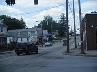 DE 62 (Newport Gap Pike) westbound at Old Capitol Trail.
Delaware Route 62 heads southeast from Delaware Route 2 (Kirkwood Highway) on the Newport Gap Pike. At this intersection, DE 41 continues north on Newport Gap Pike and east on DE 2. DE 62 follows the Newport Gap Pike through suburban developments and across CSX's Philadelphia Subdivision to Boxwood Road, where it turns to the east. Immediately after turning onto Boxwood Road, it features an interchange with Delaware Route 141. DE 62 then heads east, passing to the south of the former Wilmington Assembly plant used by General Motors, and continues into suburban neighborhoods. It reaches an intersection with Delaware Route 4, where DE 62 signage ends. The route officially continues east on Middleboro Road, intersecting Dupont Road before a dead end.[1][2]
History
By 1920, what is now DE 62 existed as a county road.[3] The Newport Gap Pike portion of the route became a state highway by 1925.[4] This state highway became a part of DE 41 by 1936, when Delaware designated its state highways.[5] By 1981, DE 62 was designated onto its current alignment, with the Newport Gap Pike section replacing a portion of DE 41.[6]
Major intersections
The entire route is in New Castle County.
Location Mile[1] Road Notes Prices Corner 0.00 DE 2 / DE 41 (Kirkwood Highway/Newport Gap Pike)Western terminus Newport 0.73 DE 141Interchange 1.92 DE 4 (Newport Pike/Maryland Avenue)Eastern terminus of DE 62 signage 2.65 Dead end Eastern terminus 1.000 mi = 1.609 km; 1.000 km = 0.621 mi See also
 U.S. Roads portal
 Delaware portal
References
- ^ a b c http://www.deldot.gov/information/pubs_forms/manuals/traffic_counts/2006/pdf/rpt_pgs1_38_rev.pdf DelDOT 2006 Traffic Count and Mileage Report
- ^ Google, Inc. Google Maps – overview of Delaware Route 62 (Map). Cartography by Google, Inc. http://maps.google.com/maps?f=d&source=s_d&saddr=delaware+2+and+newport+gap+pike&daddr=39.725645,-75.616575+to:middleboro+road+and+dupont+road&geocode=FdRSXgIdb_h9-ymT1qpu_QHHiTGgOoY8TYh2ZQ%3BFU0qXgIdwS5--yl72jNIAwLHiTHXGlms-89ZVg%3BFVobXgIdNat--ymtUOq5egLHiTGoCE_SBQnlbA&hl=en&mra=ls&sll=39.73065,-75.607335&sspn=0.028384,0.084543&ie=UTF8&t=h&z=14&via=1. Retrieved 2010-09-04.
- ^ Delaware Department of Transportation (PDF). Delaware Official Highway Map (Map) (1920 ed.). http://www.deldot.gov/archaeology/historic_pres/historic_highway_maps/pdf/cd_002.pdf. Retrieved 2010-04-15.
- ^ Delaware Department of Transportation (PDF). Delaware Official Highway Map (Map) (1925 ed.). http://www.deldot.gov/archaeology/historic_pres/historic_highway_maps/pdf/cd_004.pdf. Retrieved 2010-08-19.
- ^ Delaware Department of Transportation (PDF). Delaware Official Highway Map (Map) (1936/37 ed.). http://www.deldot.gov/archaeology/historic_pres/historic_highway_maps/pdf/cd_008.pdf. Retrieved 2010-04-15.
- ^ Delaware Department of Transportation (PDF). Delaware Official Highway Map (Map) (1981 ed.). http://www.deldot.gov/archaeology/historic_pres/historic_highway_maps/pdf/cd_058.pdf. Retrieved 2010-08-19.
Categories:- State highways in Delaware
- Transportation in New Castle County, Delaware


Wikimedia Foundation. 2010.