- Myōjin-shō
-
Myōjin-shō 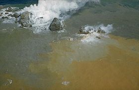
Steam pours from the blocky summit of a lava dome formed at Myōjin-shō during a submarine eruption at the Bayonnaise Rocks volcano in 1952.Elevation -50 m (-164 ft) Location Location Izu Islands, Japan Coordinates 31°55.1′N 140°1.3′E / 31.9183°N 140.0217°ECoordinates: 31°55.1′N 140°1.3′E / 31.9183°N 140.0217°E Geology Type lava dome Last eruption 1970 Myōjin-Shō (ja:明神礁 みょうじんしょう) is a submarine volcano located about 450 kilometers south of Tokyo on the Izu-Ogasawara Ridge in the Izu Islands. Volcanic activity has been detected there since 1869. Since then it has undergone more eruptions, the most powerful of which resulted in the appearance and disappearance of a small island.
The name Myōjin-Shō derives from a fishing boat, No.11 Myōjin-Maru of Yaizu City, Shizuoka Prefecture, the crew of which first witnessed the major volcanic eruption of 1952.
Contents
Eruption of 1952-3
The volcanic eruption from 1952 to 1953 was one of its biggest activities on record, with the repetitious appearance and disappearance of an island, which at one point reached over ten metres above sea level, before sinking after a severe volcanic explosion in September 1953. On September 24, 1953, a survey vessel, No. 5 Kaiyo-Maru of the Hydrographic Department of the Maritime Safety Agency, was destroyed by the volcano, with the loss of its crew of 31 (including the nine scientists studying the eruption). Consequently the Department developed Manbou (Sunfish), an unmanned radio operating survey boat, and has used it for the research of dangerous sea areas such as submarine volcanoes.
This was the first time that volcanic activity had been detected using the SOFAR channel.[1]
Survey of 1998-9
In 1998 and 1999, the Hydrography Department conducted comprehensive sea bottom surveys around Myōjin-Shō, using the state-of-the-art survey vessel Shoyo and Manbou II, the second generation Manbou. As a result of these surveys, a detailed picture of the sea bottom topography around Myōjin-Shō was made for the first time.
Manbou II conducted the survey of the sea area within a radius of 3 nautical miles (about 5.4 kilometers) of Myōjin-Shō. Shoyo conducted the survey of the sea area within a radius of about 10 nautical miles (about 18.5 kilometers) but farther than the area of the radius of 3 nautical miles (5.6 km). Manbou II works by the order of preprogrammed instructions and measures depth and water temperature. Bathymetric survey of Manbou II was carried out by using the "PRD-601" echo sounder at intervals of 0.2 nautical miles (about 370 meters). Shoyo conducted a comprehensive survey including the geological and geophysical surveys of sea bottom. Bathymetric survey of Shoyo was carried out by using a "Seabeam 2112" echo sounder at intervals of 0.5 nautical miles (about 930 meters).
Structure
Previously, Myōjin-Shō was considered to be the central cone of a double volcano with the Bayonnaise Rocks (rocks of 9.9 meters in height above the sea level) as a portion of the somma (Mita, 1949). As a result of the survey, however, the authors found that both Myōjin-Shō and the Bayonnaise Rocks are cones on the somma of a double volcano. The foot of this double volcano lies 1,400 to 1,500 meters in depth and the size is about 30 by 25 kilometers east-west, north-south. The somma is almost a circle in the diameter of 7 by 9 kilometers and the height is 1,000 – 1,400meters.
The diameter of the caldera floor is 5.6 kilometers and about 1,100 meters in depth. The central cone is a high formerly known as Takane-Sho, 328 metres below sea level.
Myōjin-Shō is a post caldera cone formed in the northeastern part of the somma of the double volcano. It is the single conical cone and the height is 550 meters with the shallowest depth 50 meters. A record that suggests a gushing of bubbles near the summit was obtained and the micro earthquake were observed near the Myōjin-Shō, showing that the volcano is still active, although at a low level.
References
- ^ http://www.gsajournals.org/perlserv/?request=get-abstract&doi=10.1130%2F0016-7606(1954)65%5B941%3ATDOMVE%5D2.0.CO%3B2 "Transpacific detection of Myojin volcanic explosions by underwater sound"
External links
- Survey of Myojin-sho
- "Bayonnaise Rocks". Global Volcanism Program, Smithsonian Institution. http://www.volcano.si.edu/world/volcano.cfm?vnum=0804-07=.
Categories:- Izu-Bonin volcanic arc
- Submarine volcanoes
- Seamounts of the Pacific Ocean
- New islands
- Former islands
- Natural disasters in Japan
- 1952 natural disasters
- Postwar Japan

Wikimedia Foundation. 2010.