- Mason County, Kentucky
-
Mason County, Kentucky 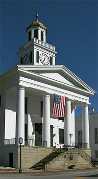 The "Old" Mason County courthouse in Maysville, Kentucky
Location in the state of Kentucky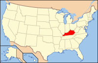
Kentucky's location in the U.S.Founded 1789 Named for George Mason (1725–1792), American revolutionary, patriot and founding father. Seat Maysville Area
- Total
- Land
- Water
246.60 sq mi (639 km²)
241.11 sq mi (624 km²)
5.49 sq mi (14 km²), 2.23%Population
- (2000)
- Density
16,800
70/sq mi (27/km²)Time zone Eastern: UTC-5/-4 Website www.masoncountykentucky.com Mason County is a county located in the U.S. state of Kentucky. As of 2000, the population was 16,800. Its county seat is Maysville[1]. The county is named for George Mason, a Virginia delegate to the U.S. Constitutional Convention, known as the "Father of the Bill of Rights". Mason County was partitioned from Bourbon County, Kentucky, in 1788.
Mason County is part of the Maysville Micropolitan Statistical Area.
Contents
Geography
According to the 2000 census, the county has a total area of 246.60 square miles (638.7 km2), of which 241.11 square miles (624.5 km2) (or 97.77%) is land and 5.49 square miles (14.2 km2) (or 2.23%) is water.[2]
Adjacent counties
- Brown County, Ohio (north, across the Ohio River)
- Adams County, Ohio (northeast, across the Ohio River)
- Lewis County (east)
- Fleming County (south)
- Robertson County (southwest)
- Bracken County (west)
Demographics
Historical populations Census Pop. %± 1790 2,729 — 1800 12,182 346.4% 1810 12,459 2.3% 1820 13,588 9.1% 1830 16,199 19.2% 1840 15,719 −3.0% 1850 18,344 16.7% 1860 18,222 −0.7% 1870 18,126 −0.5% 1880 20,469 12.9% 1890 20,773 1.5% 1900 20,446 −1.6% 1910 18,611 −9.0% 1920 17,760 −4.6% 1930 18,862 6.2% 1940 19,066 1.1% 1950 18,486 −3.0% 1960 18,454 −0.2% 1970 17,273 −6.4% 1980 17,765 2.8% 1990 16,666 −6.2% 2000 16,800 0.8% http://ukcc.uky.edu/~census/21161.txt As of the census[3] of 2000, there were 16,800 people, 6,847 households, and 4,697 families residing in the county. The population density was 70 per square mile (27 /km2). There were 7,754 housing units at an average density of 32 per square mile (12 /km2). The racial makeup of the county was 90.88% White, 7.16% Black or African American, 0.15% Native American, 0.37% Asian, 0.02% Pacific Islander, 0.57% from other races, and 0.85% from two or more races. 0.95% of the population were Hispanic or Latino of any race.
There were 6,847 households out of which 31.30% had children under the age of 18 living with them, 54.20% were married couples living together, 11.10% had a female householder with no husband present, and 31.40% were non-families. 27.60% of all households were made up of individuals and 12.80% had someone living alone who was 65 years of age or older. The average household size was 2.41 and the average family size was 2.92.
In the county the population was spread out with 24.10% under the age of 18, 8.00% from 18 to 24, 28.50% from 25 to 44, 23.90% from 45 to 64, and 15.50% who were 65 years of age or older. The median age was 38 years. For every 100 females there were 93.70 males. For every 100 females age 18 and over, there were 89.50 males.
The median income for a household in the county was $30,195, and the median income for a family was $37,257. Males had a median income of $30,718 versus $21,216 for females. The per capita income for the county was $16,589. About 12.90% of families and 16.80% of the population were below the poverty line, including 23.60% of those under age 18 and 13.70% of those age 65 or over.
Cities, towns, and communities
See also
References
- ^ "Find a County". National Association of Counties. http://www.naco.org/Counties/Pages/FindACounty.aspx. Retrieved 2011-06-07.
- ^ "Census 2000 U.S. Gazetteer Files: Counties". United States Census. http://www.census.gov/tiger/tms/gazetteer/county2k.txt. Retrieved 2011-02-13.
- ^ "American FactFinder". United States Census Bureau. http://factfinder.census.gov. Retrieved 2008-01-31.
External links
- Mason County government's website
- Historical Texts and Images of Mason County
- Mason County school district's website
Municipalities and communities of Mason County, Kentucky Cities Dover | Germantown | Maysville | Sardis
Unincorporated
communitiesCategories:- Kentucky counties
- Mason County, Kentucky
- Ohio River counties
- Maysville micropolitan area


Wikimedia Foundation. 2010.