- Menifee County, Kentucky
-
Menifee County, Kentucky 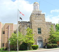 Menifee County courthouse in Frenchburg, Kentucky
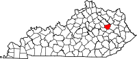
Location in the state of Kentucky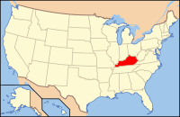
Kentucky's location in the U.S.Founded 1869 Named for Richard H. Menefee, United States Congressman (1837–1839) Seat Frenchburg Area
- Total
- Land
- Water
206.03 sq mi (534 km²)
203.90 sq mi (528 km²)
2.13 sq mi (6 km²), 1.03%Population
- (2000)
- Density
6,556
32/sq mi (12/km²)Time zone Eastern: UTC-5/-4 Website www.frenchburgmenifee.org Menifee County is a county located in the U.S. state of Kentucky. As of 2000, the population was 6,556. Its county seat is Frenchburg[1]. The county is named for Richard Hickman Menefee, U.S. Congressman, although the spelling has changed. It is a prohibition or dry county.
Menifee County is located in the foothills of the Cumberland Plateau.[2] It is part of the Mount Sterling Micropolitan Statistical Area.
Contents
History
Menifee County was formed on May 29, 1869, from portions of Bath, Montgomery, Morgan, Powell, and Wolfe counties.[2]
In the 2008 Presidential Election Menifee County was one of eight in the state of Kentucky where the majority of voters voted for Barack Obama.[3]
Geography
According to the 2000 census, the county has a total area of 206.03 square miles (533.6 km2), of which 203.90 square miles (528.1 km2) (or 98.97%) is land and 2.13 square miles (5.5 km2) (or 1.03%) is water.[4]
Menifee County is mountainous and heavily forested. Much of the land is within Daniel Boone National Forest. Only about 10% of the county's land is in cultivated farms, and the county ranks 102nd of Kentucky's 120 counties in agricultural revenue.[2]
Adjacent counties
- Bath County (north)
- Rowan County (northeast)
- Morgan County (east)
- Wolfe County (south)
- Powell County (southwest)
- Montgomery County (west)
National protected area
- Daniel Boone National Forest (part)
Demographics
Historical populations Census Pop. %± 1870 1,986 — 1880 3,755 89.1% 1890 4,666 24.3% 1900 6,818 46.1% 1910 6,153 −9.8% 1920 5,779 −6.1% 1930 4,958 −14.2% 1940 5,691 14.8% 1950 4,798 −15.7% 1960 4,276 −10.9% 1970 4,050 −5.3% 1980 5,117 26.3% 1990 5,092 −0.5% 2000 6,556 28.8% http://ukcc.uky.edu/~census/21165.txt As of the census[5] of 2000, there were 6,556 people, 2,537 households, and 1,900 families residing in the county. The population density was 32 per square mile (12 /km2). There were 3,710 housing units at an average density of 18 per square mile (6.9 /km2). The racial makeup of the county was 97.64% White, 1.37% Black or African American, 0.12% Native American, 0.03% Asian, 0.02% Pacific Islander, 0.14% from other races, and 0.69% from two or more races. 1.11% of the population were Hispanic or Latino of any race.
There were 2,537 households out of which 32.00% had children under the age of 18 living with them, 62.40% were married couples living together, 8.80% had a female householder with no husband present, and 25.10% were non-families. 22.10% of all households were made up of individuals and 9.10% had someone living alone who was 65 years of age or older. The average household size was 2.49 and the average family size was 2.88.
In the county the population was spread out with 24.90% under the age of 18, 10.10% from 18 to 24, 28.10% from 25 to 44, 25.20% from 45 to 64, and 11.80% who were 65 years of age or older. The median age was 36 years. For every 100 females there were 101.80 males. For every 100 females age 18 and over, there were 98.10 males.
The median income for a household in the county was $22,064, and the median income for a family was $26,325. Males had a median income of $25,670 versus $17,014 for females. The per capita income for the county was $11,399. About 23.40% of families and 29.60% of the population were below the poverty line, including 38.50% of those under age 18 and 23.40% of those age 65 or over.
Cities and towns
See also
References
- ^ "Find a County". National Association of Counties. http://www.naco.org/Counties/Pages/FindACounty.aspx. Retrieved 2011-06-07.
- ^ a b c Bryant, Ron D. (1992). "Menifee County". In Kleber, John. Encyclopedia of Kentucky. pp. 625.
- ^ Officials in 4 Appalachian counties proud their residents supported Obama Lexington Herald-Leader, Nov 6, 2008.
- ^ "Census 2000 U.S. Gazetteer Files: Counties". United States Census. http://www.census.gov/tiger/tms/gazetteer/county2k.txt. Retrieved 2011-02-13.
- ^ "American FactFinder". United States Census Bureau. http://factfinder.census.gov. Retrieved 2008-01-31.
External links
Municipalities and communities of Menifee County, Kentucky City Unincorporated
communitiesDenniston | Korea | Mariba | Means | Pomeroyton | Scranton | Sudith | Wellington
Eastern Mountain Coal Fields Counties Cities and towns
10k-25kCities and towns
5k-10kCities and towns
1k-5kBarbourville • Beattyville • Catlettsburg • Clay City • Cumberland • Elkhorn City • Evarts • Grayson • Greenup • Harlan • Hazard • Jackson • Jeffersonville • Jenkins • Louisa • Manchester • Olive Hill • Paintsville • Pineville • Prestonsburg • Raceland • Russell • Salyersville • South Shore • Stanton • West Liberty • Wheelwright • Whitesburg • Worthington • WurtlandCities and towns
under 1kAllen • Bellefonte • Benham • Blackey • Blaine • Booneville • Buckhorn • Camargo • Campton • Cedarville • Coal Run Village • Fleming-Neon • Frenchburg • Hindman • Hyden • Inez • Lakeview Heights • Loyall • Lynch • Martin • McKee • Pippa Passes • Sandy Hook • Vicco • Wallins Creek • Warfield • WaylandStatistical areas Categories:- Kentucky counties
- Menifee County, Kentucky
- Dry counties of Kentucky
- Mount Sterling micropolitan area


Wikimedia Foundation. 2010.