- Upminster
-
Coordinates: 51°33′21″N 0°15′04″E / 51.555743°N 0.251239°E
Upminster 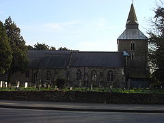
St Lawrence Church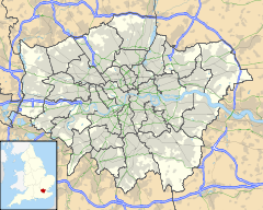
 Upminster
Upminster shown within Greater LondonPopulation 25,441 (Cranham and Upminster wards 2007)[1] OS grid reference TQ560865 - Charing Cross 16.5 mi (26.6 km) WSW London borough Havering Ceremonial county Greater London Region London Country England Sovereign state United Kingdom Post town UPMINSTER Postcode district RM14 Dialling code 01708 Police Metropolitan Fire London Ambulance London EU Parliament London UK Parliament Hornchurch and Upminster London Assembly Havering and Redbridge List of places: UK • England • London Upminster is a suburban town in northeast London, England, and part of the London Borough of Havering.[2] Located 16.5 miles (26.6 km) east-northeast of Charing Cross, it is one of the locally important district centres identified in the London Plan,[2] and comprises a number of shopping streets and a large residential area. It was historically a rural village in the county of Essex and formed an ancient parish.[3] Although peripheral to London, the town has good transport links; it was first connected to central London by rail in 1885[3] and has a station on the London Underground network.[4] The economic history of Upminster is characterised by a shift from farming to garden suburb.[3] As part of the suburban growth of London in the 20th century, Upminster significantly expanded and increased in population, becoming part of Hornchurch Urban District in 1934, and has formed part of Greater London since 1965.[5]
Contents
History
Toponymy
Upminster (parish) population 1881 1,202 1891 1,409 1901 1,477 1911 2,468 1921 3,559 1931 5,732 1941 war # 1951 13,038 # no census was held due to war source: UK census[6] The placename Upminster is first recorded in 1062 as Upmynstre and is recorded in the 1086 Domesday Book as Upmunstra.[7] It is formed from Old English upp and mynster, meaning the large church on high ground. The high ground of the parish church being in relation to the valley of the River Ingrebourne and the Upminster Bridge over the river shares the name.[7] An alternative explanation suggests the upp could refer to the geographical relationship to a church at Barking or Tilbury in Anglo-saxon times (cf. Southminster and Bradwell-juxta-Mare).[8]
Economic development
There was an ancient farmstead from the 1st century to the 3rd century in the Upminster area, and agriculture was the predominant industry throughout the following centuries.[3] The area was once wooded, but clearances in the 12th century gave more land over to arable farming; and by the 17th century there were a variety of crops and livestock.[3] There was a growth in market gardening in the 19th century.[3] There have been a number of windmills in Upminster and one of which, a smock mill built in 1803, remains.[9] Local industry included a tannery, gravel extraction and a brick works that was connected to the railway station by a tramway in 1895.[3]
The London, Tilbury and Southend Railway from Fenchurch Street was extended from Barking to Upminster in 1885.[10] The underground Whitechapel and Bow Railway opened in 1902 and allowed through services of the Metropolitan District Railway to operate to Upminster. The Metropolitan District converted to electric trains in 1905 and services were cut back to East Ham. Delayed by World War I,[10] electrified tracks were extended by the London, Midland and Scottish Railway to Upminster and through services resumed in 1932.[11][12]
Local government
 1931: Upminster (4) within Romford Rural District, adjoining Great Warley (3), Cranham (5) and Rainham (6)
Upminster formed an ancient parish of 3,369 acres (1,363 ha) in the Chafford hundred of Essex.[3] The parish vestry had meetings in the church until 1798, when they moved to the Bell Inn.[5] The parish was divided into North and South wards by the Hornchurch to Cranham road.[5] In 1836 the vestry lost control of poor relief, with Upminster becoming part of the Romford Poor Law Union[5] and in 1875 the parish became part of Romford rural sanitary district. Following the Local Government Act 1894, the sanitary district became Romford Rural District and a parish council was formed of nine members, increasing to twelve by 1913 as the population had doubled.[5] The parish council acquired the Clock House building on St Mary's Lane for use as offices in 1924.[5] The parish formed part of the London Traffic Area from 1924 and the London Passenger Transport Area from 1933.[13] In 1934 the parish council was abolished and Upminster was combined with other parishes to form part of Hornchurch Urban District. In 1965 the urban district was abolished and its former area was combined with that of Municipal Borough of Romford; and since then has formed part of the London Borough of Havering in Greater London.[14]
Urban development
The parish had three early centres of activity; the village around the church and the settlements of Hacton and Corbets Tey.[3] The estates of Gaynes, New Place and Upminster Hall were purchased during the 17th century by merchants in the City of London.[3] This caused a significant number of buildings in the town to be constructed or improved.[3] Upkeep of the three bridges crossing the Ingrebourne were the responsibility of Upminster, as the adjacent Hornchurch parish was in the Havering liberty and was exempt from responsibility because of its charter. Although the opening of the station was key to the development of the suburb, land was not purchased for development until 10 acres (4.0 ha) were secured in 1901.[3]
Electricity was introduced in Upminster in 1926.[5] Gas main supply came from Romford in 1872 and from 1905 there was gas street lighting.[5] The area was served by good spring water, with mains supply provided by the South Essex Waterworks Company from 1836. Works on the sewerage system began in 1899 in Upminster village and Corbets Tey. In 1922 sewage works for Upminster and Cranham were opened in Great Warley.[5] Land for Upminster Park was purchased by the parish council in 1929.
Speed of sound
The speed of sound was first accurately calculated in Upminster. The Reverend William Derham, Rector of Upminster, used a telescope from the tower of the church of St Laurence, Upminster to observe the flash of a distant shotgun being fired, and then measured the time until he heard the gunshot, and subsequently the distance the sound had travelled.
Governance
 Hornchurch and Upminster constituency in Greater London
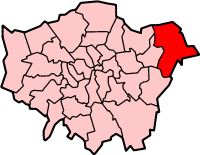
The town forms part of the Hornchurch and Upminster UK Parliament constituency, and is covered by the Havering wards of Upminster and Cranham. The current MP is Angela Watkinson. Each ward elects three councillors to Havering London Borough Council. All six councillors elected in 2010 for the two wards were the Upminster and Cranham Residents' Association candidates[15][16] and the area is unusual in that the residents' association is strongly active.[17] From 1945 to 1974 Upminster formed part of the Hornchurch constituency and from 1974 to 2010 it formed part of the Upminster constituency. Upminster is within the Havering and Redbridge London Assembly constituency and the London European Parliament constituency.[17]
Geography
Further information: Geography of London Map of Upminster and environs
Upminster rises to about 200 feet (61 m) above sea level to the north and is about 50 feet (15 m) above sea level to the south.[3] It rests on a layer of loam, above sand and gravel in the south and London Clay to the north. It is bounded in the west by the River Ingrebourne and there is a stream running east-west, just north of Corbets Tey that has been dammed to form a lake.[3] It has formed part of the continuously built-up area of London since the 1930s[18] and is contiguous with Cranham to the east and Hornchurch to the west. To the north and south there is open land that forms part of the Metropolitan Green Belt and there are open spaces formed by Upminster Golf Club and Upminster Hall Playing Field to the north, Upminster Park and Clock House Gardens to the south, and the Ingrebourne Valley linear park to the south west. The town is effectively divided into north and south parts by the railway line. The north is predominantly residential, with the southern part containing the main shopping area. Further south it becomes predominantly residential again. Upminster is a post town in the RM postcode area; it forms a long protrusion over the M25 motorway and additionally includes North Ockendon, also in Havering, and Bulphan in Thurrock.[19]
Demography
Upminster compared (2001 Census) Statistic Upminster[20] Cranham[21] Havering[20] London[20] England[20] Ethnic group White 12,354 11,930 213,421 5,103,203 44,679,361 Asian 133 120 4,088 866,693 2,248,289 Black 59 64 3,139 782,849 1,132,508 Mixed 87 78 2,298 226,111 643,373 Chinese/Other 41 19 827 70,928 231,424 Population Total 12,674 12,242 224,248 7,172,091 49,138,831 Density(/hectare) 5.62 18.67 19.97 45.62 3.77 Households 4,946 5,111 91,722 3,015,997 20,451,427 The Havering committee area for Upminster is defined as the wards of Upminster and Cranham.[22] Demographic data is produced by the Office for National Statistics for these wards. All of Upminster is contained within these wards, however they also cover the connected settlement of Cranham and the rural outlier of North Ockendon. In 2001 the population of Upminster ward was 12,674[20] and Cranham ward was 12,242,[21] giving a total population of 25,098. 80.95% in Upminster and 81.73% in Cranham report their religion as Christian, compared to 76.13% for Havering, 58.23% in London and 71.74% in England. 10.08% in Upminster and 10.46% in Cranham report having no religion, compared to 13.18% in Havering, 15.76% in London and 14.59% in England.[20][21] With a black and minority ethnic population of 3% in 2001, Cranham and Upminster wards have the lowest Simpson index for ethnic diversity in London.[23] The level of home ownership is atypically high compared to the rest of London and England, with over 90% of housing tenure under owner-occupation in both wards.[24][25]
Economy
Upminster is identified in the London Plan as a local district centre with 37,000 square metres (400,000 sq ft) of commercial floorspace.[2] It is not considered a significant commercial office location.[2] Within Havering, it is identified as one of seven town centres in the borough,[26] with a retail area extending along Station Road, St Mary's Lane and Corbets Tey Road.[27]
Transport
Further information: Transport in London and Public transport in Havering Upminster station southern entrance, there is another to the west
The town is served by Upminster station on the London-Tilbury-Southend Line and the London Underground, in London fare zone 6.[4] The western part of the town is also served by Upminster Bridge tube station. Upminster and Upminster Bridge are on the District line of the London Underground, with services to Richmond, Ealing Broadway and Wimbledon via central London. The station at Upminster is served by National Rail operators c2c and National Express East Anglia, with services to Fenchurch Street via West Ham; Shoeburyness via Basildon; Southend via Chafford Hundred;[28] and Romford via Emerson Park.[29] There are Transport for London bus services to Hornchurch, Romford, North Ockendon, Lakeside Shopping Centre and Cranham.[30] To the south of Upminster is Damyns Hall Aerodrome. The A127 road to the north is the main radial artery to central London, with the A124 road terminating in the town. The M25 motorway is located about 1.5 miles (2.4 km) to the east of the town centre.
Culture
 Upminster Windmill is located in a small open space called Windmill Field
Havering Council's urban strategy recognises that nearby Hornchurch is the main cultural hub of the borough with a large theatre and arts spaces, and Romford offers the largest regional concentration of entertainment facilities.[31] Within Upminster is New Windmill Hall, a flexible entertainment space, built in 1968, which holds up to 300 people.[32] Upminster forms part of the tourism strategy for the borough.[33] It is the location of Upminster Windmill, one of the few remaining mills in Greater London and is Grade II* listed.[34] There is also the Tithe Barn Museum, containing artifacts of domestic and agricultural use. In the west of Upminster is Hornchurch Stadium, which is the home ground of A.F.C. Hornchurch. Upminster is often associated with Ian Dury and his 1981 album Lord Upminster is named after the town.[35]
See also
References
- ^ "Mid-2007 Population Estimates for 2007 Wards in England". Office for National Statistics. 2009. http://www.statistics.gov.uk/statbase/Product.asp?vlnk=13893. Retrieved 8 February 2010.
- ^ a b c d Mayor of London (May 2006). "The London Plan: East London Sub Regional Development Framework". Greater London Authority. http://www.london.gov.uk/archive/mayor/planning/srdf/docs/east-srdf.pdf. Retrieved 6 February 2010.
- ^ a b c d e f g h i j k l m n Powell, W.R. (Edr.) (1978). Upminster: Introduction and manors, A History of the County of Essex: Volume 7. Victoria County History. British History Online. http://www.british-history.ac.uk/report.aspx?compid=42829. Retrieved 6 February 2010.
- ^ a b Transport for London (March 2009). "High frequency services". Greater London Authority. http://www.tfl.gov.uk/assets/downloads/high-frequency-services-map.pdf. Retrieved 6 February 2010.
- ^ a b c d e f g h i Powell, W.R. (Edr.) (1978). Upminster: Local government and parliamentary representation, A History of the County of Essex: Volume 7. Victoria County History. British History Online. http://www.british-history.ac.uk/report.aspx?compid=42830. Retrieved 6 February 2010.
- ^ Vision of Britain - Upminster population. Retrieved on 6 February 2010.
- ^ a b Mills, D. (2000). Oxford Dictionary of London Place Names. Oxford.
- ^ Blair, John (2005). The Church in Anglo-Saxon Society. Oxford University Press. p. 102.
- ^ Richardson, John (2000). The Annuls of London. Cassell & Co. ISBN 184188135X.
- ^ a b "London, Tilbury and Southend Railway", Local Studies Information Sheets (Barking and Dagenham London Borough Council), 2008, http://www.barking-dagenham.gov.uk/4-heritage/local-history/information-sheets/pdf/info-sheet-10.pdf, retrieved 8 February 2010
- ^ Rose, Douglas (1999). The London Underground: A diagrammatic history (7 ed.). Douglas Rose. ISBN 1854142194.
- ^ Wolmar, Christian (2005). The Subterranean Railway: How the London Underground Was Built and How It Changed the City Forever. Atlantic Books. p. 268. ISBN 1-84354-023-1.
- ^ Robson, William (1939). The Government and Mis-government of London. London: Allen & Unwin.
- ^ Vision of Britain - Havering London Borough. Retrieved on 6 February 2010.
- ^ "Cranham Ward - Local election results 2010". Havering London Borough Council. 8 June 2010. http://www.havering.gov.uk/index.aspx?articleid=18029. Retrieved 4 July 2010.
- ^ "Upminster Ward - Local election results 2010". Havering London Borough Council. 8 June 2010. http://www.havering.gov.uk/index.aspx?articleid=18045. Retrieved 4 July 2010.
- ^ a b Baston, Lewis (8 February 2008). "Havering and Redbridge". guardian.co.uk. http://www.guardian.co.uk/politics/2008/feb/08/havering.redbridge. Retrieved 20 February 2010.
- ^ Robson, William (1939). The Government and Mis-government of London. London: Allen & Unwin. pp. 26–27.
- ^ Royal Mail (2004). Address Management Guide (4 ed.). Royal Mail Group. p. 168.
- ^ a b c d e f Neighbourhood Statistics (2001). "2001 Census: Census Area Statistics, Area: Upminster (Ward)". Office for National Statistics. http://www.neighbourhood.statistics.gov.uk/dissemination/LeadAreaSearch.do?a=7&c=romford+town&d=14&r=1&i=1001&m=0&s=1250418652857&enc=1&areaSearchText=upminster&areaSearchType=14&extendedList=false&searchAreas=. Retrieved 6 February 2010.
- ^ a b c Neighbourhood Statistics (2001). "2001 Census: Census Area Statistics, Area: Cranham (Ward)". Office for National Statistics. http://www.neighbourhood.statistics.gov.uk/dissemination/LeadDatasetList.do?a=7&b=6096871&c=cranham&d=14&g=336496&i=1001x1003&m=0&r=1&s=1250418744778&enc=1&domainId=16. Retrieved 6 February 2010.
- ^ Upminster Area Committee (June 2009). "Upminster Area Committee (Cranham & Upminster Wards) Agenda". Havering London Borough Council. http://www.havering.gov.uk/CHttpHandler.ashx?id=18289&p=0. Retrieved 6 February 2010.
- ^ Piggott, Gareth (January 2006). "Simpson's diversity indices by ward 1991 and 2001". Data Management and Analysis Group. Greater London Authority. http://www.london.gov.uk/archive/gla/publications/factsandfigures/dmag-briefing-2006-2.pdf. Retrieved 8 February 2010.
- ^ "Area: Upminster (Ward): Tenure (KS18)". Neighbourhood Statistics. Office for National Statistics. 9 November 2004. http://www.neighbourhood.statistics.gov.uk/dissemination/LeadTableView.do?a=7&b=6113906&c=upminster&d=14&e=7&g=337152&i=1001x1003x1004&m=0&r=1&s=1265616037044&enc=1&dsFamilyId=53. Retrieved 8 February 2010.
- ^ "Area: Cranham (Ward): Tenure (KS18)". Neighbourhood Statistics. Office for National Statistics. 9 November 2004. http://www.neighbourhood.statistics.gov.uk/dissemination/LeadTableView.do?a=7&b=6113890&c=cranham&d=14&e=7&g=336496&i=1001x1003x1004&m=0&r=1&s=1265616243680&enc=1&dsFamilyId=53. Retrieved 8 February 2010.
- ^ "Town centre management". Havering London Borough Council. 14 October 2008. http://www.havering.gov.uk/index.aspx?articleid=379. Retrieved 9 February 2010.
- ^ "Havering UDP: District Centres (schedule 7)". Havering London Borough Council. March 1993. http://www.havering.gov.uk/CHttpHandler.ashx?id=2304&p=0. Retrieved 9 February 2010.
- ^ c2c (May 2009). "Train Times". National Express Group. http://www.c2c-online.co.uk/content/download/13431/171193/file/Full+Timetable.pdf. Retrieved 6 February 2010.
- ^ "Table 6". National Express East Anglia. May 2009. http://www.nationalexpresseastanglia.com/content/download/33035/382359/file/Table+6+Shenfield+to+Liverpool+Street.pdf. Retrieved 6 February 2010.
- ^ Transport for London (March 2008). "Buses from Upminster". Greater London Authority. http://www.tfl.gov.uk/tfl/gettingaround/maps/buses/pdf/upminster-2272.pdf. Retrieved 6 February 2010.
- ^ Urban Practitioners & Allies and Morrison (July 2005). "Romford Urban Strategy". Havering London Borough Council. http://www.havering.gov.uk/CHttpHandler.ashx?id=4743&p=0. Retrieved 9 February 2010.
- ^ "New Windmill Hall". Havering London Borough Council. 19 June 2009. http://www.havering.gov.uk/index.aspx?articleid=2286. Retrieved 9 February 2010.
- ^ "Tourism". Havering London Borough Council. 15 September 2009. http://www.havering.gov.uk/index.aspx?articleid=900. Retrieved 9 February 2010.
- ^ "Upminster Windmill, St Marys Lane, Upminster, Havering, Greater London". English Heritage. http://www.imagesofengland.org.uk/details/default.aspx?pid=1&id=201646. Retrieved 6 February 2010.
- ^ Balls, Richard (2001). Sex & drugs & rock'n'roll: the life of Ian Dury. Omnibus Press. pp. 15–16.
External links
London Borough of Havering Districts Ardleigh Green · Chase Cross · Coldharbour · Collier Row · Corbets Tey · Cranham · Elm Park · Emerson Park · Frog Island · Gallows Corner · Gidea Park · Hacton · Harold Hill · Harold Park · Harold Wood · Havering-atte-Bower · Heath Park · Hornchurch · Noak Hill · North Ockendon · Rainham · Rise Park · Romford · Rush Green · South Hornchurch · Upminster · Upminster Bridge · Wennington
Attractions CEME · The Diver · Havering Museum · Langtons · Queen's Theatre · Rainham Hall · Tithe Barn Museum · Upminster WindmillMajor retail Parks and open spaces Bedfords Park · Dagnam Park · Havering Country Park · Hornchurch Country Park · Pyrgo Park · Tylers Common · Wildspace Conservation Park · Upminster ParkConstituencies Tube and rail stations Other topics Categories:- Districts of London
- Districts of Havering
- Districts of London listed in the Domesday Book


Wikimedia Foundation. 2010.