- Monmouth County, New Jersey
-
Monmouth County, New Jersey 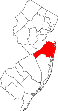
Location in the state of New Jersey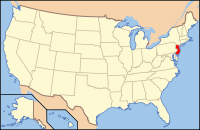
New Jersey's location in the U.S.Founded 1675 Seat Freehold Borough Largest city Middletown Township, New Jersey Area
- Total
- Land
- Water
665 sq mi (1,722 km²)
472 sq mi (1,222 km²)
193 sq mi (500 km²), 29.04%Population
- (2010)
- Density
630,380
1,336/sq mi (515.8/km²)Website www.visitmonmouth.com Monmouth County (
 /ˈmɒnməθ/) is a county located in the U.S. state of New Jersey, within the New York metropolitan area. As of the 2010 Census, the population was 630,380, up from 615,301 at the 2000 census. Its county seat is Freehold Borough.[1] The most populous municipality is Middletown Township with 66,522 residents at the time of the 2010 Census. Monmouth County ranks 42nd among the highest-income counties in the United States. It also is ranked 53rd in the United States by personal per-capita income.[2]
Contents
History
Monmouth County was established in 1675. Its name may come from the Rhode Island Monmouth Society[3] or from a suggestion from Colonel Lewis Morris. He suggested it be named after Monmouthshire in Wales, Great Britain. Other suggestions include that it was named for James Scott, 1st Duke of Monmouth (1649–1685), who had many allies among the East Jersey leadership.[4] In 1714, the first county government was established.
At the June 28, 1778 Battle of Monmouth, near Freehold, General George Washington's soldiers battled the British under Sir Henry Clinton, in the longest land battle of the American Revolutionary War. It was at Monmouth that the tactics and training from Friedrich Wilhelm von Steuben developed at Valley Forge during the winter encampment were first implemented on a large scale.[5]
Geography
According to the U.S. Census Bureau, the county has a total area of 665 square miles (1,720 km2), of which 472 square miles (1,220 km2) is land and 193 square miles (500 km2), or 29.04%, is water.
Much of Monmouth County remains flat and low-lying even far inland. However, there are some low hills in and around Holmdel Township, and one of them, Crawford Hill, the former site of a radar facility, is the county's highest point at least 380 feet (120 m) above sea level. The top portion of the hill is owned by Alcatel-Lucent and houses a research laboratory of Bell Laboratories.
The northeastern portion of the county, in the Locust neighborhood of Middletown Township and the boroughs of Highlands and Atlantic Highlands, are also very hilly. The lowest point is sea level.
Along with adjacent Ocean County, Monmouth County is a mecca of boating and fishing. Its waterways include several rivers and bays that flow into New York Harbor, Jamaica Bay and the Atlantic Ocean. The Manasquan Inlet is located in the county, which connects the Atlantic Ocean with the estuary of the Manasquan River, a bay-like body of saltwater that serves as the starting point of the Intracoastal Waterway.
Adjacent counties
- Middlesex County, New Jersey – northwest
- Ocean County, New Jersey – south
- Burlington County, New Jersey – southwest
- Mercer County, New Jersey – west
- Richmond County, New York – north
- Queens County, New York – northeast

Middlesex County Richmond County, New York Queens County, New York Mercer County 
Atlantic Ocean  Monmouth County, New Jersey

Burlington County Ocean County National protected area
Demographics
Historical populations Census Pop. %± 1790 16,918 — 1800 19,872 17.5% 1810 22,150 11.5% 1820 25,038 13.0% 1830 29,233 16.8% 1840 32,909 12.6% 1850 30,313 * −7.9% 1860 39,346 29.8% 1870 46,195 17.4% 1880 55,538 20.2% 1890 69,128 24.5% 1900 82,057 18.7% 1910 94,734 15.4% 1920 104,925 10.8% 1930 147,209 40.3% 1940 161,238 9.5% 1950 225,327 39.7% 1960 334,401 48.4% 1970 461,849 38.1% 1980 503,173 8.9% 1990 553,124 9.9% 2000 615,301 11.2% 2010 630,380 2.5% * lost territory
historical census data source:[6][7]
[8]As of the census[9] of 2000, there were 615,301 people, 224,236 households, and 160,328 families residing in the county. The population density was 1,304 people per square mile (503/km²). There were 240,884 housing units at an average density of 510 per square mile (197/km²). The racial makeup of the county was 84.39% White, 8.06% Black or African American, 0.14% Native American, 3.97% Asian, 0.02% Pacific Islander, 1.74% from other races, and 1.68% from two or more races. 6.20% of the population were Hispanic or Latino of any race. Based on the first ancestries reported by Monmouth County residents in the 2000 Census, 23% of residents were of Italian ancestry, 18% Irish, 9% German and 5% Polish ancestry.[10]
There were 224,236 households out of which 35.50% had children under the age of 18 living with them, 58.20% were married couples living together, 10.00% had a female householder with no husband present, and 28.50% were non-families. 23.80% of all households were made up of individuals and 9.60% had someone living alone who was 65 years of age or older. The average household size was 2.70 and the average family size was 3.24.
In the county the population was spread out with 26.10% under the age of 18, 6.90% from 18 to 24, 30.40% from 25 to 44, 24.10% from 45 to 64, and 12.50% who were 65 years of age or older. The median age was 38 years. For every 100 females there were 94.40 males. For every 100 females age 18 and over, there were 90.90 males.
The median income for a household in the county was $64,271, and the median income for a family was $76,823. Males had a median income of $55,030 versus $35,415 for females. The per capita income for the county was $31,149. About 4.50% of families and 6.30% of the population were below the poverty line, including 7.50% of those under age 18 and 7.00% of those age 65 or over.
Monmouth County is home to a large Irish-American population, with 141,515 residents (23% of the county's population) listed themselves as being of Irish ancestry in the 2000 Census.[11]
Government
Monmouth County is governed by a sheriff, Shaun Golden, a county clerk, Maureen Claire French, a surrogate, Rosemarie D. Peters, and a five-member Board of Chosen Freeholders, who are elected at-large for three year terms. Each January, the freeholders select one of their members to serve as the director of the board for the year to preside over the meetings and activities of the board. Monmouth County's Freeholders have both administrative and policy making powers.
The Freeholders oversee the five mandatory functions of county government delegated to it by the state. Each freeholder is assigned responsibility for one of the five functional areas: Administration and Special Services; Public Works and Engineering; Human Services, Health and Transportation; Finance and Administration of Justice. In total, the Board is responsible for supervising more than 70 county departments. A county administrator,[12] an appointed position, serves as the Chief Executive Officer. The county administrator is responsible for carrying out the policies and directives of the Board of Chosen Freeholders. In this position, the administrator also manages the daily operations of a workforce exceeding 3,000 employees.
As of 2011[update], Monmouth County's Freeholders are:[13][14]
- Freeholder Director Robert D. Clifton (R, Matawan; term ends December 31, 2013),[15]
- Freeholder Deputy Director John P. Curley (R, Red Bank; 2012),[16]
- Thomas A. Arnone (R, Neptune City; 2013),
- Lillian G. Burry (R, Colts Neck Township; 2011)[17] and
- Amy A. Mallet (D, Fair Haven, 2011).[18]
Politics
Monmouth County has trended in favor of the Republican Party. The Republican Party had held all five Freeholder seats until 2006, but after the 2006 and 2008 elections, Democrats controlled the Board by a 3–2 Margin. The Board swung back in favor of the Republicans after the 2009 election when Republican John Curley beat Democrat Sean Byrnes. Both were running to succeed former Freeholder Director Barbara McMorrow, a Democrat, who had chosen not to seek re-election. In 2010, former mayor of Neptune City, NJ, Thomas Arnone (R) and incumbent Freeholder Robert Clifton (R) won seats giving Republicans control of the Board of Chosen Freeholders by a 4–1 margin.[19]
In the 2004 U.S. Presidential election, George W. Bush carried the county by a 10% margin over John Kerry, with Kerry carrying the state by 6.7% over Bush.[20] In 2008, John McCain carried Monmouth by a unexpectedly close margin of only 3.7% margin over Barack Obama, with Obama winning New Jersey by 15.5% over McCain. In the state's U.S. Senatorial election that same year, Dick Zimmer also won here, by a 6.2% margin over incumbent Frank Lautenberg, with Lautenberg winning reelection by 14.1% over Zimmer.[21] In the 2009 Gubernatorial Election, Republican Chris Christie received 62% of the vote, defeating Democrat Jon Corzine, who received around 31%.
Several minor political parties have local chapters in Monmouth County, most recently the Socialist Party of Monmouth and Ocean Counties was added to that list.
Transportation
Monmouth County has numerous important roads that pass through. The state routes include Route 18, Route 33, Route 34, Route 35, Route 36, Route 66, Route 70, Route 71, Route 79, and Route 138. US Route 9 also passes through and practically bisects Monmouth.
Limited access roads include the Garden State Parkway and Interstate 195 (the only interstate to pass through the county).
The New Jersey Turnpike (I-95) just misses the county border by a fifth of a mile near Upper Freehold Township.
Notable residents (former and present)
- Bud Abbott – comedian and actor, member of comedy team Abbott and Costello
- Grant Aleksander – film and television actor
- Count Basie – jazz pianist, organist, bandleader and composer
- Clint Black – country music singer-songwriter and actor
- Jon Bon Jovi – songwriter, singer and musician
- Donald Brown – football player with the Indianapolis Colts
- Alyssa Campanella – Miss USA 2011
- Connie Chung – TV journalist
- Mary Higgins Clark – novelist
- Stephen Crane – writer
- Danny DeVito – actor and comedian
- Khigh Dheigh – actor ("The Manchurian Candidate", "Hawaii Five-O")
- Kirsten Dunst – actress, model, and singer
- Philip Freneau – poet during the American Revolutionary War
- Sammi "Sweetheart" Giancola – of MTV reality show Jersey Shore
- Juanita Hall – musical theater and film actress
- Garret A. Hobart – 24th Vice President of the United States
- Joe Klecko – football player
- Queen Latifah – rapper, singer, actress and model
- John Eatton Le Conte - early naturalist
- Norman Mailer – writer, producer and film director
- Melanie – singer and songwriter ("Brand New Key", "Lay Down (Candles in the Rain)", "What Have They Done To My Song Ma")
- Jason Mewes – actor
- Knowshon Moreno – football player with the Denver Broncos
- Jack Nicholson – actor, director, producer and screenwriter
- Dorothy Parker – writer and poet, member of the Algonquin Round Table
- Kal Penn – actor and politician
- Johnny Petraglia – bowler
- Robert Pinsky – Poet Laureate of the United States from 1997–2000
- Tab Ramos – soccer player
- Geraldo Rivera – news anchor and talk show host
- Natalie Schafer – actress (Gilligan's Island)
- Kevin Smith – director, producer and actor
- Michael Sorrentino - television personality
- Anthony Spalliero - corrupt real estate developer with organized crime ties
- Bruce Springsteen – songwriter, singer and musician
- John Lloyd Stephens - explorer
- T. M. Stevens – bass guitarist
- Ashley Tisdale – actress, singer, and television producer
- James van Riemsdyk – ice hockey player with the Philadelphia Flyers
- Phil Villapiano – football player
- Brian Williams – journalist
- Alexander Woollcott – critic and commentator, member of the Algonquin Round Table
Municipalities
 Index map of Monmouth County Municipalities (click to see index key)
In alphabetical order:
- Aberdeen Township (50)
- Allenhurst (14)
- Allentown (38)
- Asbury Park (11)
- Atlantic Highlands (29)
- Avon-by-the-Sea (8)
- Belmar (7)
- Bradley Beach (10)
- Brielle (1)
- Colts Neck Township (47)
- Deal (15)
- Eatontown (24)
- Englishtown (36)
- Fair Haven (20)
- Farmingdale (34)
- Freehold Borough (35)
Fire departments
With the exception of the City of Asbury Park and Long Branch,[22] the remainder of the municipalities in the county have volunteer fire departments with the largest in Middletown with 11 stations and 350 active members, special services, air and fire police units. The Middletown Township Fire Department also has its own training facility. However, in terms of HazMat emergencies, very few towns, notably Middletown Township which has a special services unit, have special units to respond to these and so the HAZMAT unit from Fort Monmouth responded to most HazMat cases prior to the closing of the base.
Education
Brookdale Community College is the two-year community college for Monmouth County, one of a network of 19 county colleges statewide. The school is in Lincroft and was founded in 1967.
Monmouth University is a four-year private university located in West Long Branch.
Rutgers, the State University of New Jersey has a partnership with Brookdale Community College which offers Bachelor degree completion programs at Brookdale's Freehold campus. For more information on this program please visit http://www.wmhec.rutgers.edu.
In addition to multiple public high schools, there are many parochial schools in Monmouth County such as St. Rose High School, Red Bank Catholic High School, Christian Brothers Academy, St. John Vianney High School, and Mater Dei High School; as well as one secular private school, Ranney School.
The county has an extensive vocational high school program, known as the Monmouth County Vocational School District including 5 magnet schools:
- Academy of Allied Health & Science (Allied) in Neptune Township
- Biotechnology High School (BioTech) in Freehold
- Communications High School (Communications,CHS) in Wall Township
- High Technology High School (High Tech) in Lincroft (located on the Brookdale Community College campus)
- Marine Academy of Science and Technology (MAST) in Sandy Hook
See also
- USS Monmouth County (LST-1032)
- Monmouth County Historical Association
- National Register of Historic Places listings in Monmouth County, New Jersey
- List of Monmouth County Freeholder directors
References
- ^ "Find a County". National Association of Counties. http://www.naco.org/Counties/Pages/FindACounty.aspx. Retrieved 2011-06-07.
- ^ 250 Highest Per Capita Personal Incomes of the 3111 Counties in the United States, 2006, Bureau of Economic Analysis. Accessed May 2, 2008.
- ^ The Origin of New Jersey Place Names: M, GetNJ.com. Accessed December 15, 2007.
- ^ How Monmouth County Got Its Name, Monmouth County, New Jersey. Accessed August 14, 2008.
- ^ Capuzzo, Jill P. "British Beware: Monmouth Redux", The New York Times, May 18, 2003. Accessed August 14, 2008. "The largest land artillery battle of the Revolutionary War, the Battle of Monmouth marked a significant turning point in the colonies' fight against the British crown."
- ^ "New Jersey Resident Population by County: 1880 – 1930". http://www.wnjpin.net/OneStopCareerCenter/LaborMarketInformation/lmi01/poptrd5.htm.
- ^ "Geostat Center: Historical Census Browser". University of Virginia Library. http://fisher.lib.virginia.edu/collections/stats/histcensus/. Retrieved 2007-03-02.
- ^ "U.S. Census Bureau Delivers New Jersey's 2010 Census Population Totals". U.S. Census Bureau. 2011-02-03. http://www.census.gov/newsroom/releases/archives/2010_census/cb11-cn15.html. Retrieved 2011-02-05.
- ^ "American FactFinder". United States Census Bureau. http://factfinder.census.gov. Retrieved 2008-01-31.
- ^ Monmouth County, New Jersey, City-Data.com. Accessed December 16, 2007.
- ^ Monmouth County, New Jersey, United States Census Bureau. Accessed September 20, 2007.
- ^ County Administrator Monmouth County, New Jersey. Accessed June 16, 2010.
- ^ Board of Chosen Freeholders, Monmouth County, New Jersey. Accessed January 7, 2011.
- ^ Rizzo, Nina. "Monmouth County freeholders sworn into office", Asbury Park Press, January 6, 2011. Accessed January 7, 2011.
- ^ Freeholder Director Robert D. Clifton, Monmouth County, New Jersey. Accessed January 7, 2011.
- ^ Deputy Director Freeholder John P. Curley, Monmouth County, New Jersey. Accessed January 7, 2011.
- ^ Freeholder Lillian G. Burry, Monmouth County, New Jersey. Accessed January 7, 2011.
- ^ Freeholder Amy A. Mallet, Monmouth County, New Jersey. Accessed January 7, 2011.
- ^ New Jersey Division of Elections. "New Jersey Division of Elections". http://www.state.nj.us/state/elections/election-results/2010-monmouth-co-election-results.pdf. Retrieved march 13, 2011.
- ^ New Jersey Presidential Election Returns by County 2004, Eagleton Institute of Politics at Rutgers University. Accessed August 31, 2008.
- ^ U.S. Election Atlas
- ^ Apfdhome
External links
 State of New Jersey
Topics Regions - Atlantic Coastal Plain
- Central Jersey
- Delaware River Region
- Delaware Valley
- Gateway Region
- Gold Coast
- Highlands
- Jersey Shore
- Meadowlands
- New York metro area
- North Hudson
- North Jersey
- Pascack Valley
- Piedmont
- Pine Barrens
- Raritan Bayshore
- Ridge-and-Valley Appalachians
- Southern Shore Region
- Skylands Region
- South Jersey
- Tri‑State Region
- West Hudson
Counties Major cities New York-Newark-Bridgeport Combined Statistical Area Counties 
Major city Cities and towns
100k–999kBridgeport • Elizabeth • Huntington • Jersey City • New Haven • Newark • Paterson • Stamford • Waterbury • YonkersCities and towns
25k–99kBayonne • Branford • Cheshire • Clifton • Danbury • East Haven • East Orange • Englewood • Fairfield • Garfield • Greenwich • Hackensack • Hamden • Hoboken • Howell, New Jersey Kearny • Long Beach • Long Branch • Meriden • Middletown • Milford • Mount Vernon • Naugatuck • New Brunswick • New Milford • New Rochelle • Newburgh • Newtown • Norwalk • Passaic • Perth Amboy • Plainfield • Poughkeepsie • Rahway • Shelton • Stratford • Torrington • Trenton • Trumbull • Union City • Wallingford • West Haven • Westfield • Westport • White PlainsCities and towns
10k–25kAnsonia • Asbury Park • Beacon • Bethel • Brookfield • Darien • Derby • Dover • Guildford • Guttenberg • Harrison (NJ) • Harrison (NY) • Kingston • Linden • Madison • Monroe • Morristown • New Canaan • New Fairfield • North Branford • North Haven • Orange • Plymouth • Peekskill • Ridgefield • Rye • Scarsdale • Secaucus • Seymour • Southbury • Summit • Watertown • West New York • Weston • Wilton • Winchester • WolcottSub-regions Central Jersey • Greater Danbury • Greater New Haven • Greater Waterbury • Hudson Valley • Litchfield Hills • Long Island • North Jersey • Southwestern ConnecticutCategories:- New Jersey counties
- Monmouth County, New Jersey
- Central Jersey


Wikimedia Foundation. 2010.