- Cuyahoga County, Ohio
-
Cuyahoga County, Ohio 
Seal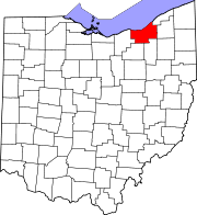
Location in the state of Ohio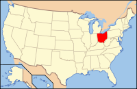
Ohio's location in the U.S.Founded June 7, 1807[1] Named for "crooked river" possibly in Algonquian Seat Cleveland Largest city Cleveland Area
- Total
- Land
- Water
1,246 sq mi (3,226 km²)
458 sq mi (1,187 km²)
787 sq mi (2,038 km²), 63.19%Population
- (2010)
- Density
1,280,122
2,795/sq mi (1,078/km²)Website www.cuyahogacounty.us Cuyahoga County (
 /ˌkaɪ.əˈhɒɡə/ or /ˌkaɪ.əˈhoʊɡə/)[2][3][4][5] is a county located in the state of Ohio, United States. It is the most populous county in Ohio; as of the 2010 census, the population was 1,280,122.[6] Its county seat is Cleveland.[7] Cuyahoga County is part of Greater Cleveland, a metropolitan area, and Northeast Ohio, a thirteen-county region, joined together in economic development initiatives. The county is named after the Native American word (possibly Algonquian) Cuyahoga, which means "crooked river".[8] The name is also assigned to the Cuyahoga River, which bisects the county. Former U.S. President James A. Garfield was born in what was Cuyahoga County's Orange Township.
Contents
History
Cuyahoga County was organized on June 7, 1807.[9] It was later reduced by the creation of Huron, Lake, and Lorain Counties.[10] It was named after the Cuyahoga River.
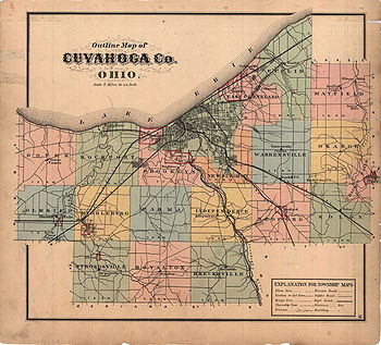 Cuyahoga County in 1874
Geography
According to the U.S. Census Bureau, the county has a total area of 1,246 square miles (3,227.1 km2).458 square miles (1,186.2 km2) is land and 787 square miles (2,038.3 km2) (63.19%) is water. A portion of Cuyahoga Valley National Park is located in the southeastern portion of the county.
Major highways
 Interstate 71
 Interstate 271
 Interstate 77
 Interstate 80
 Interstate 480
 Interstate 90
 Interstate 490
 U.S. Route 6
 U.S. Route 20
 U.S. Route 42
 U.S. Route 322
 U.S. Route 422
Adjacent counties
- Across Lake Erie lies Chatham-Kent and Elgin County, Ontario, Canada (north)
- Lake County (northeast)
- Geauga County (east)
- Summit County (southeast)
- Medina County (southwest)
- Lorain County (west)
- Portage County (southeast corner)
Demographics
Historical populations Census Pop. %± 1810 1,459 — 1820 6,328 333.7% 1830 10,373 63.9% 1840 26,506 155.5% 1850 48,099 81.5% 1860 78,033 62.2% 1870 132,010 69.2% 1880 196,943 49.2% 1890 309,970 57.4% 1900 439,120 41.7% 1910 637,425 45.2% 1920 943,495 48.0% 1930 1,201,455 27.3% 1940 1,217,250 1.3% 1950 1,389,532 14.2% 1960 1,647,895 18.6% 1970 1,721,300 4.5% 1980 1,498,400 −12.9% 1990 1,412,140 −5.8% 2000 1,393,978 −1.3% 2010 1,280,122 −8.2% Population 1810-2007.[1]  Cuyahoga County population (Source: United States Census, 2000)
As of the census[11] of 2000, there were 1,393,978 people, 571,457 households, and 354,874 families residing in the county. The population density was 3,040 people per square mile (1,174/km²). There were 616,903 housing units at an average density of 1,346 per square mile (520/km²). The racial makeup of the county was 67.35% White, 27.45% African American, 0.18% Native American, 1.81% Asian, 0.02% Pacific Islander, 1.50% from other races, and 1.68% from two or more races. 3.38% of the population were Hispanic or Latino of any race. 12.3% were of German, 9.1% Irish, 8.7% Italian and 7.3% Polish ancestry according to Census 2000. 89.0% spoke English and 3.2% Spanish as their first language.
There were 571,457 households out of which 28.50% had children under the age of 18 living with them, 42.40% were married couples living together, 15.70% had a female householder with no husband present, and 37.90% were non-families. 32.80% of all households were made up of individuals and 12.10% had someone living alone who was 65 years of age or older. The average household size was 2.39 and the average family size was 3.06.
In the county the population was spread out with 25.00% under the age of 18, 8.00% from 18 to 24, 29.30% from 25 to 44, 22.20% from 45 to 64, and 15.60% who were 65 years of age or older. The median age was 37 years. For every 100 females there were 89.50 males. For every 100 females age 18 and over, there were 85.20 males.
The median income for a household in the county was $39,168, and the median income for a family was $49,559. Males had a median income of $39,603 versus $28,395 for females. The per capita income for the county was $22,272. About 10.30% of families and 13.10% of the population were below the poverty line, including 19.40% of those under age 18 and 9.30% of those age 65 or over.
Government
Main articles: Cuyahoga County Council and Ohio county governmentCuyahoga County had long been led by a three-member Board of County Commissioners. However, on November 3, 2009, county voters overwhelmingly approved the adoption of a county charter form of government, which replaced the three-commissioner form of county government with an elected county executive and an 11-member county council. Each council member represents a single district; there are no at-large districts. Summit County is the only other Ohio county with this form of government.
In the November 2, 2010 election, Lakewood mayor Ed FitzGerald defeated Matt Dolan to become the first Cuyahoga County executive.[12] The first Cuyahoga County Council was also elected, with Democrats winning the majority (8-3) over the Republicans.[13]
Politics
Cuyahoga County is heavily Democratic in voter registration.
Presidential election results, 1960–2008 Year Democrat Republican 2008 68.50% 441,836 30.44% 196,369 2004 66.57% 448,503 32.89% 221,600 2000 62.62% 359,913 33.42% 192,099 1996 60.75% 341,357 29.15% 163,770 1992 52.72% 337,548 29.24% 187,186 1988 58.79% 353,401 40.33% 242,439 1984 55.65% 362,626 43.60% 284,094 1980 50.02% 307,448 41.47% 254,883 1976 56.03% 349,186 41.01% 255,594 1972 48.15% 317,670 49.94% 329,493 1968 53.95% 363,540 35.44% 238,791 1964 71.50% 492,911 28.50% 196,436 1960 59.83% 429,030 40.17% 288,056 Communities
 Map of Cuyahoga County, Ohio With Municipal and Township Labels
Cities
Villages
Townships
Parks
Cuyahoga County is served by the Cleveland Metroparks system. Its 16 reservations provide more than 21,000 acres (8,500 ha) of green space and recreational amenities.[14] The county is home to part of Cuyahoga Valley National Park, which extends southward into Summit County.
See also
References
- ^ a b "Ohio County Profiles: Cuyahoga County" (PDF). Ohio Department of Development. http://www.odod.state.oh.us/research/FILES/S0/Cuyahoga.pdf. Retrieved 2007-04-28.
- ^ Feran, Tom (2004-02-13). "Shooing the hog out of Cuyahoga". The Plain Dealer. http://infoweb.newsbank.com/iw-search/we/InfoWeb?p_action=doc&p_topdoc=1&p_docnum=1&p_sort=YMD_date:D&p_product=NewsBank&p_text_direct-0=document_id=(%20100B6B280DC46277%20)&p_docid=100B6B280DC46277&p_theme=aggregated5&p_queryname=100B6B280DC46277&f_openurl=yes&p_nbid=E5DN55ITMTE5OTkxMTg3NC41MzY1NTE6MToxMzo2Ni4yMTMuNDEuMTQy&&p_multi=CPDB.
- ^ Feran, Tom (2006-06-02). "It's a Cleveland thing, so to speak". The Plain Dealer. http://infoweb.newsbank.com/iw-search/we/InfoWeb?p_action=doc&p_topdoc=1&p_docnum=1&p_sort=YMD_date:D&p_product=NewsBank&p_text_direct-0=document_id=(%20112043416CC2CD20%20)&p_docid=112043416CC2CD20&p_theme=aggregated5&p_queryname=112043416CC2CD20&f_openurl=yes&p_nbid=F58P50SOMTE5OTkxMjUxOS4yOTM5NjU6MToxMzo2Ni4yMTMuNDEuMTQy&&p_multi=CPDB.
- ^ Siegel, Robert; Block, Melissa (2009-06-23). "Letters: Cuyahoga River". All Things Considered (National Public Radio). http://www.npr.org/templates/story/story.php?storyId=105828999. Retrieved 2009-06-23.
- ^ McIntyre, Michael K. (2009-06-28). "How to pronounce 'Cuyahoga' turns into a national debate: Tipoff". The Plain Dealer. http://www.cleveland.com/tipoff/index.ssf/2009/06/how_to_pronounce_cuyahoga_turn.html. Retrieved 2009-06-29.
- ^ "Total Population, 2010". Cuyahoga County Planning Commission. 2011. http://planning.co.cuyahoga.oh.us/census/2010population.html. Retrieved March 19, 2011.
- ^ "Find a County". National Association of Counties. http://www.naco.org/Counties/Pages/FindACounty.aspx. Retrieved 2011-06-07.
- ^ "Cuyahoga County data". Ohio State University Extension Data Center. http://www.osuedc.org/profiles/profile_entrance.php?fips=39035&sid=0. Retrieved 2007-04-28.[dead link]
- ^ "Federal Roster: Counties of Ohio, Derivation of Name and Date of Erection". http://www.sos.state.oh.us/SOS/PublicAffairs/fedRoster.aspx?Section=1585. Retrieved 2007-07-22.
- ^ "Ohio Genealogy Clickable County Map". Archived from the original on 2007-11-18. http://web.archive.org/web/20071118074514/http://www.rootsweb.com/~usgenweb/oh/1/counties.htm. Retrieved 2007-07-25.
- ^ "American FactFinder". United States Census Bureau. http://factfinder.census.gov. Retrieved 2008-01-31.
- ^ Byrne, Brian (November 3, 2010). "Ed FitzGerald is first Cuyahoga County executive". The Plain Dealer (Cleveland, Ohio). http://www.cleveland.com/sun/all/index.ssf/2010/11/ed_fitzgerald_is_first_cuyahog.html. Retrieved November 16, 2010.
- ^ Garrett, Amanda (November 2, 2010). "Three Republicans heading toward victory on Cuyahoga County Council; Dems likely to take other 8 seats". The Plain Dealer (Cleveland, Ohio). http://www.cleveland.com/politics/index.ssf/2010/11/cuyahoga_county_council_5_race.html. Retrieved November 16, 2010.
- ^ "Cleveland Metroparks: Plan Your Visit". http://www.clemetparks.com/visit/. Retrieved July 5, 2011.
External links

Lake Erie Lake County Lorain County 
Geauga County  Cuyahoga County, Ohio

Medina County Summit County and Portage County  State of Ohio
Columbus (capital) Topics History · Geography · People · Government · Elections · Delegations · Economy · Demographics · Education · Colleges and universities · Visitor Attractions · Portal
Regions Allegheny Plateau · Appalachian Ohio · Black Swamp · The Bluegrass · Extreme Northwest Ohio · Glacial till plains · Lake Erie · Lake Erie Islands · Miami Valley · Northwest Ohio · Western Reserve
Metro areas Akron · Canton-Massillon · Cincinnati · Cleveland · Columbus · Dayton · Findlay-Tiffin · Ironton · Lima · Mansfield · Steubenville · Toledo · Youngstown-Warren
Largest cities Akron · Canton · Cincinnati · Cleveland · Cleveland Heights · Columbus · Cuyahoga Falls · Dayton · Elyria · Euclid · Hamilton · Kettering · Lakewood · Lorain · Massillon · Mansfield · Middletown · Newark · Parma · Springfield · Toledo · Youngstown Wooster ·
Counties Adams · Allen · Ashland · Ashtabula · Athens · Auglaize · Belmont · Brown · Butler · Carroll · Champaign · Clark · Clermont · Clinton · Columbiana · Coshocton · Crawford · Cuyahoga · Darke · Defiance · Delaware · Erie · Fairfield · Fayette · Franklin · Fulton · Gallia · Geauga · Greene · Guernsey · Hamilton · Hancock · Hardin · Harrison · Henry · Highland · Hocking · Holmes · Huron · Jackson · Jefferson · Knox · Lake · Lawrence · Licking · Logan · Lorain · Lucas · Madison · Mahoning · Marion · Medina · Meigs · Mercer · Miami · Monroe · Montgomery · Morgan · Morrow · Muskingum · Noble · Ottawa · Paulding · Perry · Pickaway · Pike · Portage · Preble · Putnam · Richland · Ross · Sandusky · Scioto · Seneca · Shelby · Stark · Summit · Trumbull · Tuscarawas · Union · Van Wert · Vinton · Warren · Washington · Wayne · Williams · Wood · Wyandot
Categories:- Ohio counties
- 1807 establishments in the United States
- Populated places established in 1807
- Cuyahoga County, Ohio


Wikimedia Foundation. 2010.