- Harney County, Oregon
-
Harney County, Oregon 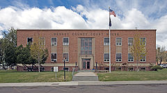
Harney County Courthouse in Burns 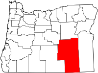
Location in the state of Oregon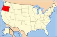
Oregon's location in the U.S.Founded 1889 Seat Burns Area
- Total
- Land
- Water
10,226 sq mi (26,485 km²)
10,134 sq mi (26,247 km²)
92 sq mi (238 km²), 0.90%Population
- (2010)
- Density
7,422
1/sq mi (.28/km²)Website www.co.harney.or.us Harney County is a county located in the U.S. state of Oregon. It is included in the eight-county definition of Eastern Oregon. Established in 1889, the county is named in honor of William S. Harney, a military officer of the period, who was involved in the Pig War and popular in the Pacific Northwest. The county seat is Burns. In 2010, the county's population was 7,422. Harney County is Oregon's largest county in area.
Contents
History
The Native Americans living in this region at the time of the Lewis and Clark Expedition were the Northern Paiute, who fought with the Tenino and Wasco peoples. Peter Skene Ogden was the first known European to explore this area in 1826 when he led a fur brigade for the Hudson's Bay Company.
Harney County was carved out of the southern two-thirds of Grant County on February 25, 1889. A fierce political battle, with armed "night riders" who spirited county records from Harney to Burns, ended with Burns as the county seat in 1890.
The Malheur River Indian Reservation was created by executive order on March 14, 1871 and the Northern Paiute within the Oregon state boundaries were settled there. Descendants of these people form a federally recognized tribal entity, the Burns Paiute Tribe, which has about 341 members.[1] Fewer than 35.5% of the tribal members live on the Burns Paiute Indian Colony near Burns.[1] The tribe earns revenue from a small casino, the Old Camp Casino, and renting out communal tribal lands for grazing rights to local ranchers.
Economy
Three industries have traditionally provided the county's economic base: ranching, sheep raising, and timber. The railroad, which extended into the area in 1883, served as a catalyst to the cattle industry but later contributed to its decline. By bringing farmers and sheep men to the area, it created increased competition for productive land. Harvesting and breeding of wild horses was lucrative for a period. Harney County shares the largest Ponderosa Pine forest in the nation with Grant County. Its abundance of game, numerous campsites and excellent fishing have stimulated fast-growing recreational activities.
Although county lands were open to homesteading from 1862 to 1934, the U.S. Bureau of Land Management still owns more than three million acres (12,000 km²), or 62% of the lands within the county boundaries. Facilitated on the national level by the Carey act of 1894, arid land in Harney County was donated to the state for irrigation and settlement, but all water development efforts failed.
Eventually all land claims filed under the reclamation legislation were abandoned or nullified. Malheur National Wildlife Refuge was established in 1908 and expanded in 1936. The refuge now includes 159,872 acres (646.98 km2). Borax has been mined in the Steens area, and uranium has been found on its south side.
Politics
Like all counties in eastern Oregon, the majority of registered voters who are part of a political party in Harney County are members of the Republican Party. In the 2008 presidential election 70.45% of Harney County voters voted for Republican John McCain, while 25.79% voted for Democrat Barack Obama and 3.73% of voters either voted for a Third Party candidate or wrote in a candidate.[2] These numbers show a slight shift towards the Democratic candidate when compared to the 2004 presidential election, in which 76% of Harney Country voters voted for George W. Bush, while 22.7% voted for John Kerry, and 1.3% of voters either voted for a Third Party candidate or wrote in a candidate.[3]
Geography
 Sign welcoming drivers to Harney County
According to the U.S. Census Bureau, the county has a total area of 10,226 square miles (26,485.2 km2), of which 10,134 square miles (26,246.9 km2) is land and 92 square miles (238.3 km2) is water, mostly as part of Malheur Lake. The total area is 0.90% water.
Harney is the largest county in Oregon and the ninth largest county in the United States (excluding boroughs and census areas in Alaska).
Steens Mountain is the county's most prominent geographical feature, rising 9,700 feet (3,000 m) above sea level and spanning many miles across a region that is otherwise fairly flat. To its southeast is the Alvord Desert, the driest place in Oregon, and to the north lies Harney Basin, which contains Malheur Lake and Harney Lake.
Adjacent counties
- Lake County, Oregon - (west)
- Deschutes County, Oregon - (northwest)
- Crook County, Oregon - (northwest)
- Grant County, Oregon - (north)
- Malheur County, Oregon - (east)
- Humboldt County, Nevada - (south)
- Washoe County, Nevada - (southwest)

Deschutes County and Crook County Grant County Lake County 
Malheur County  Harney County, Oregon

Washoe County, Nevada Humboldt County, Nevada National protected areas
Demographics
Historical populations Census Pop. %± 1890 2,559 — 1900 2,598 1.5% 1910 4,059 56.2% 1920 3,992 −1.7% 1930 5,920 48.3% 1940 5,374 −9.2% 1950 6,113 13.8% 1960 6,744 10.3% 1970 7,215 7.0% 1980 8,314 15.2% 1990 7,060 −15.1% 2000 7,609 7.8% 2010 7,422 −2.5% [5][6][7] As of the census[8] of 2000, there were 7,609 people, 3,036 households, and 2,094 families residing in the county. The population density was 1 people per square mile (0/km²). There were 3,533 housing units at an average density of 0 per square mile (0/km²). The racial makeup of the county was 91.93% White, 3.97% Native American, 0.51% Asian, 0.13% Black or African American, 0.07% Pacific Islander, 1.30% from other races, and 2.09% from two or more races. 4.15% of the population were Hispanic or Latino of any race. 21.1% were of German, 11.1% American, 10.3% Irish and 9.7% English ancestry according to Census 2000.
There is a small, but significant Spanish Basque community.[9]
Approximately 75% of the population of Harney County lives in the Burns-Hines municipal district. Crane is the only other localised population center, with less than 7% of the population of Harney County. Lawen and Riley have no localised populations. The remaining population of Harney County is dispersed throughout the countryside, mostly dwelling on large ranches.
There were 3,036 households out of which 29.40% had children under the age of 18 living with them, 58.00% were married couples living together, 6.80% had a female householder with no husband present, and 31.00% were non-families. 25.90% of all households were made up of individuals and 10.20% had someone living alone who was 65 years of age or older. The average household size was 2.45 and the average family size was 2.94.
In the county, the population was spread out with 26.00% under the age of 18, 6.40% from 18 to 24, 26.60% from 25 to 44, 26.10% from 45 to 64, and 15.00% who were 65 years of age or older. The median age was 40 years. For every 100 females there were 102.90 males. For every 100 females age 18 and over, there were 98.20 males.
The median income for a household in the county was $30,957, and the median income for a family was $36,917. Males had a median income of $27,386 versus $21,773 for females. The per capita income for the county was $16,159. About 8.60% of families and 11.80% of the population were below the poverty line, including 12.70% of those under age 18 and 13.90% of those age 65 or over.
Communities
Incorporated cities
Unincorporated communities
- Dunnean
- Fields
- Frenchglen
- Frost Mill
- Harney
- Suntex
- Trout Creek
- Van
- Venator
- Voltage
- Wagontire
- Whitehorse
See also
References
- ^ a b Wadatika Today
- ^ http://co.harney.or.us/PDF_Files/County%20Clerk/Election%20Results%20Update%202008/Eection%20Results%20Nov%204%202008%20General.pdf Retrieved on 4/21/09
- ^ http://www.city-data.com/county/Harney_County-OR.html Retrieved on 4/21/09
- ^ http://www.sos.state.or.us/elections/votreg/mar09.pdf Retrieved 4/21/09
- ^ http://www.census.gov/population/www/censusdata/cencounts/files/or190090.txt
- ^ http://factfinder2.census.gov
- ^ http://mapserver.lib.virginia.edu/
- ^ "American FactFinder". United States Census Bureau. http://factfinder.census.gov. Retrieved 2008-01-31.
- ^ Etulain, Richard W.. "Basques". The Oregon Encyclopedia. http://oregonencyclopedia.org/entry/view/basques/. Retrieved 2008-04-03.
Municipalities and communities of Harney County, Oregon Cities 
Unincorporated
communitiesIndian reservation Burns Paiute Indian Reservation
Categories:- Oregon counties
- Harney County, Oregon
- 1889 establishments
- Basque American history


Wikimedia Foundation. 2010.