- Centre County, Pennsylvania
-
Centre County, Pennsylvania 
Seal
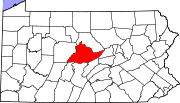
Location in the state of Pennsylvania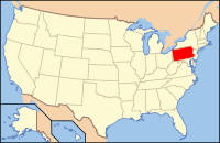
Pennsylvania's location in the U.S.Founded February 13, 1800 Seat Bellefonte Largest city State College Area
- Total
- Land
- Water
1,112 sq mi (2,880 km²)
1,108 sq mi (2,870 km²)
4 sq mi (10 km²), 0.39%Population
- (2010)
- Density
153,990
139/sq mi (53.6/km²)Website co.centre.pa.us Centre County is a county located in the U.S. state of Pennsylvania. It is part of the State College, Pennsylvania Metropolitan Statistical Area. As of 2010, the population was 153,990.
Centre County was created on February 13, 1800, from parts of Huntingdon, Lycoming, Mifflin, and Northumberland counties and named for its central location in the state. Its county seat is Bellefonte[1].
Contents
Law and government
County Commissioners
- Steven Dershem, Chairman, Republican
- Chris Exarchos, Republican
- Michael Pipe, Democrat
Other county offices
- Clerk of Courts and Prothonotary, Debra Immel, Democrat
- Controller, Charles Witmer, Republican
- Coroner, Scott Sayers, Democrat
- District Attorney, Stacy Parks Miller, Democrat
- Recorder of Deeds, Joe Davidson, Republican
- Register of Wills, Kim Barton, Republican
- Sheriff, Denny Nau, Democrat
- Treasurer, Rich Fornicola, Republican
Pennsylvania State Senate
- Jake Corman, Republican, Pennsylvania's 34th Senatorial District
- John N. Wozniak, Democrat, Pennsylvania's 35th Senatorial District
Pennsylvania House of Representatives
- Michael K. Hanna Sr., Democrat, Pennsylvania's 76th Representative District
- Scott Conklin, Democrat, Pennsylvania's 77th Representative District
- Kerry Benninghoff, Republican, Pennsylvania's 171st Representative District
United States House of Representatives
- Glenn "G.T." Thompson, Republican, Pennsylvania's 5th congressional district
United States Senate
Politics
As of November 2008, there are 106,169 registered voters in Centre County [1].
- Democratic: 46,541 (43.84%)
- Republican: 40,881 (38.51%)
- Other Parties: 18,747 (17.66%)
Centre County had for many years been a strongly Republican county like most of rural Pennsylvania. In recent years, however, it has been becoming more competitive. In 2000 George W. Bush defeated Al Gore with 52% of the vote to Gore's 43%. In 2004 Bush won the county by a much smaller margin. Bush won 51% to Kerry's 47%, a margin of only 4%. In 2006, Governor Ed Rendell and Bob Casey Jr. both carried Centre and Democrat Scott Conklin decisively won the State House seat left open by the retirement of Republican Lynn Herman in the 77th district. In 2008, the Democrats captured the countywide registration edge, Barack Obama carried the county with 55% of the vote to McCain's 44%, and the other three statewide winners (Rob McCord for Treasurer, Jack Wagner for Auditor General, and Tom Corbett for Attorney General) also carried Centre.
Geography
According to the U.S. Census Bureau, the county has a total area of 1,112 square miles (2,880.1 km2), of which 1,108 square miles (2,869.7 km2) is land and 4 square miles (10.4 km2) (0.39%) is water.
Adjacent counties
- Clinton County (north)
- Union County (east)
- Mifflin County (southeast)
- Huntingdon County (south)
- Blair County (south)
- Clearfield County (west)
Significant Topographic Features
Demographics
Historical populations Census Pop. %± 1810 10,681 — 1820 13,796 29.2% 1830 18,879 36.8% 1840 20,492 8.5% 1850 23,355 14.0% 1860 27,000 15.6% 1870 34,418 27.5% 1880 37,922 10.2% 1890 43,269 14.1% 1900 42,894 −0.9% 1910 43,424 1.2% 1920 44,304 2.0% 1930 46,294 4.5% 1940 52,608 13.6% 1950 65,922 25.3% 1960 78,580 19.2% 1970 99,267 26.3% 1980 112,760 13.6% 1990 123,786 9.8% 2000 135,760 9.7% 2010 153,990 13.4% As of the 2010 census, the county was 89.4% White, 3.0% Black or African American, 0.1% Native American, 5.2% Asian, and 1.5% were two or more races. 2.4% of the population were of Hispanic or Latino ancestry[2].
As of the census[2] of 2000, there were 135,758 people, 49,323 households, and 28,508 families residing in the county. The population density was 123 people per square mile (47/km²). There were 53,161 housing units at an average density of 48 per square mile (19/km²). The racial makeup of the county was 91.44% White, 2.61% Black or African American, 0.14% Native American, 3.96% Asian, 0.07% Pacific Islander, 0.74% from other races, and 1.05% from two or more races. 1.65% of the population were Hispanic or Latino of any race. 26.1% were of German, 9.8% Irish, 9.3% American, 8.7% Italian and 8.0% English ancestry according to Census 2000. 91.9% spoke English, 1.8% Spanish and 1.1% Chinese or Mandarin as their first language.
There were 49,323 households out of which 25.50% had children under the age of 18 living with them, 48.90% were married couples living together, 6.10% had a female householder with no husband present, and 42.20% were non-families. 26.60% of all households were made up of individuals and 7.60% had someone living alone who was 65 years of age or older. The average household size was 2.45 and the average family size was 2.95.
In the county, the population was spread out with 18.00% under the age of 18, 26.80% from 18 to 24, 26.40% from 25 to 44, 18.40% from 45 to 64, and 10.40% who were 65 years of age or older. The median age was 29 years. For every 100 females there were 104.30 males. For every 100 females age 18 and over, there were 104.40 males.
Municipalities
Under Pennsylvania law, there are four types of incorporated municipalities: cities, boroughs, townships, and, in at most two cases, towns. The following boroughs and townships are located in Centre County:
Boroughs
- South Philipsburg (former)
- State College
- Unionville
Townships
- Benner Township
- Boggs Township
- Burnside Township
- College Township
- Curtin Township
- Ferguson Township
- Gregg Township
- Haines Township
- Halfmoon Township
- Harris Township
- Howard Township
- Huston Township
- Liberty Township
- Marion Township
- Miles Township
- Patton Township
- Penn Township
Census-designated places
Census-designated places are geographical areas designated by the U.S. Census Bureau for the purposes of compiling demographic data. They are not actual jurisdictions under Pennsylvania law. Other unincorporated communities, such as villages, may be listed here as well.
Education
Colleges and universities
Community, Junior, and Technical Colleges
- South Hills School of Business and Technology
- Central Pennsylvania Institute of Science and Technology
Public School Districts
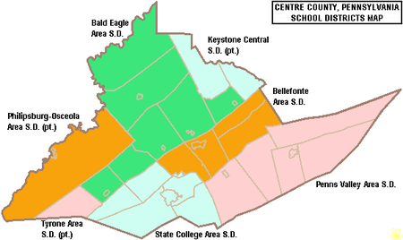
- Bald Eagle Area School District
- Bellefonte Area School District
- Keystone Central School District (also in Clinton County)
- Penns Valley Area School District
- Philipsburg-Osceola Area School District (also in Clearfield County)
- State College Area School District
- Tyrone Area School District (also in Blair County and Huntingdon County)
Public Charter Schools
- Young Scholars of Central PA Charter School
- Centre Learning Community Charter School
- Nittany Valley Charter School
- Wonderland Charter School
- There are 11 public cyber charter schools in Pennsylvania that are available for free statewide, to children K-12. See: Education in Pennsylvania.
Private Schools
As reported by the Pennsylvania Department of Education 2010.
- Bower Hollow Parochial School - Woodward
- Centre County Christian Academy - Bellefonte
- Elk Creek School - Rebersburg
- Faith Christian Academy - Philipsburg
- Grace Prep - State College
- Hill Side School - Rebersburg
- Hubler Ridge School - Bellefonte
- Kramer Gap School - Spring Mills
- Little Nittany Amish Parochial School - Howard
- Mountain View School - Rebersburg
- Nittany Christian School - State College
- Our Lady of Victory School - State College
- Peach Lane Amish School - Madisonburg
- Penns Valley Amish Paroch School - Woodward
- Rockville School - Rebersburg
- Spring Bank School - Rebersburg
- St John Evangelist School - Bellefonte
- State College Friends School - State College
- Sunny Meadow Parochial School - Howard
- Sunset View School - Howard
- Sunset View School - Rebersburg
- Windy Poplars School - Centre Hall
- Woodside Amish School - Spring Mills
Recreation
There are six Pennsylvania state parks in Centre County.
- Bald Eagle State Park is on Pennsylvania Route 150 between State College and Lock Haven.
- Black Moshannon State Park west of State College has a bog with three species of carnivorous plants and 17 orchid varieties.
- McCalls Dam State Park is a small park on a dirt road in the extreme eastern tip of the county.
- Penn-Roosevelt State Park is the site of a former segregated CCC camp for African American men.
- Poe Paddy State Park
- Poe Valley State Park
See also
- List of municipal authorities in Centre County, Pennsylvania
- National Register of Historic Places listings in Centre County, Pennsylvania
References
- ^ "Find a County". National Association of Counties. http://www.naco.org/Counties/Pages/FindACounty.aspx. Retrieved 2011-06-07.
- ^ "American FactFinder". United States Census Bureau. http://factfinder.census.gov. Retrieved 2008-01-31.
External links
- Official site
- Centre Daily Times Local Newspaper
- Interactive Web Mapping Application for Centre County
- Pennsylvania Historical and Museum Commission (PHMC) Historical Marker Search
Municipalities and communities of Centre County, Pennsylvania Boroughs Bellefonte | Centre Hall | Howard | Milesburg | Millheim | Philipsburg | Port Matilda | Snow Shoe | State College | Unionville
Townships CDPs Aaronsburg | Blanchard | Boalsburg | Clarence | Coburn | Eagleville | Houserville | Julian | Lemont | Madisonburg | Monument | North Philipsburg | Park Forest Village | Pine Glen | Pine Grove Mills | Pleasant Gap | Ramblewood | Rebersburg | Sandy Ridge | Spring Mills | Stormstown | Woodward | Zion
Unincorporated
communitiesColyer | Graysdale | Gum Stump | Ingleby | Peru | South Philipsburg | Struble | Tusseyville | University Park | Waddle
Categories:- Pennsylvania counties
- Centre County, Pennsylvania
- 1800 establishments in the United States
- Populated places established in 1800


Wikimedia Foundation. 2010.