- Columbia County, Pennsylvania
-
Columbia County, Pennsylvania 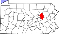
Location in the state of Pennsylvania
Pennsylvania's location in the U.S.Founded March 22, 1813 Seat Bloomsburg Largest city Bloomsburg Area
- Total
- Land
- Water
490 sq mi (1,269 km²)
486 sq mi (1,259 km²)
4 sq mi (10 km²), 0.87%Population
- (2010)
- Density
67,295
138/sq mi (53.4/km²)Website www.columbiapa.org Columbia County is a county located in the U.S. state of Pennsylvania. As of 2010, the population was 67,295.
Columbia County was created on March 22, 1813, from part of Northumberland County and named for Columbia, a poetic name for the United States that alludes to Christopher Columbus. Its county seat is Bloomsburg[1].
The county is part of the Bloomsburg–Berwick Micropolitan Statistical Area.
Contents
Politics and government
As of November 2008, there are 47,252 registered voters in Columbia County [1].
- Democratic: 20,961 (44.36%)
- Republican: 19,438 (41.14%)
- Other Parties: 6,853 (14.50%)
While the county registration tends to be evenly matched between Democrats and Republicans, the county trends Republican in statewide elections. While John McCain received 51.6% of its vote to 47.1% for Barack Obama, this was a far-closer margin than the 20 points that George W. Bush carried it by in 2004. Each of the three row-office statewide winners carried Columbia in 2008. In 2006, Democrat Bob Casey Jr. received 51% of its vote when he unseated incumbent Republican US Senator Rick Santorum and Ed Rendell received 50.6% of the vote against Lynn Swann.
For many years Columbia County was represented in the State House by a conservative Democrat in the 109th district until John Gordner changed parties to Republican in 2001. He was elected to the State Senate in 2003 and succeeded by Republican David R. Millard. Columbia is in the 27th Senate district and 11th Congressional district.
County commissioners
- David Kovach, Democrat
- Bill Soberick, Republican
- Chris Young, Republican
Other county officials
- Chief Clerk, Gail Kipp, Democrat
- Clerk of Courts and Prothonotary, Tami B. Kline, Republican
- Coroner, Lori Masteller, Republican
- District Attorney, Gary Norton, Republican
- Recorder of Deeds and Register of Wills, Beverly Michael, Democrat
- Sheriff, Tim Chamberlain, Democrat
- Treasurer, Shirley Turner, Republican
Pennsylvania State Senate
District Senator Party 27 John Gordner Republican Pennsylvania House of Representatives
District Senator Party 107 Kurt Masser Republican 109 David R. Millard Republican 117 Karen Boback Republican United States House of Representatives
District Representative Party 11 Lou Barletta Republican Party United States Senate
Senator Party Pat Toomey Republican Bob Casey Democrat Geography
According to the U.S. Census Bureau, the county has a total area of 490 square miles (1,269.1 km2), of which 486 square miles (1,258.7 km2) is land and 4 square miles (10.4 km2) (0.87%) is water.
Adjacent counties
- Sullivan County (north)
- Luzerne County (east)
- Schuylkill County (south)
- Northumberland County (southwest)
- Montour County (west)
- Lycoming County (northwest)
State Park
Part of Ricketts Glen State Park is in the northern portion of Columbia County.
Demographics
Historical populations Census Pop. %± 1820 17,621 — 1830 20,059 13.8% 1840 24,267 21.0% 1850 17,710 −27.0% 1860 25,065 41.5% 1870 28,766 14.8% 1880 32,409 12.7% 1890 36,832 13.6% 1900 39,896 8.3% 1910 48,467 21.5% 1920 48,349 −0.2% 1930 48,803 0.9% 1940 51,413 5.3% 1950 53,460 4.0% 1960 53,489 0.1% 1970 55,114 3.0% 1980 61,967 12.4% 1990 63,202 2.0% 2000 64,148 1.5% 2010 67,295 4.9% [2][3] As of the census[4] of 2000, there were 64,151 people, 24,915 households, and 16,568 families residing in the county. The population density was 132 people per square mile (51/km²). There were 27,733 housing units at an average density of 57 per square mile (22/km²). The racial makeup of the county was 97.59% White, 0.80% Black or African American, 0.15% Native American, 0.52% Asian, 0.03% Pacific Islander, 0.33% from other races, and 0.58% from two or more races. 0.95% of the population were Hispanic or Latino of any race. 33.2% were of German, 10.0% American, 9.4% Irish, 8.1% Italian, 6.7% Polish and 6.2% English ancestry according to Census 2000.
There were 24,915 households out of which 27.70% had children under the age of 18 living with them, 53.80% were married couples living together, 8.70% had a female householder with no husband present, and 33.50% were non-families. 26.60% of all households were made up of individuals and 11.80% had someone living alone who was 65 years of age or older. The average household size was 2.42 and the average family size was 2.90.
In the county, the population was spread out with 20.80% under the age of 18, 14.30% from 18 to 24, 25.90% from 25 to 44, 23.10% from 45 to 64, and 15.90% who were 65 years of age or older. The median age was 38 years. For every 100 females there were 90.80 males. For every 100 females age 18 and over, there were 87.80 males.
Municipalities
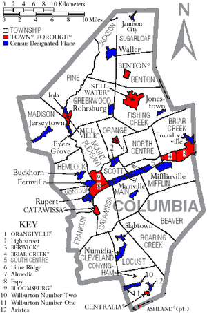 Map of Columbia County, Pennsylvania with Municipal Labels showing Towns and Boroughs (red), Townships (white), and Census-designated places (blue).
Under Pennsylvania law, there are four types of incorporated municipalities: cities, boroughs, townships, and, in at most two cases, towns. The following town, boroughs and townships are located in Columbia County:
Town
Boroughs
Townships
- Beaver Township
- Benton Township
- Briar Creek Township
- Catawissa Township
- Cleveland Township
- Conyngham Township
- Fishing Creek Township
- Franklin Township
- Greenwood Township
- Hemlock Township
- Jackson Township
- Locust Township
- Madison Township
- Main Township
- Mifflin Township
- Montour Township
- Mount Pleasant Township
- North Centre Township
- Orange Township
- Pine Township
- Roaring Creek Township
- Scott Township
- South Centre Township
- Sugarloaf Township
Census-designated places
Census-designated places are geographical areas designated by the U.S. Census Bureau for the purposes of compiling demographic data. They are not actual jurisdictions under Pennsylvania law. Other unincorporated communities, such as villages, may be listed here as well.
 Map of Columbia County, Pennsylvania School Districts
Education
Colleges and universities
Public School Districts
- Benton Area School District
- Berwick Area School District (also in Luzerne County)
- Bloomsburg Area School District
- Central Columbia School District
- Millville Area School District
- Mount Carmel Area School District (also in Northumberland County)
- North Schuylkill School District (also in Schuylkill County)
- Southern Columbia Area School District (also in Northumberland County)
Public Vo-Tech Schools
See also
- List of municipal authorities in Columbia County, Pennsylvania
- National Register of Historic Places listings in Columbia County, Pennsylvania
References
- ^ "Find a County". National Association of Counties. http://www.naco.org/Counties/Pages/FindACounty.aspx. Retrieved 2011-06-07.
- ^ http://factfinder2.census.gov
- ^ http://mapserver.lib.virginia.edu/
- ^ "American FactFinder". United States Census Bureau. http://factfinder.census.gov. Retrieved 2008-01-31.
Municipalities and communities of Columbia County, Pennsylvania Town 
Boroughs Ashland‡ | Benton | Berwick | Briar Creek | Catawissa | Centralia | Millville | Orangeville | Stillwater
Townships CDPs Almedia | Aristes | Buckhorn | Espy | Eyers Grove | Fernville | Foundryville | Iola | Jamison City | Jerseytown | Jonestown | Lightstreet | Lime Ridge | Locustdale | Mainville | Mifflinville | Numidia | Rohrsburg | Rupert | Slabtown | Waller | Wilburton Number One | Wilburton Number Two
Footnotes ‡This populated place also has portions in an adjacent county or counties
Categories:- Pennsylvania counties
- Columbia County, Pennsylvania
- Anthracite Coal Region of Pennsylvania
- 1813 establishments in the United States
- Populated places established in 1813
- Bloomsburg-Berwick micropolitan area


Wikimedia Foundation. 2010.