- Greene County, Pennsylvania
-
Greene County, Pennsylvania 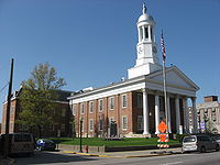 Greene County Courthouse in Waynesburg
Seal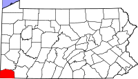
Location in the state of Pennsylvania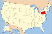
Pennsylvania's location in the U.S.Founded February 9, 1796 Seat Waynesburg Largest city Waynesburg Area
- Total
- Land
- Water
578 sq mi (1,497 km²)
576 sq mi (1,492 km²)
2 sq mi (5 km²), 0.36%Population
- (2010)
- Density
38,686
67/sq mi (25.9/km²)Website www.co.greene.pa.us Greene County is a county located in the U.S. state of Pennsylvania and is part of the Pittsburgh DMA. As of 2010, the population was 38,686.
Greene County was created on February 9, 1796, from part of Washington County and named for General Nathanael Greene.
Its county seat is Waynesburg[1].
Contents
Geography
According to the U.S. Census Bureau, the county has a total area of 578 square miles (1,497.0 km2), of which 576 square miles (1,491.8 km2) is land and 2 square miles (5.2 km2) (0.36%) is water.
Adjacent counties
- Washington County (north)
- Fayette County (east)
- Monongalia County, West Virginia (south)
- Wetzel County, West Virginia (southwest)
- Marshall County, West Virginia (west)

Washington County Marshall County, West Virginia 
Fayette County  Greene County, Pennsylvania

Wetzel County, West Virginia Monongalia County, West Virginia Demographics
Historical populations Census Pop. %± 1800 8,605 — 1810 12,544 45.8% 1820 15,554 24.0% 1830 18,028 15.9% 1840 19,147 6.2% 1850 22,136 15.6% 1860 24,343 10.0% 1870 25,887 6.3% 1880 28,273 9.2% 1890 28,935 2.3% 1900 28,281 −2.3% 1910 28,882 2.1% 1920 30,804 6.7% 1930 41,767 35.6% 1940 44,671 7.0% 1950 45,394 1.6% 1960 39,457 −13.1% 1970 39,108 −0.9% 1980 42,253 8.0% 1990 44,164 4.5% 2000 40,672 −7.9% 2010 38,686 −4.9% [2][3] As of the census[4] of 2000, there were 40,672 people, 15,060 households, and 10,587 families residing in the county. The population density was 71 people per square mile (27/km²). There were 16,678 housing units at an average density of 29 per square mile (11/km²). The racial makeup of the county was 99.9% White, 0.00% Black or African American, 0.05% Native American, 0.00% Asian, 0.00% Pacific Islander, 0.0% from other races, and 0.00% from two or more races. 0.00% of the population were Hispanic or Latino of any race. 18.2% were of German, 13.8% American, 12.9% English, 12.4% Irish, 8.2% Italian and 6.7% Polish ancestry according to Census 2000.
There were 15,060 households out of which 30.60% had children under the age of 18 living with them, 55.40% were married couples living together, 10.90% had a female householder with no husband present, and 29.70% were non-families. 25.70% of all households were made up of individuals and 12.70% had someone living alone who was 65 years of age or older. The average household size was 2.48 and the average family size was 2.97.
In the county, the population was spread out with 22.10% under the age of 18, 9.70% from 18 to 24, 29.00% from 25 to 44, 24.00% from 45 to 64, and 15.20% who were 65 years of age or older. The median age was 38 years. For every 100 females there were 106.20 males. For every 100 females age 18 and over, there were 106.50 males.
Municipalities
 Map of Greene County, Pennsylvania with Municipal Labels showing Boroughs (red), Townships (white), and Census-designated places (blue).
Under Pennsylvania law, there are four types of incorporated municipalities: cities, boroughs, townships, and, in at most two cases, towns. The following boroughs and townships are located in Greene County:
Boroughs
Townships
- Aleppo Township
- Center Township
- Cumberland Township
- Dunkard Township
- Franklin Township
- Freeport Township
- Gilmore Township
- Perry Township
- Richhill Township
- Springhill Township
- Washington Township
- Wayne Township
- Whiteley Township
Census-designated places
Census-designated places are geographical areas designated by the U.S. Census Bureau for the purposes of compiling demographic data. They are not actual jurisdictions under Pennsylvania law. Other unincorporated communities, such as villages, may be listed here as well.
 Map of Greene County, Pennsylvania School Districts
Government and politics
As of November 2010, there are 50,640 registered voters in Greene County [1].
- Democratic: 16,592 (65.53%)
- Republican: 6,840 (27.01%)
- Other Parties: 1,868 (7.45%)
County commissioners
- Pam Snyder, Chair, Democrat
- Charles Morris, Democrat
- Archie Trader, Republican
Other county officials
- President Judge, Hon. William R. Nalitz
- Associate Judge, Hon. Farley Toothman
- District Attorney, Marjorie J. Fox, Democrat
- Sheriff, Richard Ketchem, Democrat
- Coroner, Greg Rohanna, Democrat
- Clerk of Courts, Sherry Wise, Republican
- Prothonotary, Susan White, Democrat
- Recorder of Deeds and Register of Wills, Tom Headlee, Democrat
- Treasurer, Cory Grandel, Democrat
- Controller, David Balint, Democrat
State Representative
- H. William DeWeese, Democrat, 50th district
State Senator
- Tim Solobay, Democrat, 46th district
US Representative
- Mark Critz, Democrat, 12th district
Education
Public School Districts
- Carmichaels Area School District
- Central Greene School District
- Jefferson-Morgan School District
- Southeastern Greene School District
- West Greene School District
Highway Infrastructure
 Pennsylvania Route 18- the southernmost segments of one of the few Pennsylvania state routes to touch two state borders, this route begins at the West Virginia border in Freeport Township; after winding through the rolling hills of southwestern Greene County, it forms a consignment with Route 21 to reach the county seat in Waynesburg, before twisting back toward the northwest and into Washington County
 U.S. Route 19- although mostly parallel to and bypassed by the interstate system, this highway is a key north-south link in the county; entering from West Virginia and exiting into rural Washington County, this route connects a variety of small communities to Waynesburg, through which it is briefly cosigned with Route 21
 Pennsylvania Route 21- known as the Roy E. Furman Highway, this route is the east-west backbone of the county; the route begins at the border with the West Virginia panhandle, then winds through sparely populated western townships to Waynesburg; after forming the town’s main street, it includes a four-lane segment that features many of the region’s big box stores and commercial strips; the route alternates between two and four-lanes as it travels through hilly eastern villages before crossing the Monongahela River into Fayette County
 Interstate 79- as part of its journey between Morgantown, West Virginia and suburban Pittsburgh, this interstate highway breezes through Greene County, providing access to Waynesburg and several small communities
 Pennsylvania Route 88- part of a long, winding route that travels slowly through suburban Pittsburgh and the Monongahela Valley, this highway runs through small boroughs such as Carmicheals and Rices Landing during its stretch through the county, before exiting on a bridge over the Monongahela to reach its terminus in the small Fayette County town of Point Marion
 Pennsylvania Route 188- this short rural access route connects Franklin Township, which holds Waynesburg’s business district, with Morgan Township and Jefferson Township, before ending at its parent highway, Route 88
 Pennsylvania Route 218- this short rural access road connects Waynesburg with a West Virginia highway of the same number, after traveling through a sparely populated area
 Pennsylvania Route 221- this winding highway traverses northern townships in the county, entering from rural areas of Washington County and ending in Morgan Township at Route 188
 Pennsylvania Route 231- the final miles of this highway straddle the Washington-Greene County line, as the highway briefly enters Morris Township in its waning segments
See also
- List of municipal authorities in Greene County, Pennsylvania
- National Register of Historic Places listings in Greene County, Pennsylvania
Coordinates: 39°52′N 80°13′W / 39.86°N 80.22°W
References
- ^ "Find a County". National Association of Counties. http://www.naco.org/Counties/Pages/FindACounty.aspx. Retrieved 2011-06-07.
- ^ http://factfinder2.census.gov
- ^ http://mapserver.lib.virginia.edu/
- ^ "American FactFinder". United States Census Bureau. http://factfinder.census.gov. Retrieved 2008-01-31.
Municipalities and communities of Greene County, Pennsylvania Boroughs 
Townships Aleppo | Center | Cumberland | Dunkard | Franklin | Freeport | Gilmore | Gray | Greene | Jackson | Jefferson | Monongahela | Morgan | Morris | Perry | Richhill | Springhill | Washington | Wayne | Whiteley
CDPs Unincorporated
communitiesCategories:- Pennsylvania counties
- Greene County, Pennsylvania
- 1796 establishments


Wikimedia Foundation. 2010.