- Chester County, South Carolina
-
Chester County, South Carolina 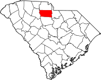
Location in the state of South Carolina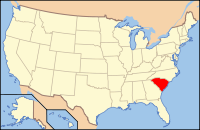
South Carolina's location in the U.S.Founded 1785 Seat Chester Area
- Total
- Land
- Water
586 sq mi (1,518 km²)
581 sq mi (1,505 km²)
6 sq mi (16 km²), 0.96%Population
- (2000)
- Density
34,068
60/sq mi (23/km²)Website www.chestercounty.org Chester County is a county located in the U.S. state of South Carolina. In 2000, its population was 34,068; in 2005 the U.S. Census Bureau estimated that its population had dropped to 33,228.[1] Its county seat is Chester.[2]
Contents
Geography and climate
According to the U.S. Census Bureau, the county has a total area of 586 square miles (1,517.7 km2), of which 581 square miles (1,504.8 km2) is land and 6 square miles (15.5 km2) (0.96%) is water.
Adjacent counties
- York County, South Carolina - north
- Lancaster County, South Carolina - east
- Fairfield County, South Carolina - south
- Union County, South Carolina - west
National protected area
- Sumter National Forest (part)
Demographics
 Chester County Courthouse
As of the census[3] of 2000, there were 34,068 people, 12,880 households, and 9,338 families residing in the county. The population density was 59 people per square mile (23/km²). There were 14,374 housing units at an average density of 25 per square mile (10/km²). The racial makeup of the county was 59.93% White, 38.65% Black or African American, 0.33% Native American, 0.28% Asian, 0.01% Pacific Islander, 0.25% from other races, and 0.55% from two or more races. 0.75% of the population were Hispanic or Latino of any race.
There were 12,880 households out of which 32.90% had children under the age of 18 living with them, 48.80% were married couples living together, 18.60% had a female householder with no husband present, and 27.50% were non-families. 24.20% of all households were made up of individuals and 9.90% had someone living alone who was 65 years of age or older. The average household size was 2.62 and the average family size was 3.11.
In the county, the population was spread out with 26.90% under the age of 18, 8.40% from 18 to 24, 28.20% from 25 to 44, 23.80% from 45 to 64, and 12.70% who were 65 years of age or older. The median age was 36 years. For every 100 females there were 92.50 males. For every 100 females age 18 and over, there were 87.60 males.
The median income for a household in the county was $32,425, and the median income for a family was $38,087. Males had a median income of $30,329 versus $21,570 for females. The per capita income for the county was $14,709. About 11.90% of families and 15.30% of the population were below the poverty line, including 21.20% of those under age 18 and 14.90% of those age 65 or over.
Communities
City
Towns
Other Populated Places
- Blackstock
- Edgemoor
- Eureka Mill
- Gayle Mill
- Lando
- Leeds
- Wilksburg
Notable residents
- John Adair, (1757–1840), born in Chester County (although at the time it was believed to be part of Anson County, North Carolina),[4] would become a member of the United States House of Representatives and the United States Senate, and governor of Kentucky[5]
- Thomas and Meeks Griffin wrongly executed in South Carolina's electric chair in 1915. They were framed in Chester County in 1913 and pardoned in 2009.
See also
- National Register of Historic Places listings in Chester County, South Carolina
- Tryon County, North Carolina
External links
References
- ^ http://www.census.gov/popest/counties/tables/CO-EST2005-01-45.xls
- ^ "Find a County". National Association of Counties. http://www.naco.org/Counties/Pages/FindACounty.aspx. Retrieved 2011-06-07.
- ^ "American FactFinder". United States Census Bureau. http://factfinder.census.gov. Retrieved 2008-01-31.
- ^ http://www.carolana.com/NC/Counties/tryon_county_nc.html Tryon County, North Carolina History, by Alfred Nixon, 1910
- ^ Who Was Who in America, Historical Volume, 1607-1896. Chicago: Marquis Who's Who. 1963.
Municipalities and communities of Chester County, South Carolina City 
Towns Fort Lawn | Great Falls | Lowrys | Richburg
CDPs Unincorporated
communitiesBlackstock‡ | Edgemoor | Lando | Leeds | Wilksburg
Footnotes ‡This populated place also has portions in an adjacent county or counties
 State of South Carolina
Regions Larger cities Smaller cities Towns CDPs Counties - Abbeville
- Aiken
- Allendale
- Anderson
- Bamberg
- Barnwell
- Beaufort
- Berkeley
- Calhoun
- Charleston
- Cherokee
- Chester
- Chesterfield
- Clarendon
- Colleton
- Darlington
- Dillon
- Dorchester
- Edgefield
- Fairfield
- Florence
- Georgetown
- Greenville
- Greenwood
- Hampton
- Horry
- Jasper
- Kershaw
- Lancaster
- Laurens
- Lee
- Lexington
- Marion
- Marlboro
- McCormick
- Newberry
- Oconee
- Orangeburg
- Pickens
- Richland
- Saluda
- Spartanburg
- Sumter
- Union
- Williamsburg
- York
Topics - History
- Famous people
- Governors
- Legislature
- State House
- Congressional districts
- Census areas
- State parks
- Rivers
- Wildlife refuges
- Historic places
- Amusement parks
- Colleges and universities
- Sports venues
- Shopping malls
- Television stations
- Radio stations
- Highways
- Airports
- Visitor attractions
Charlotte Metropolitan Area Counties 
Major city Cities and towns
20k-99kConcord • Gastonia • Huntersville • Kannapolis • Matthews • Monroe • Hickory • Mooresville • Rock Hill • Salisbury • Shelby • StatesvilleCities and towns
5k-20kAlbemarle • Belmont • Bessemer City • Chester • Cherryville • Conover • Cornelius • Davidson • Fort Mill • Indian Trail • Kings Mountain • Lancaster • Lincolnton • Mint Hill • Mount Holly • South Gastonia • Unionville • Wadesboro • Weddington • YorkFootnotes Bold = principal metro cities • Italic = places and counties part of CSACategories:- South Carolina counties
- Geography of South Carolina
- Chester County, South Carolina
- 1785 establishments


Wikimedia Foundation. 2010.