- Meade County, South Dakota
-
Meade County, South Dakota 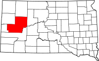
Location in the state of South Dakota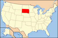
South Dakota's location in the U.S.Founded 1889 Named for General George Meade Seat Sturgis Area
- Total
- Land
- Water
3,482 sq mi (9,020 km²)
3,471 sq mi (8,989 km²)
12 sq mi (31 km²), 0.34%Population
- (2010)
- Density
25,434
7/sq mi (3/km²)Time zone Mountain: UTC-7/-6 Website www.meadecounty.org Meade County is a county located in the U.S. state of South Dakota. It was created in 1889 and was named for Fort Meade, which was garrisoned as a United States military post in the area in 1878 and was named for General George Meade. As of the 2010 census, the population was 25,434. Its county seat is Sturgis.[1]
Meade County is part of the Rapid City, South Dakota, Metropolitan Statistical Area.
Contents
Geography
According to the U.S. Census Bureau, the county has a total area of 3,482 square miles (9,020 km2), the largest county in South Dakota, of which 3,471 square miles (8,990 km2) is land and 12 square miles (31 km2) (0.34%) is water.
Townships
The county is divided into seven townships: Dakota, Eagle, Howard, Lakeside, Smithville, and Upper Red Owl; and three areas of unorganized territory: Belle Fourche-Cheyenne Valleys, North Meade, and Southwest Meade.
Major highways
 Interstate 90
 U.S. Highway 14
- U.S. Highway 14A
 U.S. Highway 212
 South Dakota Highway 34
 South Dakota Highway 73
 South Dakota Highway 79
Adjacent counties
- Perkins County, South Dakota - north
- Ziebach County, South Dakota - east
- Pennington County, South Dakota - south
- Lawrence County, South Dakota - southwest
- Butte County, South Dakota - northwest
National protected area
- Bear Butte National Wildlife Refuge
- Black Hills National Forest (part)
History
Meade County was established in 1889 and named for Fort Meade.
Demographics
Historical populations Census Pop. %± 1890 4,640 — 1900 4,907 5.8% 1910 12,640 157.6% 1920 9,367 −25.9% 1930 11,482 22.6% 1940 9,735 −15.2% 1950 11,516 18.3% 1960 12,044 4.6% 1970 16,618 38.0% 1980 20,717 24.7% 1990 21,878 5.6% 2000 24,253 10.9% 2010 25,434 4.9% U.S. Decennial Census As of the census[2] of 2000, there were 24,253 people, 8,805 households, and 6,700 families residing in the county. The population density was 7 people per square mile (3/km²). There were 10,149 housing units at an average density of 3 per square mile (1/km²). The racial makeup of the county was 92.65% White, 1.48% Black or African American, 2.04% Native American, 0.63% Asian, 0.07% Pacific Islander, 0.61% from other races, and 2.52% from two or more races. 2.10% of the population were Hispanic or Latino of any race.
There were 8,805 households out of which 39.90% had children under the age of 18 living with them, 64.40% were married couples living together, 8.30% had a female householder with no husband present, and 23.90% were non-families. 19.90% of all households were made up of individuals and 7.50% had someone living alone who was 65 years of age or older. The average household size was 2.66 and the average family size was 3.05.
In the county, the population was spread out with 28.40% under the age of 18, 10.60% from 18 to 24, 29.60% from 25 to 44, 21.00% from 45 to 64, and 10.40% who were 65 years of age or older. The median age was 33 years. For every 100 females there were 102.20 males. For every 100 females age 18 and over, there were 101.60 males.
The median income for a household in the county was $36,992, and the median income for a family was $40,537. Males had a median income of $26,572 versus $20,517 for females. The per capita income for the county was $17,680. About 7.90% of families and 9.40% of the population were below the poverty line, including 11.80% of those under age 18 and 6.10% of those age 65 or over.
Cities and towns
- Ellsworth AFB
- Mud Butte
- Piedmont
- Tilford
- White Owl
2010 United States Census population[3]
See also
References
- ^ "Find a County". National Association of Counties. http://www.naco.org/Counties/Pages/FindACounty.aspx. Retrieved 2011-06-07.
- ^ "American FactFinder". United States Census Bureau. http://factfinder.census.gov. Retrieved 2008-01-31.
- ^ "Incorporated Places and Minor Civil Divisions: South Dakota". Population Census. 2010 United States Census. 2011-07-18. http://factfinder2.census.gov/faces/tableservices/jsf/pages/productview.xhtml?pid=DEC_10_PL_GCTPL1.ST13&prodType=table. Retrieved 2011-08-03.
External links

Butte County Perkins County 
Ziebach County  Meade County, South Dakota

Lawrence County Pennington County Municipalities and communities of Meade County, South Dakota Cities 
CDPs Unincorporated
communitiesElm Springs | Enning | Howes | Mud Butte | White Owl
Indian reservations Footnotes ‡This populated place also has portions in an adjacent county or counties
Categories:- South Dakota counties
- Meade County, South Dakota
- 1889 establishments
- Rapid City metropolitan area
- Black Hills


Wikimedia Foundation. 2010.