- Michigan census statistical areas
-
The United States Census Bureau has defined 5 Combined Statistical Areas (CSAs),[1] 15 Metropolitan Statistical Areas (MSAs),[2] and 18 Micropolitan Statistical Areas (μSAs)[3] in the State of Michigan.[4] The following table describes these areas with the following information:
- The name of the Combined Statistical Area (CSA), if any.[1][5]
- The population of the CSA as of the 2010 United States Census.
- The name of the Core Based Statistical Area (CBSA).[6][5]
- The population of the CBSA as of the 2010 United States Census.
- The name of the county.[5]
- The population of the county as of the 2010 United States Census.
 Map of the 83 counties of the State of Michigan.
Census Statistical Areas Combined Statistical Areas Metropolitan Statistical Areas Micropolitan Statistical Areas 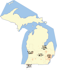
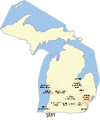
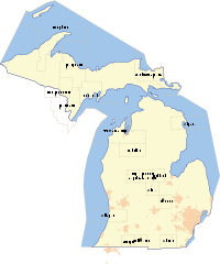
United States Census Bureau Statistical Areas in the State of Michigan Combined Statistical Area 2010 Pop Core Based Statistical Area 2010 Pop County 2010 Pop Detroit-Ann Arbor-Flint, MI CSA 5,218,852 Detroit-Warren-Livonia, MI MSA 4,296,250 Wayne County, Michigan 1,820,584 Oakland County, Michigan 1,202,362 Macomb County, Michigan 840,978 Livingston County, Michigan 180,967 St. Clair County, Michigan 163,040 Lapeer County, Michigan 88,319 Flint, MI MSA 425,790 Genesee County, Michigan 425,790 Ann Arbor, MI MSA 344,791 Washtenaw County, Michigan 344,791 Monroe, MI MSA 152,021 Monroe County, Michigan 152,021 Grand Rapids-Muskegon-Holland, MI CSA 1,321,557 Grand Rapids-Wyoming, MI MSA 774,160 Kent County, Michigan 602,622 Ionia County, Michigan 63,905 Barry County, Michigan 59,173 Newaygo County, Michigan 48,460 Holland-Grand Haven, MI MSA 263,801 Ottawa County, Michigan 263,801 Muskegon-Norton Shores, MI MSA 172,188 Muskegon County, Michigan 172,188 Allegan, MI μSA 111,408 Allegan County, Michigan 111,408 Lansing-East Lansing-Owosso, MI CSA 534,684 Lansing-East Lansing, MI MSA 464,036 Ingham County, Michigan 280,895 Eaton County, Michigan 107,759 Clinton County, Michigan 75,382 Owosso, MI μSA 70,648 Shiawassee County, Michigan 70,648 primary census statistical area 326,589 Kalamazoo-Portage, MI MSA 326,589 Kalamazoo County, Michigan 250,331 Van Buren County, Michigan 76,258 Saginaw-Bay City-Saginaw Township North, MI CSA 307,940 Saginaw-Saginaw Township North, MI MSA 200,169 Saginaw County, Michigan 200,169 Bay City, MI MSA 107,771 Bay County, Michigan 107,771 primary census statistical area 160,248 Jackson, MI MSA 160,248 Jackson County, Michigan 160,248 primary census statistical area 156,813 Niles-Benton Harbor, MI MSA 156,813 Berrien County, Michigan 156,813 primary census statistical area 143,372 Traverse City, MI μSA 143,372 Grand Traverse County, Michigan 86,986 Leelanau County, Michigan 21,708 Benzie County, Michigan 17,525 Kalkaska County, Michigan 17,153 primary census statistical area 136,146 Battle Creek, MI MSA 136,146 Calhoun County, Michigan 136,146 primary census statistical area 99,892 Adrian, MI μSA 99,892 Lenawee County, Michigan 99,892 primary census statistical area 83,629 Midland, MI μSA 83,629 Midland County, Michigan 83,629 primary census statistical area 70,311 Mount Pleasant, MI μSA 70,311 Isabella County, Michigan 70,311 primary census statistical area 67,077 Marquette, MI μSA 67,077 Marquette County, Michigan 67,077 primary census statistical area 61,295 Sturgis, MI μSA 61,295 St. Joseph County, Michigan 61,295 South Bend-Elkhart-Mishawaka, IN-MI CSA[5] 563,834 South Bend-Mishawaka, IN-MI MSA 319,224 St. Joseph County, Indiana 266,931 Cass County, Michigan 52,293 Elkhart-Goshen, IN MSA 197,559 Elkhart County, Indiana 197,559 Plymouth, IN μSA 47,051 Marshall County, Indiana 47,051 primary census statistical area 47,584 Cadillac, MI μSA 47,584 Wexford County, Michigan 32,735 Missaukee County, Michigan 14,849 primary census statistical area 45,248 Coldwater, MI μSA 45,248 Branch County, Michigan 45,248 primary census statistical area 42,798 Big Rapids, MI μSA 42,798 Mecosta County, Michigan 42,798 primary census statistical area 42,476 Alma, MI μSA 42,476 Gratiot County, Michigan 42,476 primary census statistical area 38,784 Houghton, MI μSA 38,784 Houghton County, Michigan 36,628 Keweenaw County, Michigan 2,156 primary census statistical area 38,520 Sault Ste. Marie, MI μSA 38,520 Chippewa County, Michigan 38,520 primary census statistical area 37,069 Escanaba, MI μSA 37,069 Delta County, Michigan 37,069 primary census statistical area 29,598 Alpena, MI μSA 29,598 Alpena County, Michigan 29,598 primary census statistical area[5] 30,591 Iron Mountain, MI-WI μSA 30,591 Dickinson County, Michigan 26,168 Florence County, Wisconsin 4,423 primary census statistical area[5] 65,778 Marinette, WI-MI μSA 65,778 Marinette County, Wisconsin 41,749 Menominee County, Michigan 24,029 none Montcalm County, Michigan 63,342 Tuscola County, Michigan 55,729 Hillsdale County, Michigan 46,688 Sanilac County, Michigan 43,114 Huron County, Michigan 33,118 Emmet County, Michigan 32,694 Clare County, Michigan 30,926 Mason County, Michigan 28,705 Oceana County, Michigan 26,570 Cheboygan County, Michigan 26,152 Charlevoix County, Michigan 25,949 Iosco County, Michigan 25,887 Gladwin County, Michigan 25,692 Manistee County, Michigan 24,733 Roscommon County, Michigan 24,449 Otsego County, Michigan 24,164 Antrim County, Michigan 23,580 Osceola County, Michigan 23,528 Ogemaw County, Michigan 21,699 Gogebic County, Michigan 16,427 Arenac County, Michigan 15,899 Crawford County, Michigan 14,074 Presque Isle County, Michigan 13,376 Iron County, Michigan 11,817 Lake County, Michigan 11,539 Mackinac County, Michigan 11,113 Alcona County, Michigan 10,942 Montmorency County, Michigan 9,765 Alger County, Michigan 9,601 Baraga County, Michigan 8,860 Oscoda County, Michigan 8,640 Schoolcraft County, Michigan 8,485 Ontonagon County, Michigan 6,780 Luce County, Michigan 6,631 See also
 United States census statistical areas by state, district, or territoryMIASMPGUVI
- State of Michigan
- Demographics of Michigan
- Geography of Michigan
- List of Michigan-related topics
- United States
References
- ^ a b The United States Census Bureau defines a Combined Statistical Area (CSA) as an aggregate of adjacent Core Based Statistical Areas that are linked by commuting ties.
- ^ The United States Census Bureau defines a Metropolitan Statistical Area (MSA) as a Core Based Statistical Area having at least one urbanized area of 50,000 or more population, plus adjacent territory that has a high degree of social and economic integration with the core as measured by commuting ties.
- ^ The United States Census Bureau defines a Micropolitan Statistical Area (μSA) as a Core Based Statistical Area having at least one urban cluster of at least 10,000 but less than 50,000 population, plus adjacent territory that has a high degree of social and economic integration with the core as measured by commuting ties.
- ^ "OMB Bulletin No. 07-01: Update of Statistical Area Definitions and Guidance on Their Uses" (PDF). United States Office of Management and Budget. 2006-12-18. http://www.whitehouse.gov/omb/bulletins/fy2007/b07-01.pdf. Retrieved 2007-04-10.
- ^ a b c d e f An area that extends into more than one state is displayed in teal. An out-of-state area is displayed in green.
- ^ The United States Census Bureau defines a Core Based Statistical Area (CBSA) as one or more adjacent counties or county equivalents that have at least one urban cluster of at least 10,000 population, plus adjacent territory that has a high degree of social and economic integration with the core as measured by commuting ties. The Census Bureau has defined two types of CBSAs: (1) a Metropolitan Statistical Area (MSA), which has an urban core population of 50,000 or more, or (2) a Micropolitan Statistical Area (μSA), which has an urban core population of 10,000 or more but less than 50,000.
External links
Categories:- Metropolitan areas of Michigan
- Micropolitan areas of Michigan
- Census statistical areas
- Michigan-related lists


Wikimedia Foundation. 2010.