- Charleston Lake Provincial Park
-
Charleston Lake Provincial Park IUCN Category II (National Park)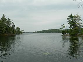
Charleston Lake from Slim Bay bridgeLocation Outlet, Canada Nearest city Brockville Coordinates 44°30′10″N 76°02′26″W / 44.50278°N 76.04056°WCoordinates: 44°30′10″N 76°02′26″W / 44.50278°N 76.04056°W Area 23.53 km² Established 1972 Governing body Ontario Parks Charleston Lake Provincial Park is located on Charleston Lake near Athens, Ontario, Canada in the township of Leeds and the Thousand Islands.
The park occupies 23.53 km² in the Frontenac Axis region, a southern extension of the Canadian Shield. The park's forests and animal life, therefore, include species normally found further north, yet the southern climate allows species more typical for the southern latitude to co-exist with the northern species. The park includes hiking trails, swimming areas and campgrounds.
The lake includes a number of islands and has an irregular shoreline which makes it an interesting location for canoeing and kayaking. The trail to Blue Mountain is only accessible by water.
Blue Mountain is also accessible off Hwy #2 on Blue Mountain Rd. It is necessary to cross private land and hard-to-follow trails to reach the summit of the breathtaking 360° view. The trek requires approx. 2 to 2.5 hours on foot or 1.5 hrs. on bike, although cyclists must carry their bikes in many places where hard granite jets out of the earth below which forms the mountain. A compass may be useful for inexperienced hikers.
This area was the site of a re-introduction program for the peregrine falcon. The park also provides habitat for the rare and harmless black rat snake, which is also the largest snake found in eastern Ontario.
Notable personalities
Gallery
-

floating bridge, Slim Bay
External links
Protected areas in Ontario National parks 
Provincial parks Conservation areas Boyd · Claireville · Cold Creek · Guelph Lake · Heber Down · Kortright Centre · Lake Laurentian · Mer Bleue · Mount Nemo · Rattlesnake Point · Spencer Gorge / Webster's Falls · more...UNESCO Biosphere Reserves Georgian Bay Littoral · Long Point · Niagara Escarpment (including Cheltenham Badlands) · Thousand Islands - Frontenac Arch · Wasaga BeachNational Historic Sites of Canada Central Experimental Farm · Dundurn Castle · Laurier House · Massey Hall · Montgomery's Tavern · Osgoode Hall · Parliament · Rideau Canal · Rideau Hall · more...Other areas Categories:- IUCN Category II
- Provincial parks in Ontario
- Eastern Ontario geography stubs
- Canadian protected area stubs
-


Wikimedia Foundation. 2010.