- Government Center (MBTA station)
-
GOVERNMENT CENTERGOVERNMENT CENTER
Government Center headhouseStation statistics Address Near Boston City Hall at intersection of Tremont, Court and Cambridge Streets, Downtown Boston Coordinates 42°21′34.46″N 71°3′33.59″W / 42.3595722°N 71.0593306°WCoordinates: 42°21′34.46″N 71°3′33.59″W / 42.3595722°N 71.0593306°W Lines Green Line (all branches)Platforms 1 island platform (Blue Line)
1 triangular island platform (Green Line)Tracks Blue Line: 2
Green Line: 2 plus non-revenue loop trackOther information Opened September 3, 1898 (Green Line)
March 18, 1916 (Blue Line)Owned by MBTA Formerly Scollay (1898–1969) Traffic Passengers (1997) 4.182 million  0%
0%Services Preceding station MBTA Following station toward Boston CollegeGreen Line "B" BranchTerminus toward RiversideGreen Line "D" Branchtoward Cleveland CircleGreen Line "C" Branchtoward North Stationtoward Heath StreetGreen Line "E" Branchtoward LechmereTerminusBlue Line Weekdays 5:15am-6:30pmtoward WonderlandTerminus Blue Line Evenings, Weekends, and HolidaysGovernment Center is an MBTA subway station and a transfer point between the Green Line and the Blue Line. It is located at the intersection of Tremont, Court and Cambridge Streets in the Government Center area of Boston.
Contents
History
 The Scollay Under sign reflected in a Blue Line train
Before the current Boston City Hall was built at its current location, completely replacing old Scollay Square, the station was known as Scollay on the Green Line and Scollay Under on the Blue Line. Years later, when the false walls on both ends of the Blue Line platform were removed to accommodate the change from four- to six-car trains, several surviving mosaic tile "Scollay Under" signs were uncovered, which can be seen on both ends of the platform.
Government Center station was featured in the video game Tony Hawk's Underground 2 in the Boston level.
Congestion and Red-Blue Connector
As of 2011, the Green Line is the most convenient way to transfer between the Blue Line and the Red Line, thus causing the short Green Line segment between Government Center station and nearby Park Street station to be especially congested during peak travel times. This bottleneck, combined with tight platform clearances on the Green Line outbound side, has been the cause of significant delays and crowding on the Green Line. In the past, an underground pedestrian passage had been proposed, paralleling the Green Line tracks and connecting the two stations, but this idea was dropped in favor of a direct transfer connection between the Blue and Red Lines.
It also is possible to transfer between the Red and Blue Lines by traveling one stop on the Orange Line between State and Downtown Crossing stations, but this path involves navigating a longer and more convoluted path through stairs and passages of those stations. The Red and Blue Lines are the only pair of rapid transit lines in the MBTA system that lack a direct transfer connection.
As part of a lawsuit settlement relating to air quality mitigation for the Big Dig highway tunnel project, the Commonwealth of Massachusetts agreed to build a direct transfer connection between the Blue and Red Lines. This would be done by extending the Blue Line beyond Bowdoin station, continuing to run a further 1500 feet (450 m) beneath Cambridge Street to Charles/MGH station on the Red Line. Unlike the historic non-revenue Red/Blue Line connection, there would be no direct rail connection between the lines at Charles/MGH station (the rail gauges are identical, but the Red and Blue Line railcars are otherwise dimensionally incompatible). However, passengers would be able to transfer between the Red and Blue Lines without needing to crowd onto the Green Line, and many passengers from the North Shore of Boston would be able to reach the Massachusetts General Hospital area directly without further transfers.
After failing to take any action for over a decade, and under threat of further lawsuits, the state finally agreed to start detailed engineering design for such an extension, which is ongoing as of 2011. Construction is expected to take 6 years, but a start date and funding scheme have not yet been announced.[1][2][3]
Accessibility
See also: MBTA accessibilityAs of 2011, Government Center is not wheelchair accessible, with the exception of accessible inbound and outbound transfers on the Blue Line.
Renovation
A renovation that will make the station more accessible and relieve some overcrowding is planned, including rebuilding of the headhouse and installation of elevators. As part of the project, a second headhouse has been proposed on Cambridge Street in the direction of Bowdoin station (the Blue Line terminus), a stop which the MBTA may eventually close.[4] However, Bowdoin is scheduled to remain open during the Government Center station reconstruction.[5]
Currently there are plans to shut Government Center station down for two years, which would save $16 million and shorten the project by 15 months, compared to keeping the station open during construction. Construction is planned to begin in November 2012. [5][6]
Attractions
- Boston City Hall, seat of the city's government
- John F. Kennedy Federal Building
- Faneuil Hall
- Quincy Market
- Freedom Trail
- Shops and restaurants
Gallery
-

A "D" Branch Green line train bound for Riverside station
-

A Blue line train arrives at Government Center
-

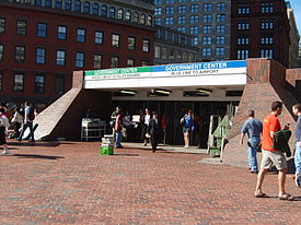
The entrance down to Government Center Station
-

Blue Line platform
References
- ^ "Red Line Blue Line Connector". Mass.gov. Commonwealth of Massachusetts. http://www.eot.state.ma.us/redblue/. Retrieved 2011-07-27.
- ^ "Red Line Blue Line Connector Factsheet". Mass.gov. Commonwealth of Massachusetts. http://www.eot.state.ma.us/redblue/downloads/FactSheet2_050310.pdf. Retrieved 2011-07-27.
- ^ "State agrees to design link between Red and Blue lines". The Boston Globe. November 30, 2006. http://www.boston.com/news/local/articles/2006/11/30/state_agrees_to_design_link_between_red_and_blue_lines/. Retrieved 2007-10-14.
- ^ Trop, Jaclyn (24 October 2006). "Bowdoin Street station to close in three years". Beacon Hill Times. http://www.beaconhilltimes.com/archive/news_db/20061024/20061024.html. Retrieved 12 April 2011.
- ^ a b Moskowitz, Eric (10 April 2011). "On Government Center project, T leaning toward 2-year closure". Boston Globe. http://www.boston.com/news/local/massachusetts/articles/2011/04/10/on_government_center_project_t_leaning_toward_2_year_closure/. Retrieved 12 April 2011.
- ^ "Government Center Modernization". T Projects. Massachusetts Bay Transportation Authority. http://www.mbta.com/about_the_mbta/t_projects/projects_accessibility/?id=1004. Retrieved 12 April 2011.
Further reading
- Belcher, Jonathan, "Remnants of Abandoned Stations, Tunnels, and Station Entrances found on the MBTA" (archived 2007)
- Bierman, Noah, "Transit archeology: Tour of abandoned subway network offers a glimpse of how the T was built", Boston Globe, Saturday, December 26, 2009.
- Cheape, Charles W. (1980). Moving the masses : urban public transport in New York, Boston and Philadelphia, 1880-1912. Cambridge, Mass.: Harvard University Press. ISBN 0674588274. http://books.google.com/books?id=NkDeRf2FKTkC&printsec=frontcover#v=onepage&q&f=false.
- Cheney, Frank; Sammarco, Anthony Mitchell (2000). When Boston rode the El. Charleston, SC: Arcadia. ISBN 978-0738504629. http://books.google.com/books?id=FXsLiV1aNRUC&printsec=frontcover#v=onepage&q&f=false.
- Cudahy, Brian J. (1972). Change at Park Street Under; the story of Boston's subways. Brattleboro, Vt.: S. Greene Press. ISBN 978-0828901734.
- McKendry, Joe (2006). Beneath the streets of Boston: Building America's first subway. Boston: David R. Godine. ISBN 978-1567922844.
External links
- MBTA Green & Blue Lines -- Government Center Station
- Court Street entrance from Google Maps Street View
Currently operating light rail and streetcar systems in the United States ArkansasArizonaCaliforniaMUNI: Cable Car, F Market & Wharves, and Metro lines · Metro Rail: Blue Line, Green Line and Gold Line · Sacramento RT · San Diego Trolley · Sprinter · Santa Clara VTA · Waterfront Red CarColoradoFloridaGeorgiaRiver Street StreetcarLouisianaMassachusettsMarylandMinnesotaMissouri / IllinoisNew JerseyNew YorkNorth CarolinaOhioOregonPennsylvaniaPittsburgh Light Rail · SEPTA Routes 15, 101, 102, and Subway–Surface LinesTennesseeTexasUtahVirginiaWashingtonLink Light Rail · Seattle Streetcar NetworkWisconsinCategories:- Blue Line (MBTA) stations
- Railway stations located underground in Boston, Massachusetts
- Railway stations opened in 1898
- Green Line (MBTA) stations
- Government Center, Boston


Wikimedia Foundation. 2010.