Namibe Airport

Namibe Airport
Namibe Airport
Aeroporto de Namibe
IATA: MSZICAO: FNMO
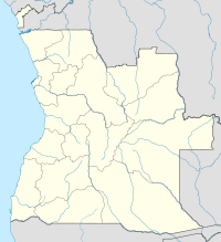
MSZ is located in Angola
{{{alt}}}
MSZ
Location of Airport in Angola
Summary
Airport type Public / Military
Serves Namibe, Angola
Elevation AMSL 210 ft / 64 m
Coordinates 15°15′40″S 012°08′48″E / 15.26111°S 12.14667°E / -15.26111; 12.14667
Runways
Direction Length Surface
m ft
08/26 2,500 8,202 Asphalt
Source: DAFIF[1][2]

Namibe Airport (Portuguese: Aeroporto de Namibe) (IATA: MSZICAO: FNMO) is an airport serving Namibe,[1] the capital city of the Namibe province in Angola.

Contents

Facilities

The airport resides at an elevation of 210 feet (64 m) above mean sea level. It has 1 runway designated 08/26 with an asphalt surface measuring 2,500 by 45 metres (8,202 × 148 ft).[1]

Airlines and scheduled destination

Airlines Destinations
TAAG Angola Airlines Luanda, Menongue

References

  1. ^ a b c Airport information for FNMO from DAFIF (effective October 2006)
  2. ^ Airport information for MSZ at Great Circle Mapper. Source: DAFIF (effective Oct. 2006).

External links


Wikimedia Foundation. 2010.

Игры ⚽ Нужно решить контрольную?

Look at other dictionaries:

  • Namibe — (pre 1985: Moçâmedes) is the capital city of Namibe Province in Angola. It is a coastal desert city located in southwestern Angola and was founded in 1840 by the Portuguese rulers of the territory. The city s current population is 132,900 (2004… …   Wikipedia

  • Namibe — ▪ Angola formerly  (until 1982) Moçâmedes,  also spelled  Mossamedes         city and port, southwestern Angola. Founded by Brazilians in the mid 19th century and located on an arid coastal strip from which rises the steep Huíla escarpment,… …   Universalium

  • Quatro de Fevereiro Airport — Infobox Airport name = Quatro de Fevereiro Airport nativename = nativename a = nativename r = image width = caption = IATA = LAD ICAO = FNLU type = Military/Public owner = operator = Military of Angola city served = location = Luanda elevation f …   Wikipedia

  • Menongue Airport — Aeroporto de Menongue IATA: SPP – ICAO: FNME …   Wikipedia

  • TAAG Angola Airlines destinations — TAAG Angola Airlines operates the following services (as at April 2007): Africa *Angola **Cabinda (Cabinda Airport) CAB **Catumbela (Catumbela Airport) CBT **Dundo (Dundo Airport) DUE **Huambo (Nova Lisboa Airport) NOV **Luena (Luena Airport) LUO …   Wikipedia

  • Liste Des Codes OACI Des Aéroports/F — A B C D E F G H I J K L M N O P Q R S T U V W X Y Z Format des données : Code OACI (code AITA) – Nom de l aérodrome – Ville desservie (département) – Altitude aérodrome – Nombre de …   Wikipédia en Français

  • Liste des codes OACI des aeroports/F — Liste des codes OACI des aéroports/F A B C D E F G H I J K L M N O P Q R S T U V W X Y Z Format des données : Code OACI (code AITA) – Nom de l aérodrome – Ville desservie (département) – Altitude aérodrome – Nombre de …   Wikipédia en Français

  • Liste des codes OACI des aéroports/F — A B C D E F G H I J K L M N O P Q R S T U V W X Y Z Format des données : Code OACI (code AITA) – Nom de l aérodrome – Ville desservie (département) – Altitude aérodrome – Nombre de …   Wikipédia en Français

  • Liste des codes oaci des aéroports/f — A B C D E F G H I J K L M N O P Q R S T U V W X Y Z Format des données : Code OACI (code AITA) – Nom de l aérodrome – Ville desservie (département) – Altitude aérodrome – Nombre de …   Wikipédia en Français

  • Angola — Angolan, adj., n. /ang goh leuh/, n. a republic in SW Africa: formerly an overseas province of Portugal; gained independence Nov. 11, 1975. 10,623,994; 481,226 sq. mi. (1,246,375 sq. km). Cap.: Luanda. Formerly, Portuguese West Africa. * * *… …   Universalium

Share the article and excerpts

Direct link
Do a right-click on the link above
and select “Copy Link”